- Hashim, M., and Myzairah Hamzah (eds) (2022). Water, Climate and Earth Observations. ISBN 978-983-52-1835-4, Penerbit UTM Press, Universiti Teknologi Malaysia, Johor Bahru. Pp178.
- Hashim M., Ahmad S., Wang Y.C. (2014), Preface, IOP Conference Series: Earth and Environmental Science, 18 (1), art. no. 011001, DOI: 10.1088/1755-1315/18/1/011001, https://www.scopus.com/inward/record.uri?eid=2-s2.0-84902317828&doi=10.1088%2f1755-1315%2f18%2f1%2f011001&partnerID=40&md5=f7258d868948b1a9bf9b2ffc7f090329
- Pour A.B., Ranjbar H., Sekandari M., Abd El-Wahed M., Hossain M.S., Hashim M., Yousefi M., Zoheir B., Wambo J.D.T., Muslim A.M. (20230. Remote sensing for mineral exploration (2023) Geospatial Analysis Applied to Mineral Exploration: Remote Sensing, GIS, Geochemical, and Geophysical Applications to Mineral Resources, pp. 17 – 149, DOI: 10.1016/B978-0-323-95608-6.00002-0, https://www.scopus.com/inward/record.uri?eid=2-s2.0-85174194950&doi=10.1016%2fB978-0-323-95608-6.00002 0&partnerID=40&md5=8ac3d6906db178f0fb689dbb5245e1e5
- Pour A.B., Zoheir B., Pradhan B., Hashim M. (2021)., Editorial for the special issue: Multispectral and hyperspectral remote sensing data for mineral exploration and environmental monitoring of mined areas, Remote Sensing, 13 (3), art. no. 519, pp. 1 – 6
- DOI: 10.3390/rs13030519, https://www.scopus.com/inward/record.uri?eid=2-s2.0-85100500913&doi=10.3390%2frs13030519&partnerID=40&md5=4f6f1844014bb43a774fd55e4ae3eb98
- Hassan N., Hashim M., Numata S., Tarmidi M.Z. (2020). Estimation of chengal trees relative abundance using coarse spatial resolution hyperspectral systems, in Hyperspectral Remote Sensing: Theory and Applications, pp. 107 – 120, DOI: 10.1016/B978-0-08-102894-0.00006-1, https://www.scopus.com/inward/record.uri?eid=2-s2.0-85124855418&doi=10.1016%2fB978-0-08-102894-0.00006-1&partnerID=40&md5=7c2a9ce4616b4a2816c2fa6d6adbd92b
- Okuda, T., Suzuki, M., Adachi, N., Yoshida, K., Niiyama, K., Nur Supardi, M. N., and Manokaran, N., Hashim, M. (2003) Logging History and Its Impact on Forest Structure and Species Composition in the Okuda T, Niiyama K., Thomas, S. C. and Manokaran, N. (eds.) Ecology and Natural History of a Southeast Asian Tropical Rainforest, Springer-Verlag, N.York., ISBN 978-4-431-67010-0, DOI 10.1007/978-4-431-67008-7 – book chapter
- Mazlan Hashim and Wan Hazli Wan Kadir (2001), Radiometric and geometri information content of Tiungsat-1 MSEIS Data, in Mazlan Othman and Ahmad Sabirin Arshad (eds), Tiungsat-1: From inception to inauguration, Astronautic Technology, Kuala Lumpur, Malaysia. ISBN: 983-8671932 .
- Mazlan Hashim and Laili Nordin (2008), Satellite Image of Malaysia-An Atlas of Satedllite Imagery. Malaysian Centre for Remote Sensing & Universiti Teknologi Malaysia, Kuala Lumpur, ISBN978-983-43550-1-2, 252p
- Ab Latif Ibrahim, Mazlan Hashim, Muhammad Zulkarnain Abdul Rahman and Chan Ngai Weng (2008), Atmosfera. Universiti Teknologi Malaysia, Skudai, Johor, ISBN 978-983-52-0455-5, 102p.
- UTM Press
- Pour, A.B., Zoheir, B., Pradhan, B., Hashim, M. (2021)., Editorial for the special issue: Multispectral and hyperspectral remote sensing data for mineral exploration and environmental monitoring of mined areas. Remote Sensing, 13 (3), art. no. 519, pp. 1-6.
Prof. Sr. Gs. Dr. Mazlan Hashim FASc
Chairman, Council of Professors, Universiti Teknologi Malaysia
1.Fellow Academy of Science Malaysia (ASM) – Engineering Sciences - Remote Sensing Expert
(May 2018)
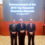
2. Top Research Scientists Malaysia (TRSM)
My Expertise:
ENGINEERING SCIENCES, Geomatics Engineering, Mapping from Space and Remote Platforms
APPLIED SCIENCES AND TECHNOLOGIES, Aerospace, Remote sensing
ENVIRONMENTAL SCIENCES, Environmental Issues and Assessment, Remote Sensing and GIS Applications
INFORMATION, COMPUTER AND COMMUNICATION TECHNOLOGY (ICT), Signal Processing, Image processing and computer vision.
You can find me on:
Email: mazlan@utm.my
https://people.utm.my/mazlanhashim/
- TAHNIAH DIATAS KENAIKAN PANGKAT KE PROFESOR (VK5)
- Top 2% Scientist
- Prof Sr Dr Mazlan Hashim awarded recipient of TRSM 2016 for outstanding contribution in Advancing Remote Sensing Technology
- Prof Sr Dr Mazlan Hashim awarded recipient of TRSM 2016 for outstanding contribution in Advancing Remote Sensing Technology
- Administrative Experiences
Copyright © 2025 Prof. Sr. Gs. Dr. Mazlan Hashim FASc · Genesis Theme Framework


