Reservoir Engineering is a branch of petroleum engineering that applies scientific principles to the drainage problems arising during the development and production of oil and gas reservoirs so as to obtain a high economic recovery.
Objectives Reservoir Engineering
To continuously monitor the reservoir and collect relevant data and interpret it to be able to
determine (present conditions)
estimate (future conditions) and control the movement of fluids through the reservoir so that we can: enhance ( increase recovery factor)
accelerate ( increase production rate) the oil recovery.
What is reservoir?
Reservoir is that portion of a trap which contains oil and/or gas as a single hydraulically connected system.
it is a rock layer
porous so that stores oil
permeable so that allows flow of oil
has a mechanism to prevent escape of oil (trapping mechanism)
Geological FieldWork (GFW) is a practical work done in the field, in groups and supervised by lectures. The lecturer serves as Supervisor.
The supervisor is responsible for designing the visiting schedules after identifying the stations of observation. To faciliate his task in the field, the participants (students) are divided into several groups depending on the total number of students and supervisor’s own direction. For each group, one participant will be selected as a Captain. Therefore, every individual does not work only to satisfy his own needs but also , to cooperate with his Captain and to actively contribute for the benefit of his group.
This fieldwork carried out in the East Coast of Peninsular Malaysia. The fieldwork begins from UTM JB and going through Besut, Kuala Terengganu, Kuantan, Muadzam Shah, Kota Tinggi and finished at UTM JB.
OBJECTIVES
a) To introduce a various of local rock types, geological features, geomorphology and structure
b) Students be able to make basic work in the field (geological compass measurements, field notes, physical rock description and identification, outcrop sketches, sampling).
c) Students know the aims and significance of geological fieldwork in basic and applied geology.
d) To know the rules of field work documentation.
WHAT TO DESCRIBE ON TO NOTE DOWN?
the answer is, the geology and is related features.
a) Types of rocks :Name of rocks? colour? texture?
Mineral contents :Identify all minerals (as far as possible) contained in rock. The texture of each mineral; colour, size, shape (for example, sheet form, etc).
b) Structures :Bedding? Thickness of each layer? S/D bedding planes?
c) Folds :If any; name of fold S/D limbs of fold, bearing of fold axis?
d) Faults :If any? S/D fault plane? Estimate the displacement. Evedance of faulting.
e) Joints :S/D joints planes.
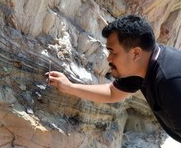
Every photo must have scale. The photo should be an object of known size; like geological hammer; car, people, etc. Geological hammer is a standard tool used by geologists; its standards length is 12”.
MOST IMPORTANT! ENJOY!
STATION/LOCALITY TELUK CEMPEDAK: FINISH YOUR TASK BEFORE SUNDOWN.