Monthly Archives: July 2021

MYBANTU WEEKLY DATA UPDATE

MYBANTU WEEKLY DATA UPDATE

As usual, in addition to data checking done daily, data cleanup is done periodically. Data cleanup is done to prevent repeated/overlapping assistance from occurring.

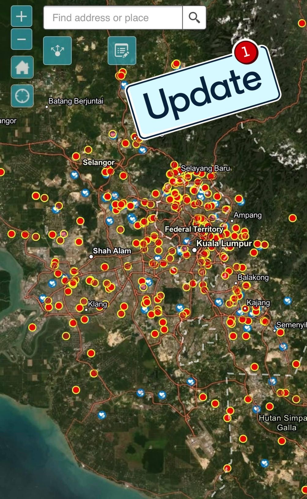
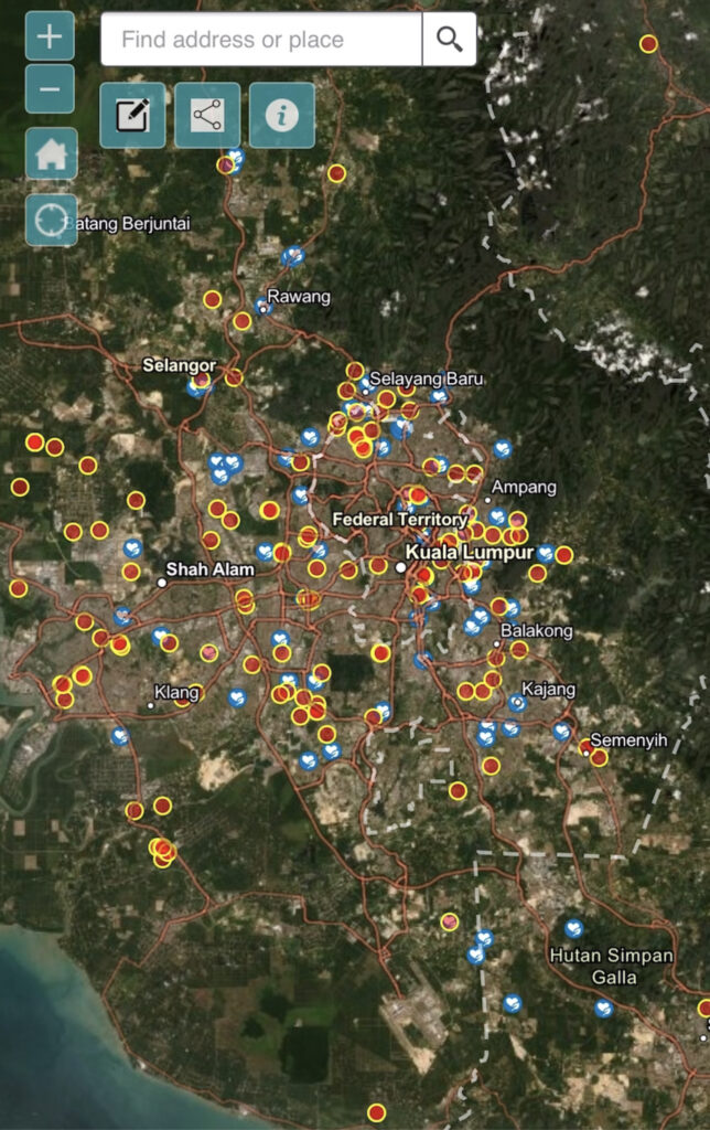
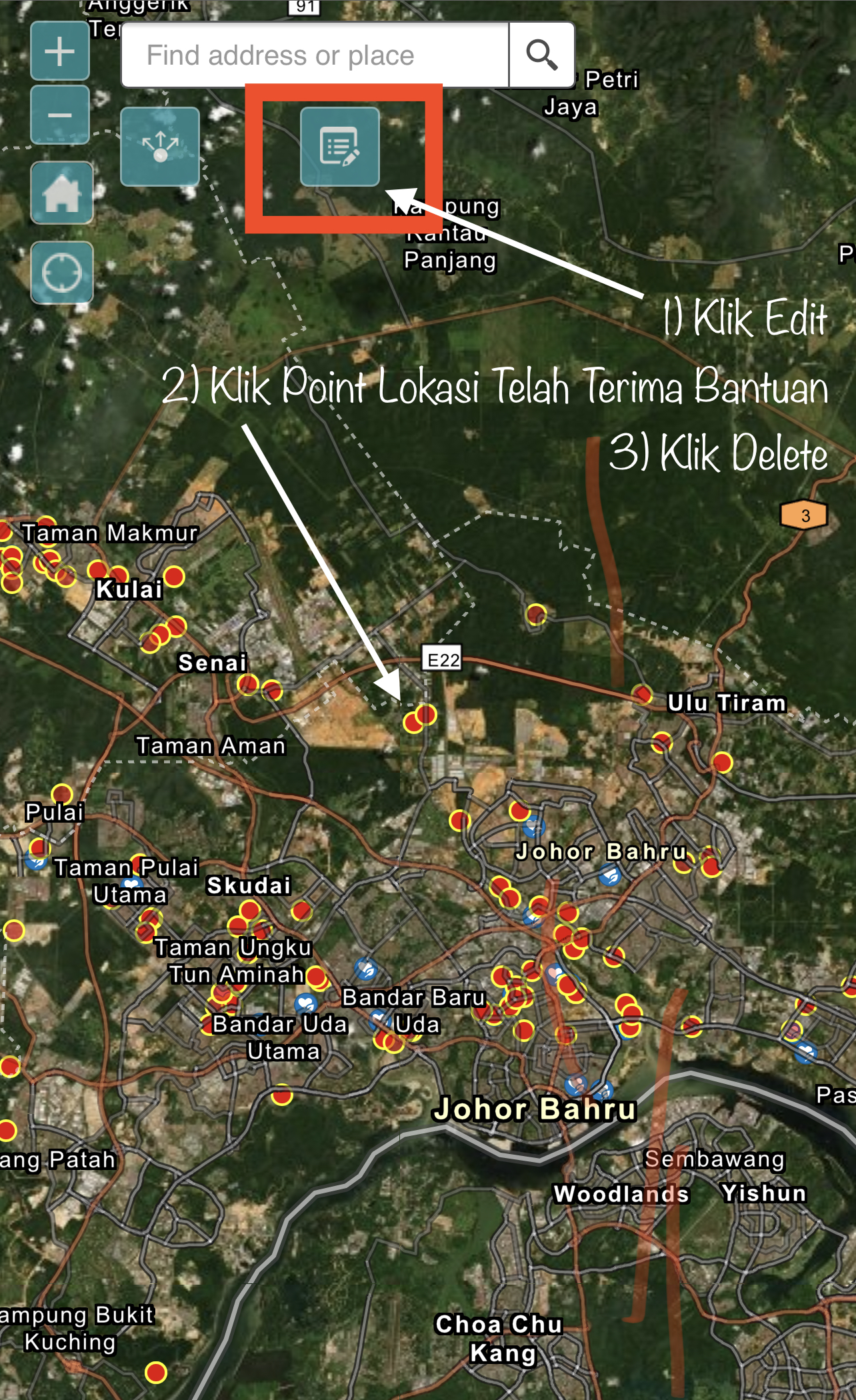
Based on this week’s myBantu map, almost half (47%) of the locations that need help managed to receive help. Especially in the northern part of the Peninsula and in Sabah and Sarawak. Thank you Malaysians who care, provide assistance to those in need.

However, this week’s myBantu map also recorded a higher increase in daily reports compared to the previous week. Hopefully this report will decrease and more Malaysians can be helped.

Since this information can be updated by users, hopefully locations that have received help or “suspicious” can be edited or deleted. Only the locals will be able to do the verification.

To Malaysians who need help, you can fill out the form at this link https://arcg.is/1mK5zn0.

To those who want to donate, click here https://bit.ly/3qH04qu to view the myBantu map.

#malaysiabantu #mybantu #DariRakyatUntukRakyat #kitajagakita #benderaputih #foodbankmalaysia

ITN MALANG LECTURE SESSION

ITN MALANG LECTURE SESSION

I was so excited with the involvement of students from the Geodesy program at the Malang National Institute of Technology, Indonesia. Everything went smooth with the lecture. 

After the lecture, the questions from the students of the Geodesy program were very astonishing. Among the questions are:

  1. Can GIS be applied in the field of Epidemiology?
  2. What is the accuracy of the data required for a GIS system?
  3. Can GIS help in crime analysis works?
  4. How is geodesy handy in GIS?
  5. Is it possible that GIS can be used at the national level?
  6. Can GIS be used for forestry?
  7. What about GIS with air traffic control management?

The answer is yes. I explain by showing real examples that happens in Malaysia as well as my own experience of involvement in those areas.

Thank you to the excellent students from the institute who asked these questions. The names of the students were Jose, Alexandra, Rashid, Aninda, and Gose (sorry I can’t remember the rest).

Keep on going learning new knowledge. Hopefully we have the opportunity to meet here in UTM.

#itnmalang #lecture #gis #3dgis #invitedspeaker #pemateri #geodesy #malang #utm #indonesia #geographicinformationsystem  #geographicinformationscience #gistechnology

MALANG NATIONAL INSTITUTE OF TECHNOLOGY, INDONESIA – LECTURE SERIES 

MALANG NATIONAL INSTITUTE OF TECHNOLOGY, INDONESIA – LECTURE SERIES 

Sharing an info. I have been invited to deliver a lecture series on Geographic Information Science (GIS) at Malang National Institute of Technology, Indonesia.

The interesting thing about the pandemic is that we don’t need a passport or air tickets to travel. Everything is virtual.

Thank you to the organizing committee for inviting and giving me the opportunity to share some of the knowledge I have to the geodesy students there.

“Sharing is good, and with digital technology, sharing is easy.” – Richard Stallman

#lectureseries #itnmalang #malang #gis #gist #gisc #utm #lecture #highereducation #sharingknowledge #geodesy

MYBANTU WEB APP – DATA UPDATE

MYBANTU WEB APP – DATA UPDATE

myBantu map have recorded thousands of data that have been submitted by individuals in need. But it is believed that there are locations that received assistance but is not been edited (updated).

Therefore, the myBantu map will go through a data updating process to avoid duplication of assistance. Since this update process is done in batches, there is a possibility that there will be locations marked as “received assistance”, but it is otherwise. Double check is needed.

Individual who are in needs, make yourself visible by filling out the myBantu form https://arcg.is/1mK5zn0

NGO or individuals who wish to give a hand, you may refer to the myBantu map https://bit.ly/3qH04qu

myBantu #malaysiabantu #darirakyatuntukrakyat

Malaysia Bantu (myBantu) Campaign

Malaysia Bantu myBantu Campaign

Based on the myBantu map, more and more locations have been assisted and the number of myBantu red dot locations is decreasing. Thank you to the caring citizens of Malaysian.

Undoubtedly there are still new locations (that need help) added every day. And this myBantu map is updated in real time.

For those who need help with basic needs, you can fill out this form https://arcg.is/1mK5zn0.

For those who want to help, do check out the myBantu map here https://bit.ly/3qH04qu.

Together we stand strong as Malaysian. 

#myBantu #benderaputih #MalaysiaBantu

GSCAEE 2021 Keynote Talk – DONE

GSCAEE 2021 Keynote Talk – DONE

It was a pleasure to team up with other keynote speakers at the Global Summit of Civil, Architecture, and Environmental Engineering 2021 (GSCAEE2021).

Here are the speakers during my keynote session:

Title: Structural Fire Engineering: A Growing Need for Innovation.
Cristian Maluk, The University of Queensland, Australia

Title: Deep learning and its Applications in Construction.
Mehrdad Arashpour, Monash University, Australia

Title: Recent Trends of 3D City Modeling in Built Environment.
Uznir Ujang, Universiti Teknologi Malaysia, Malaysia

Title:Innovative Strategies for Enhancing Fire Performance of High Performing Materials and Structural Systems.
Venkatesh Kodur, Michigan State University, USA

Title: Hurricane Risk Mitigation in a Changing Climate.
Ning Lin, Princeton University, USA

Congratulations and thank you to GSCAEE 2021 organizer The Scientist and MDPI Building Journal for inviting me as a keynote speaker at this summit. It is the most well-organized online conference to date.

I was informed next year, GSCAEE 2022 will take place in Copenhagen Denmark. If things go back to normal, I plan to be there. I am excited to visit my old house there again.

#gscaee2021 #keynote #talk #3dcitymodeling #3dgis #barcelona #spain #utm

KEYNOTE TALK – GSCAEE 2021

KEYNOTE TALK – GSCAEE 2021

Colleagues and researchers,

Just to share the link of my keynote talk. Its a keynote talk at the Global Summit on Civil, Architecture, and Environmental Engineering 2021 (GSCAEE 2021) on July 21st, 2021 at Barcelona Spain (01:00pm CEST GMT +1). This event is organized by The Scientistt and MDPI Buildings Journal (Switzerland).

The keynote talk entitled: Recent Trends of 3D City Modelling in Built Environment

https://www.thescientistt.com/civil-structural-environmental-engineering/

Feel free to share this link with your research colleagues.

Many thanks.

#research #3dcitymodeling #3dgis #3ddata #keynotespeaker #gis #builtenvironment #gscaee2021

MYBANTU WEB APP – DATA UPDATE

MYBANTU WEB APP – DATA UPDATE 

myBantu maps have recorded thousands of data that have been submitted by individuals in need. But it is believed that there are locations that have not been updated by individuals who have received assistance.

Therefore, the myBantu map will go through a data update process to avoid duplication of assistance. Since this update process is done in batches, there is a possibility that there will be locations marked as “received assistance”, but it is otherwise.

For individuals in need, do check your location on the myBantu map. If your location has been marked as “received assistance”, do re-fill the myBantu form. Your new information will overwrite previous record.

Individual who are in needs, make yourself visible by filling out the myBantu form https://arcg.is/1mK5zn0

NGO or individuals who wish to give a hand, you may refer to the myBantu map https://bit.ly/3qH04qu

#myBantu #malaysiabantu #darirakyatuntukrakyat 

MYBANTU WEB APP – MAP EDIT

MYBANTU WEB APP – MAP EDIT

Since myBantu map received a lot of assistance from NGOs as well as individuals, and to avoid duplication of assistance, you can delete the assistance location on the myBantu map. Here’s how:

1. Click ‘Edit’

2. Click on the location point where you have received assistance

3. Then click ‘Delete’. That’s all.

The map will be updated in real time. Do refer to the picture below.

To Malaysians who need assistance with basic needs as a result of being affected during the pandemic, can fill out this form (https://arcg.is/1mK5zn0).

For those who want to channel donations, you can check the myBantu map which shows the location of individuals who need help. Click here https://bit.ly/3qH04qu.

#myBantu #MalaysiaBantu

FINAL SESSION – ONLINE VIVA BACHELOR DEGREE

FINAL SESSION – ONLINE VIVA BACHELOR DEGREE

The viva online session for undergraduate students took place yesterday. I’m one of the panel to evaluate the students. I’ve been informed that this is the last online viva session for this semester. I wish to congratulate to the students:

  1. Tay Ming Suan
  2. Nursyahira Azhar
  3. Noridayu Kosni
  4. Niveane Albania

This students is doing their thesis totally 100% remotely due to the pandemic (two semesters). But the results are impressive. Seems it looks not as executed remotely. Congratulations again. Hope to see you again in the future. All the best!

#thesis #highereducation #gis #geoinformatics #utm #universititeknologimalaysia #3DGIS #undergraduate #degree #universitylife #campus #pandemic #mco #remotesupervision