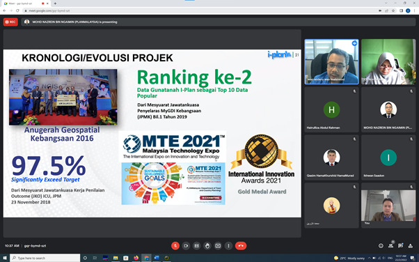
Our recent journal publication in Geomatics and Environmental Engineering Vol. 16 No. 2 (2022).
This article created a new topological intersection model called the 36-Intersection Model for 0 dimension up to 3 dimensional spaces. Feel free to read the article below with tons of new improved mathematical equations (if you don’t mind):
Salleh, S., Ujang, U., & Azri, S. (2022). Representing 3D Topological Adjacencies between Volumes Using a 36-Intersection Model. Geomatics and Environmental Engineering, 16(2), 127–155. https://doi.org/10.7494/geom.2022.16.2.127
Fortunately, I was chosen as one of the Quick-Win Research Grant recipients for 2022. Only 31 research proposal were accepted out of a total of 203 submissions. Approximately 15% proposals granted.
I am highly thankful to UTMSpace for entrusting this project to me. Quick-Win research grant 2022 is a one-year research funding. I was granted RM50,000 and specified KPIs to accomplish.
Today we had a productive discussion with PLAN Malaysia. We’re attempting to determine how we might assist in determining Malaysia’s readiness to realise a smart city.
Thanks to i-Plan Malaysia for the comprehensive explanation as well as a quick overview of the Malaysia Urban Observatory (MUO).
I am thankful to have successfully filed a patent at the Intellectual Property Corporation of Malaysia (MyIPO). My invention is entitled “A 3D Topological Based Cadastral Management System”.
The topology here is not topological error checking for geometric errors, as most researchers commonly understood. On the other hand, it’s the central topology in the Geographic Information Systems (GIS) discipline. Whenever spatial entities exist, they are linked together by distinct mathematical formulas based on their unique interactions.
Browsing through the International Conference on Construction, Structure, and Environmental Engineering 2022 website, I’ve noticed that the keynote presenters at this conference are from all over the world.
I am proud to be the sole representative of Universiti Teknologi Malaysia (UTM) as keynote speaker at this conference. Hope everything goes smoothly and onwards will increase the visibility of UTM’s geospatial field in the eyes of the international community.
My warm welcome to my new PhD student, Usman Mehmood from the National Mapping Agency of Pakistan. We have a productive introductory meeting in the lab with other lab members. All the best!
I’m going to share about how active my courses are during this online learning semester. According to the table, my average “student hits” until week 10 were 5,000.
When divided by the average total number of students, each student accesses my teaching course 20 times per week on average. Students do it voluntarily, and as a result, the Active Index (EL5) for online learning rises to 150 or higher.
The university requested to achieve Active Index = 28. I believe that my achievement of this index can be used as one of the measuring indicators in evaluating the structure of my teaching courses.
During this online learning, I see the need for an approach that can make the teaching material interesting. The lecturer’s value given in the courses will be subconsciously appreciated by the students. Students will voluntarily participate in and enjoy the courses.
Many thanks to the UTM elearning system for providing a reliable platform for managing the courses I teach. It aids lecturers and students in the teaching and learning process.
I’ve completed my responsibilities as an evaluator panel for the undergraduate students. After nearly 5 months of developing a research proposal for their final year project, it is now time for the students to defend their idea.
Various methodologies and student styles can be observed. Hopefully, the suggestions made by the panel can be seen positively and built upon in order to produce higher-quality research outcomes.
INVITED TALK AT LANGKAWI DEVELOPMENT AUTHORITY (LADA)
I was called to deliver a talk on GIS and 3D City Modeling in assisting the management of UNESCO GEOPARK World Heritage at the Langkawi Development Authority (LADA).
The week-long workshop is attended by LADA staff from various departments and backgrounds. LADA staff stated that they only know that GIS can do various experiments and analysis after the talk..
Various questions were asked which shows their curiosity and interest with GIS. Congratulations LADA!