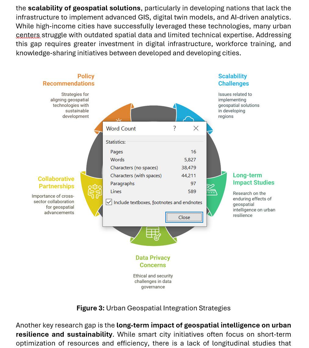
Finally, it’s a wrap! Chapter 4 is done, 5,800 words, 16 pages, and 40 references, completed in just 6 hours. Had to put it on hold on Wednesday, but today I squeezed in 1.5 hours to finish it strong.
This marks a major milestone, 4 book chapters completed in just 2 weeks. It wasn’t easy, but persistence and time management made it happen. One key takeaway: avoid multitasking, focus leads to faster and better results.
Every chapter is a challenge, and every challenge is a step forward. Alhamdulillah for the progress. Now, on to the next one!
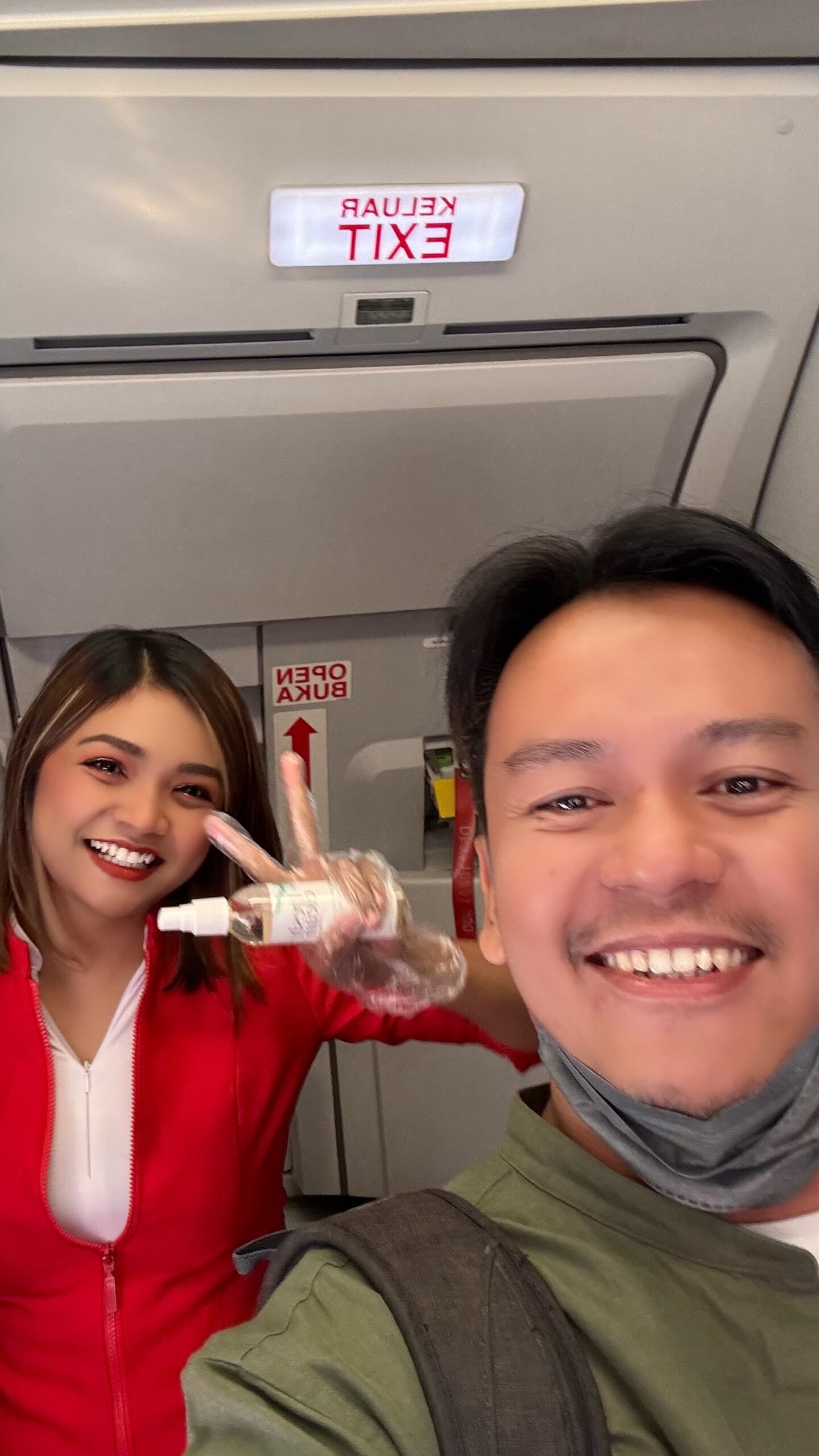
Guess who I met today! 🙂 Erin, one of my former academic advisees. The last time we met was in 2019 when she came to my office to get my signature on her graduation form. Her final question to me was, “Dr., do you think I should continue in GIS or become a stewardess?”. Without hesitation, I answered, “Stewardess”. If my ex-boss (pensioned) knew, they’d probably be mad at me, since I was supposed to encourage her to stay in GIS. But as her academic advisor, I knew Erin personality very well.
Today, I’m so happy to see her thriving. I always wished to bump into her on a flight, but we kept seeing each other from far away at the airport, until today, when we finally ended up on the same flight. Erin even met her soulmate at work, and I got to meet her husband today! Before this, I only saw him in her stories.
Also, I’ve never received a gift on an AirAsia flight (because, well, it’s AirAsia right), but today was a first! My son got a cool AirAsia toy, and we received drinks. Thank you, Erin and your husband. As your academic advisor, I’m so proud of you. Even though you’re now a mother, I still see you as the same bright and youthful Erin from your first year.
Got another journal article for 2025. It’s indexed in the Web of Science and even has a quartile ranking, which is quite decent.
Despite my daily workload and other responsibilities, I make it a priority to write and publish my own journal articles. Lately, I’ve noticed a trend where lecturers rely heavily on students to write journals, and worse, the lecturers end up as the main authors (first in the author name list). It should be the other way around, the students should rely on the supervisor for journal writing.
It’s undeniable that lecturers’ responsibilities are demanding, but academic writing is something that should be done by lecturers themselves, no matter how busy we are.
This journal will take a while to be officially published, scheduled for July 2025, but it’s a strong start to the year. With two high-impact research publications in January 2025, I couldn’t be more grateful.
TEN (10) RESEARCH PUBLICATIONS IN DECEMBER – YEAR 2024 IT’S A WRAP!
This month, we managed to get 10 articles published. As the year comes to a close (aka holidays), I’ll take the time to share the key insights from each paper in the near future. For now, here’s a quick overview of the contributions:
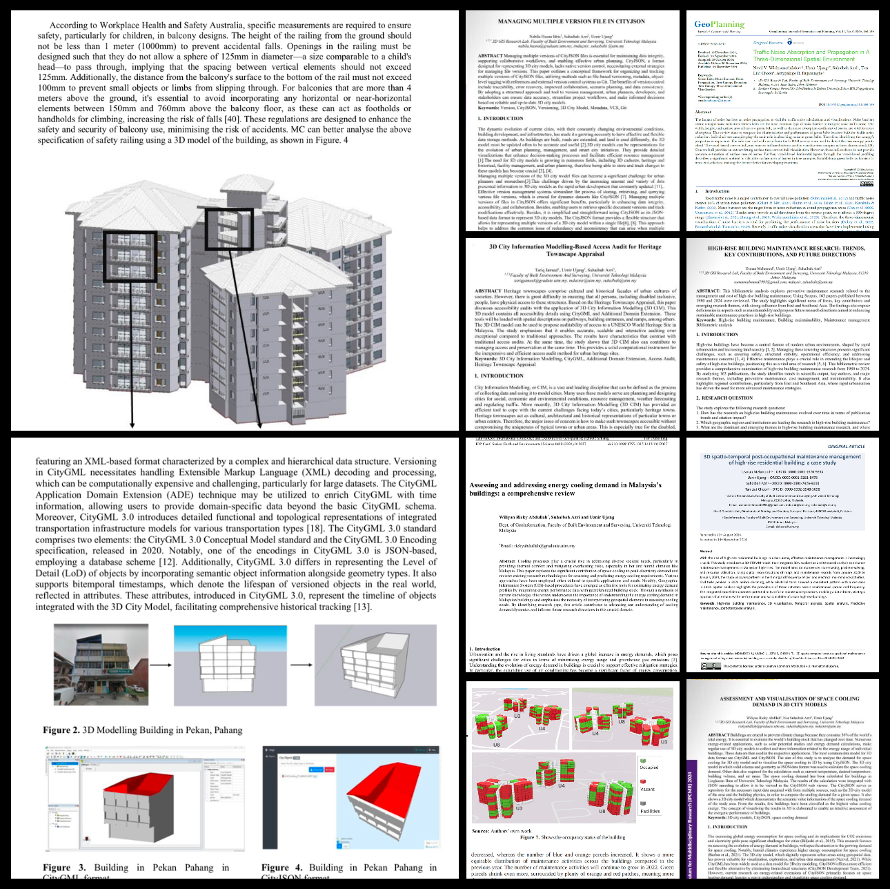
Transforming High-Rise Residential Maintenance: A 3D Spatio-Temporal Model Utilizing Industry 4.0 and Lean Principles .
Traffic Noise Absorption and Propagation in a Three-Dimensional Spatial Environment .
Managing Multiple Version Files in CityJSON .
High-Rise Building Maintenance Research: Trends, Key Contributions, and Future Directions .
3D City Information Modelling-Based Access Audit for Heritage Townscape Appraisal .
Assessment and Visualisation of Space Cooling Demand in 3D City Models .
A Temporal Post-Occupancy Risks Management Model for High-Rise Strata via 3D City Modelling Approach .
Reviewing the Versioning in 3D City Models to Track Building History and Progress .
Assessing and Addressing Energy Cooling Demand in Malaysia’s Buildings: A Comprehensive Review .
3D Spatio-Temporal Post-Occupational Maintenance Management of High-Rise Residential Building: A Case Study
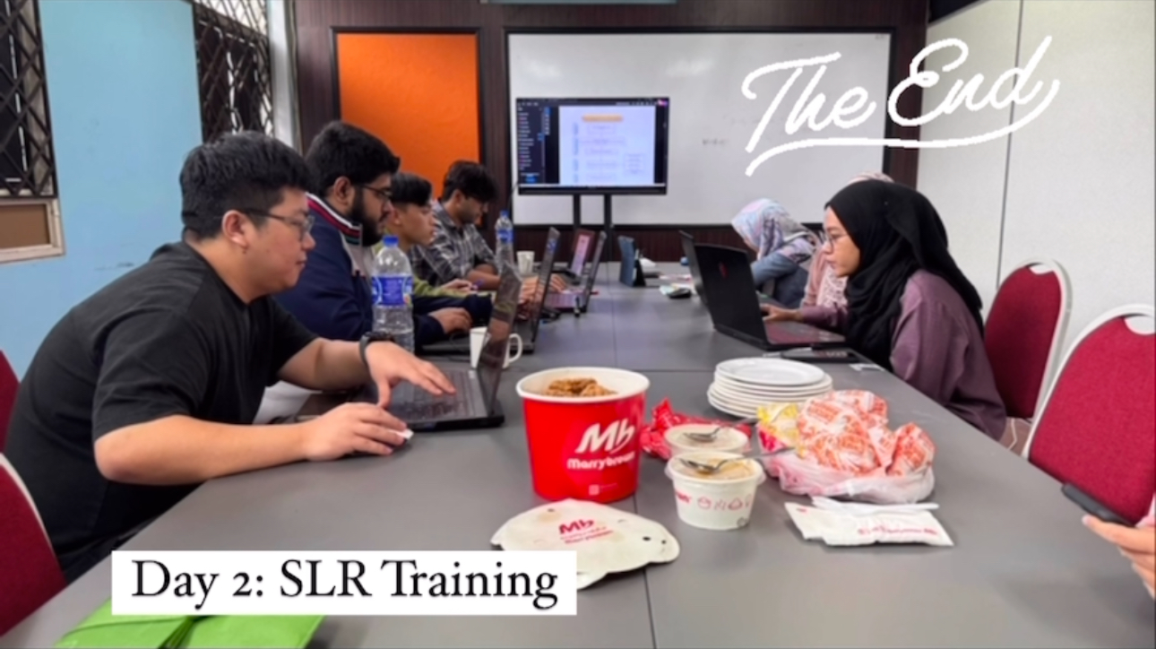
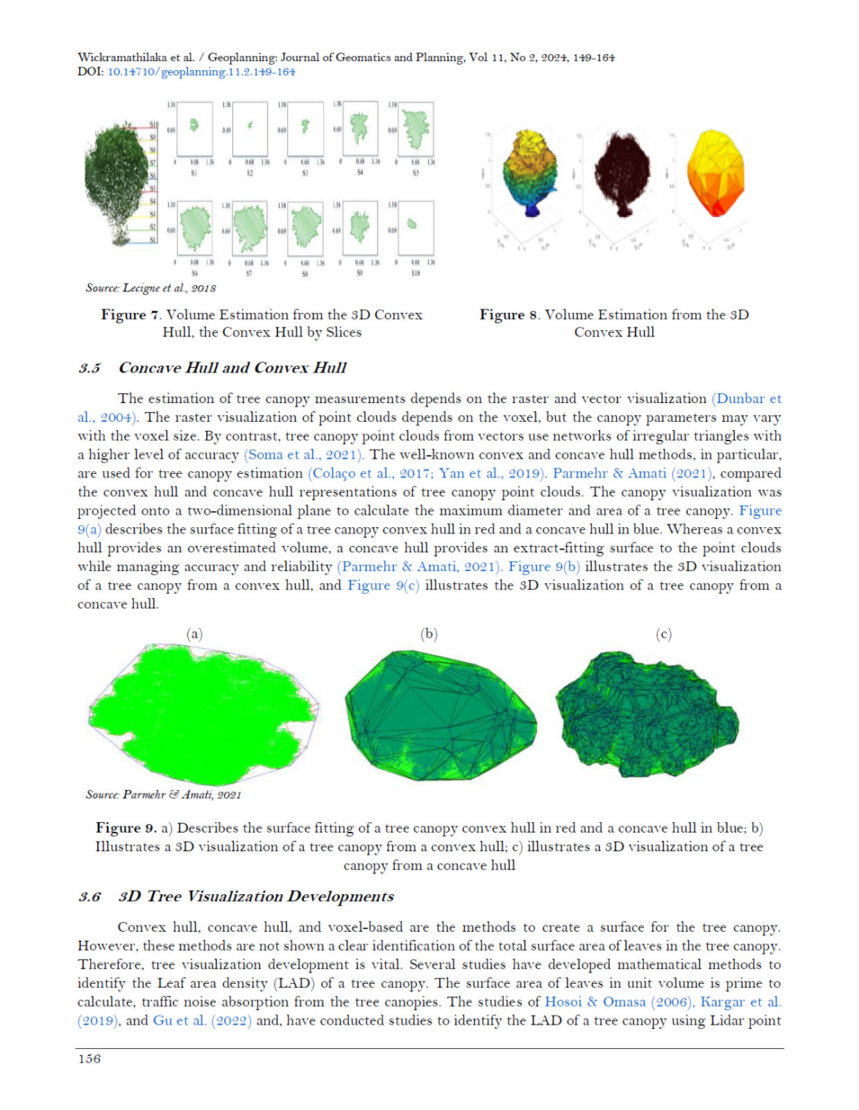
STRENGTHENING RESEARCH SKILLS – SYSTEMATIC LITERATURE REVIEW (SLR) TRAINING DAY 2
Day 2 of our Systematic Literature Review (SLR) training, continuing the journey of building strong research skills within my lab. Led by Hafiz Usman Mehmood, this personal coaching session for lab members focused on advanced techniques and practical applications of SLR.
Key topics covered included:
1. The PRISMA Framework
2. Thematic Analysis & Qualitative Synthesis
3. Structuring Papers & Reporting Results
“The beautiful thing about learning is that no one can take it away from you.” – B.B. King
These sessions aim to prepare our research group to confidently undertake systematic reviews, ensuring their work is rigorous and impactful. It’s rewarding to see the enthusiasm and dedication from everyone involved.
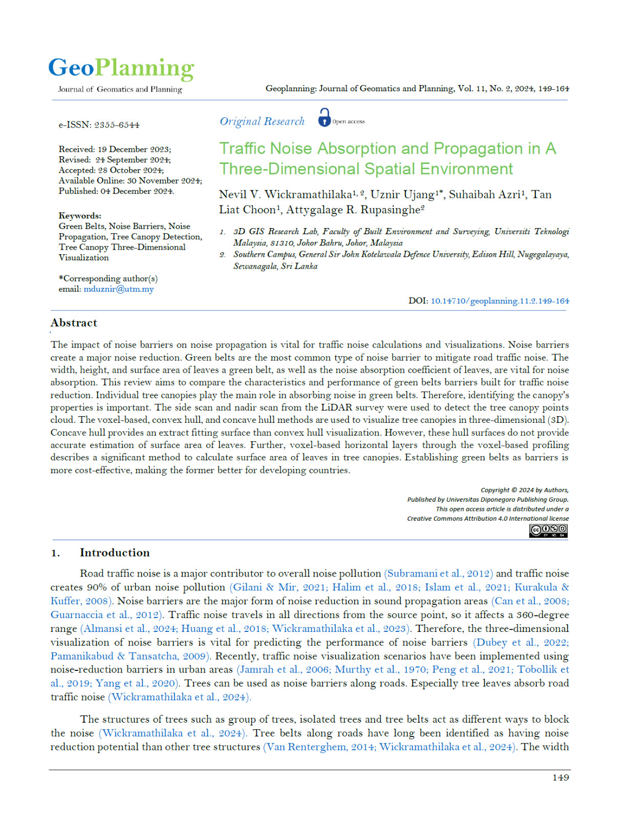
GREEN BELTS IN 3D – A NATURAL SOLUTION FOR TRAFFIC NOISE MITIGATION
This is our latest publication titled “Traffic Noise Absorption and Propagation in a Three-Dimensional Spatial Environment” in Geoplanning: Journal of Geomatics and Planning.
This research explores the role of tree canopies as noise barriers using advanced LiDAR-based 3D models. By visualizing tree structures in 3D, we analyzed their noise absorption performance and identified how green belts can effectively reduce traffic noise propagation.
Okay the Key Findings:
-Tree leaves play a major role in absorbing noise.
STRENGTHENING RESEARCH SKILLS: SYSTEMATIC LITERATURE REVIEW (SLR) TRAINING
On Sunday, we kicked off Day 1 of the Systematic Literature Review (SLR) training session, a personal coaching initiative for my research group. This effort is dedicated to enhancing the research capabilities of my postgraduate students and lab members.
The session, conducted by our very own Lab 3D PhD student, Hafiz Usman Mehmood. He has a vast experience writing this type of paper. Our day 1 training covered critical aspects of SLR, including:
I believe that empowering young researchers with structured approaches like SLR is key to producing impactful, high-quality research.
These closed training sessions reflect our commitment to cultivating a strong research foundation within our lab. Tomorrow, we move to Day 2 with advanced topics, including the PRISMA framework and qualitative synthesis.
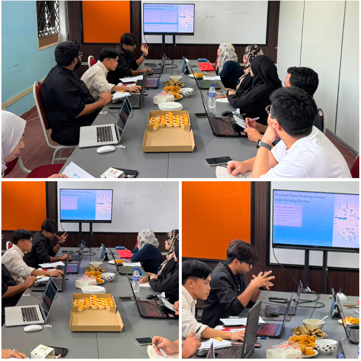
I have been invited to deliver the Keynote Lecture at the International Conference on Water, Environment, Energy, and Society (ICWEES-2025), which will take place on April 24-25, 2025. This invitation came from a research colleague which he is a Vice Chancellor of a university, making it hard to say no.
I am also honored to be invited as a member of the International Technical Advisory Committee for this conference.
This event is jointly organized by the National Institute of Technology Puducherry (NIT PY) and the International Association for Water, Environment, Energy, and Society (IAWEES), in collaboration with institutions like Rabindranath Tagore University, Texas A&M University (USA), and IHE Delft Institute for Water Education (Netherlands).
If anyone here is familiar with this conference or has attended previous editions, please share your insights and experiences. I would love to hear from you!
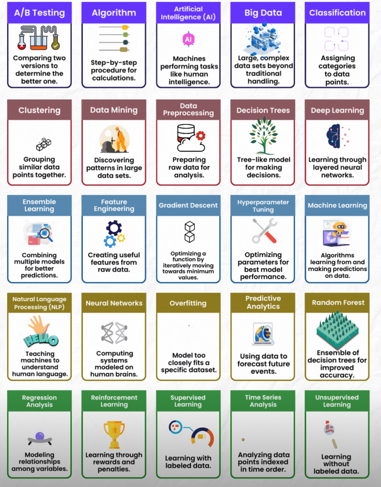
GIS AND DATA SCIENCE – A TWO SIDES OF THE SAME COIN
GIS and Data Science are essentially the same at their core, both involve analyzing and extracting insights from data.
The difference? GIS takes it a step further by adding location to the mix, transforming data into spatial data.
This extra layer of location allows us to visualize patterns, make more informed decisions, and solve complex challenges related to geography, urban planning, environment, and much more.
In other words, GIS = Data Science + Location, unlocking endless possibilities for spatial analysis.
Ready to explore how spatial data enhances traditional data analysis? Dive into these key data science terms that drive both fields forward!
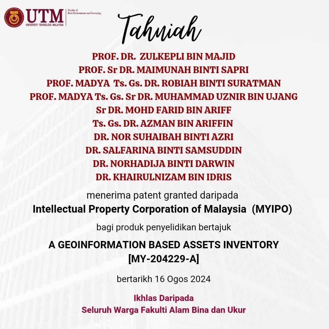
Our team has been granted a patent by the Intellectual Property Corporation of Malaysia (MyIPO) for our research product titled “A Geoinformation-Based Assets Inventory” (Patent No. MY-204229-A). This achievement reflects the hard work and collaboration of an incredible team of experts.
“The only way to do great work is to love what you do.” – Steve Jobs
A huge congratulations to my fellow colleagues:
• Prof. Dr. Zulkepli Bin Majid
• Prof. Sr Dr. Maimunah Binti Sapri
• Prof. Madya Ts. Gs. Sr. Dr. Robiah Binti Suratman
• Prof. Madya Ts. Gs. Sr. Dr. Muhamad Uznir Bin Ujang (They said my name was too long for the banner!)
• Sr Dr. Mohd Farid Bin Ariff
• Ts. Gs. Dr. Azman Bin Ariffin
• Dr. Nor Suhaibah Binti Azri
• Dr. Salfarina Binti Samsuddin
• Dr. Norhadija Binti Darwin
• Dr. Khairulnizam Bin Idris
“Success is the sum of small efforts, repeated day in and day out.” – Robert Collier
This milestone showcases the potential of geoinformation systems in advancing asset management and opens new possibilities for future applications. Let’s keep pushing the boundaries of innovation!
Thank you to Fakulti Alam Bina dan Ukur and everyone who supported us in this journey. Onward to more innovations!