Iskandar Puteri, 16 Januari 2023- The students from the Faculty of Built and Surveying (FBES) at Universiti Teknologi Malaysia achieved remarkable success in the GIS Competition 2023-Storymap Creator Challenge, a testament to their hard work and dedication. The competition was organized by the Iskandar Puteri City Council in partnership with Faculty of Built and Surveying (UTM), University of Reading, ESRI Malaysia, Malaysian Institute of Planners, and Royal Institute Surveyor of Malaysia, was a highly competitive event spanning a duration of 558 hours of creation time, from December 8th, 2022 to December 31st, 2022.


A total of 32 entries were received in the GIS Competition 2023-Storymap Creator Challenge, comprising two main categories: Nature and Physical Science in Iskandar Puteri and Humanities and Culture in Iskandar Puteri, showcasing the diversity and creativity of the participants. For the first time, the Faculty of Built Environment and Surveying (FBES) proudly sent 27 teams of students representing three main programs: Urban and Regional Planning Program, Geoinformation Program and Landscape Architecture Program, marking a significant achievement on the remarkable talent of FBES students.
At the prize-giving ceremony presided over by the Mayor of Iskandar Puteri City Council, Dato’ Haji Mohd Haffiz Bin Haji Ahmad; the students achieved outstanding success by winning a total of 1 Gold, 2 Silver, 2 Bronze, and 4 Special Mention Awards, with total prize money of RM7,800.00.

The students have successfully utilized their Geographic Information Systems (GIS) skills and the data provided by the OneMBIP portal to generate compelling and unique story narratives. Through the integration of GIS techniques and data analysis, the students were able to creatively explore and showcase the information in a new and engaging way. The resulting narratives not only demonstrated a strong understanding of GIS concepts but also highlighted the power of GIS in storytelling and communication.

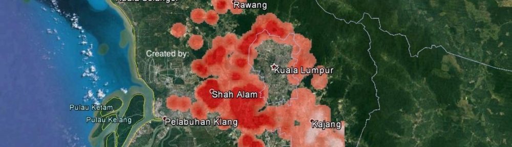
The integration of dashboard displays from big data sources into the storymap not only enhances the overall visual appeal but also allows students to showcase their skills in data visualization. The use of real-world data in a dynamic and interactive format provides a more engaging and meaningful learning experience for students. It also allows them to apply the concepts they have learned in a practical and relevant way, which can deepen their understanding of the subject matter. Additionally, the ability to analyze and interpret large data sets can be valuable in many industries, making this an essential skill for students to develop.

Further, the students demonstrated their ability to effectively utilize sentiment analysis techniques by analyzing social media big data sources to understand public sentiment towards a specific issue or product. This task required them to not only extract relevant data from various platforms but also to perform text preprocessing and cleaning feature extraction, and sentiment classification. The outcome of this exercise gave them a deeper understanding of how people feel about the specific subject matter and how to interpret the results. The ability to conduct sentiment analysis is a valuable skill, particularly in today’s digital age where social media is a primary source of information and opinion. This skill can be used in various fields such as marketing, politics, and customer service, and provides a valuable perspective on the public’s perception of a product or issue.

We hope that the successful partnership between UTM and Iskandar Puteri City Council will continue in the future. We are deeply grateful for their support and generosity of them in fully funding the prize for this competition. Their contribution has been instrumental in making this event a success and providing students with an enriching learning experience. We look forward to further collaboration and opportunities to work together to achieve common goals in the future.
It is important to acknowledge the tireless effort and dedication of TPr Chew Lee Ting and her team in meticulously planning and executing this competition. Their hard work and commitment to ensuring a smooth and successful event cannot be overstated. Their dedication and attention to detail are truly commendable, and we are grateful for their contributions.
We extend our utmost gratitude and appreciation to the advisors who have provided guidance and oversight throughout the competition. Their support and expertise were significant in ensuring that the student’s work was of the highest quality and met the necessary standards. Their contributions are deeply valued and we thank them for their invaluable support:
Urban and Regional Planning:
Ts Gs Dr. Noradila Binti Rusli
Ts Gs. Noordini Binti Che’man
TPr. Gs Dr. Nafisa Binti Hosni
Prof. Dr. Mohammad Rafee Bin Majid
Dr. AK Mohd Rafiq Bin AK Matusin
Landscape Architecture:
Gs Dr. Solehin Fitry Bin Rosley
Dr. Janatun Naim Binti Yusof
Dr. Norliza Mohd Isa
Geoinformation
Dr. Suzanna Binti Azmy
Dr. Aimi Binti Musa
Dr. Hafiz Bin Yatim
Congratulation to the winners.
All the storymaps creations can be accessed at https://link.mbip.gov.my/IPGIS-Challenge


 Tahniah semua! Minor correction.