Agent-Based Modeling (ABM)

Agent

Conceptually, in ABM you give instructions to virtual agents that allow the agents to interact. Agents can be animals, tanks, parcels, delivery trucks, or any discrete object. From the resulting decisions and actions of the agents, patterns are created in space and time. Unlike many other modeling techniques that quantify and then re-create the patterns, agent-based models explore the causes of the patterns; the patterns are emergent properties from the individual decisions of the agents.

Agent-based modeling, combined with spatial data, allows you to address a wide array of problems such as the following:

  • Developing corridor connectivity networks for wildlife movement
  • Anticipating potential terrorist attacks
  • Analyzing traffic congestion or producing evacuation strategies
  • Planning for the potential spread of disease such as bird or swine flu
  • Understanding land-use change
  • Optimizing timber tract cutting
  • Exploring energy flow on electrical networks
  • Performing crime analysis to deter future impact

Many phenomena or agents exist and make decisions in, and relative to, space. The location of an agent and its surrounding environment will influence the agent’s decision making. The agent can influence or change the landscape it interacts with. A GIS is a spatial modeling tool that stores, displays, and analyzes data on spatial relationships. A natural synergy exists between ABM and a GIS. Agent Analyst is free, open-source software developed to integrate an ABM development platform—the Recursive Porous Agent Simulation Toolkit (Repast)—within a GIS (ArcGIS). Agent Analyst is a mid-level integration that takes advantage of both modeling environments.

Source: Agent Analyst – Agent-Based Modeling in ArcGIS by Kevin M. Johnston, Esri Press (2013)

Malaysia MIF Format Coordinate Conversion Tool

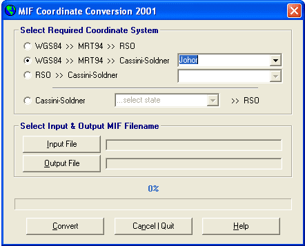
MIF Coordinate Conversion Tool

By Shahabuddin Amerudin

A Valuable Tool for Geospatial Data Conversion

The MIF Coordinate Conversion 2001 tool has proven to be invaluable for geospatial professionals working with MapInfo data in MIF format. This application enables seamless conversion between various coordinate systems, including WGS84, RSO and  State Cassini. The conversions are executed with exceptional precision, ensuring accurate and reliable results.

A History of Development and Use

Originally developed in Microsoft Visual Basic Version 6 in the late 1990s, this tool has undergone continuous improvements over the years to enhance its functionality and performance. Its significance was particularly evident during my academic pursuits at UTM, where it played a crucial role in my Final Year Project (PSM).

Application in Geospatial Research

My PSM project focused on the impact of using multi-data sources in GIS databases from different coordinate systems. Given the limitations of GPS technology at the time, including Selective Availability (SA), the collected GPS data required correction using Differential GPS (DGPS) techniques. The MIF Coordinate Conversion tool was instrumental in this process.

One of the key aspects of the project was evaluating the effectiveness of DGPS in a scenario where the GPS base station was located in Kuala Lumpur and the rover was in Johor Bahru. This study highlighted the challenges of real-time coordinate transformations in GIS software at that time. Many GIS packages struggled to perform accurate conversions due to incorrect parameter usage and unfamiliar transformation formulas.

Conclusion

The MIF Coordinate Conversion 2001 tool has been a valuable asset for geospatial professionals, especially during a time when real-time coordinate transformations were limited. Its ability to accurately convert between various coordinate systems has contributed significantly to the advancement of geospatial analysis and research.

How do Editors look at your paper

When you are doing research you are primarily focused on your hypothesis, methods, test results and research outcome. You are an expert in your research field and are very aware of what others are researching and publishing too. But the actual art of getting your own paper ready for publication requires quite some expertise and a great deal of serious attention and preparation. Please join us for the online lecture:

  • Presentation: Valuable points to take in when you choose a journal and submit your paper
  • Q&A session: with Elsevier’s Executive Publisher Jaap van Harten
  • Moderator: Gwendolyn Holstege, Researcher Relations Manager at Elsevier

https://www.publishingcampus.elsevier.com/pages/210/How-do-Editors-look-at-your-paper.html

Malaysia Coordinate Transformation Program

Malaysia Coordinate Transformation Program

By Shahabuddin Amerudin

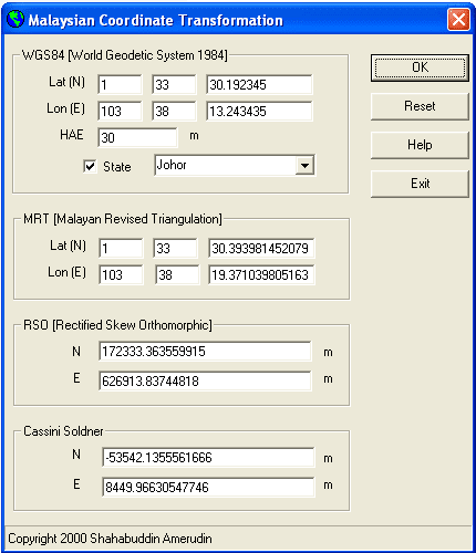
Geographic Information System (GIS) software has significantly advanced the way we approach mapping and spatial analysis, providing essential tools for converting between various coordinate systems. One of the key innovations in this field is the Malaysian Coordinate Transformation Program, developed in 1998 at Universiti Teknologi Malaysia (UTM). This program remains a crucial tool for professionals working with geospatial data in Malaysia. This article offers an in-depth exploration of the coordinate transformation process from the global WGS84 system to the local Malaysian systems, such as the Malayan Revised Triangulation (MRT), Rectified Skew Orthomorphic (RSO), and Cassini-Soldner systems.

Understanding Coordinate Systems and Datums

To appreciate the Malaysian Coordinate Transformation Program, it is essential to understand the coordinate systems and datums involved. The World Geodetic System 1984 (WGS84) is a global coordinate reference system used by the Global Positioning System (GPS). Developed by the U.S. Department of Defense, WGS84 is based on the GRS80 ellipsoid, which approximates the Earth’s shape (National Geospatial-Intelligence Agency, 2014). This system serves as the foundation for most GPS-based navigation and mapping activities worldwide.

In contrast, the Malayan Revised Triangulation (MRT) system is a local geodetic system used specifically in Peninsular Malaysia. Established in the mid-20th century, MRT is based on the Modified Everest ellipsoid, chosen for its suitability to the region’s topography (Ibrahim & Rashid, 1998). MRT was the standard for topographical and cadastral mapping in Malaysia before the widespread adoption of global systems like WGS84.

The Rectified Skew Orthomorphic (RSO) projection is a specialized map projection used primarily for topographical mapping in Malaysia. Developed based on Hotine’s theory in 1947, the RSO projection is an oblique Mercator projection that maintains conformality while minimizing distortion along a selected central line (Hotine, 1947). This projection is tailored for the Malaysian peninsula and is still used in many national mapping projects.

The Cassini-Soldner projection, on the other hand, is a cylindrical and transverse map projection historically used for cadastral mapping in Malaysia. Each state in Peninsular Malaysia traditionally had its own Cassini-Soldner system, with unique origins to minimize distortion within the state (Department of Survey and Mapping Malaysia [DSMM], 1974). Although its use has declined with the introduction of modern systems, it remains significant in historical cadastral records.

Coordinate Transformation Process

The process of transforming coordinates from WGS84 to the Cassini-Soldner system involves several stages. This transformation ensures the accurate integration of GPS data with local surveying systems (DSMM, 1999).

First, the transformation from WGS84 to the local Malayan Revised Triangulation (MRT) system involves the use of the Bursa-Wolf mathematical model. This model accounts for differences in translation, rotation, and scale between datums. The transformation formula can be expressed as:

XMRT=XWGS84+Tx+(1+S)⋅(Rz⋅(YWGS84−Ty)−Ry⋅(ZWGS84−Tz))
YMRT​=YWGS84​+Ty​+(1+S)⋅(Rz​⋅(ZWGS84​−Tz​)−Rx​⋅(XWGS84​−Tx​))

where Tx,Ty,Tz are translation parameters, S is the scale factor, and Rx,Ry,Rz are rotation matrices (National Geospatial-Intelligence Agency, 2014). The MRT system uses the Modified Everest ellipsoid, with specific parameters for semi-major axis and flattening (Ibrahim & Rashid, 1998). Standard algorithms based on the Bursa-Wolf model are applied to carry out this transformation.

Next, the transformation from MRT to the Rectified Skew Orthomorphic (RSO) projection involves applying formulas from the Projection Tables for Malaya. This projection uses the same Modified Everest ellipsoid, ensuring consistency with MRT. The RSO projection system is anchored to specific geographical coordinates in Kertau, Malaysia. Parameters such as central meridian, scale factor, and false easting/northing from the Projection Tables are used to perform this transformation (Hotine, 1947).

Finally, transforming coordinates from RSO to the Cassini-Soldner system involves using the Cassini projection formulas. The Cassini-Soldner projection is cylindrical and transverse, with each state in Peninsular Malaysia having its own specific origins to minimize distortion. The transformation parameters include scale factors, translations, and origin adjustments specific to each state (DSMM, 1974).

The Malaysian Coordinate Transformation Program

Developed in 1998 using Microsoft Visual Basic 6, the Malaysian Coordinate Transformation Program addresses the need for converting coordinates between different systems. Although the program was created on the Windows XP platform, it remains a valuable tool for professionals working with older datasets recorded in these local systems. The program provides a one-way transformation capability, allowing users to convert coordinates from WGS84 to MRT, RSO, and Cassini-Soldner. It also supports state-specific Cassini-Soldner coordinate retrieval, making it highly relevant for land surveying, GIS mapping, and navigation.

Despite its age, the Malaysian Coordinate Transformation Program remains remarkably user-friendly, efficient, and effective. It stands as a testament to the lasting influence of early GIS technologies on contemporary geospatial practices in Malaysia. During the late 1990s, many GIS software solutions available at that time struggled with accurate coordinate transformations due to their lack of specific Malaysian transformation parameters, often relying instead on universal formulas that were inadequate for local requirements. The Malaysian Coordinate Transformation Program, developed with an understanding of these local nuances, provided a vital solution where others fell short.

The Malaysian Coordinate Transformation Program remains an essential tool for GIS professionals, offering reliable solutions for coordinate conversion in Malaysia. Its ability to bridge the gap between global and local geodetic systems ensures its continued relevance in integrating historical and modern geospatial data.

For further information or inquiries about this program, interested individuals can contact shahabuddin@utm.my.

Important Notice

This program is not compatible with newer datums, such as GDM2000, and is specifically tailored for earlier geodetic systems utilized in Malaysia. As the program was developed in 1998 using Microsoft Visual Basic 6 and Windows XP, users may encounter compatibility issues when running it on the latest versions of Windows.

References

Department of Survey and Mapping Malaysia (DSMM). (1974). Cassini-Soldner projections for cadastral surveying in Malaysia. Technical Report No. 74-3, Kuala Lumpur.

Hotine, M. (1947). The Rectified Skew Orthomorphic projection of the sphere. The Geographical Journal, 109(2), 97-107.

Ibrahim, M. F., & Rashid, K. A. (1998). Mapping Malaysia: The evolution of geodetic datums and projections. Malaysian Surveyor, 33(4), 22-35.

Department of Survey and Mapping Malaysia (DSMM). (1999). GPS cadastral survey guidelines Semenanjung Malaysia. Retrieved from https://www.jupem.gov.my/jupem18a/assets/uploads/files/pekeliling/a9684-sg-699.pdf

National Geospatial-Intelligence Agency. (2014). World Geodetic System 1984 (WGS84) Implementation Manual. Retrieved from https://www.nga.mil


Announcement

We are pleased to announce that the program, now over 25 years old, has benefited numerous users since its initial release. Many users have reached out to me directly via email for assistance, and I have been glad to support them. To make things more convenient, I am now offering this program to the public for free. Those interested can download it from the following link: http://bit.ly/2F6O1ZS. However, please review the following important information before using the program:

Geodetic Datum Support

This program was developed in 1998, based on the geodetic datums available at that time. Therefore, it may not support newer geodetic datums, such as GDM2000, or other recent updates in geospatial reference systems. If your work requires the use of modern datum systems, you may need to use alternative software that accommodates the latest requirements.

Windows Compatibility Issues

The program was created using Microsoft Visual Basic 6 for use on Windows XP, and as such, it may encounter compatibility issues when running on more recent versions of Windows, such as Windows 10 or Windows 11. If you encounter difficulties, here are a couple of solutions:

  1. Install missing libraries: Some required system components, such as the mscomctl.ocx library, may not be included in newer versions of Windows. To resolve this, you can follow the instructions provided here: https://www.windows10free.com/repair-how-to-install-mscomctl-ocx-missing-windows-10/.
  2. Manually download the mscomctl.ocx file: If the issue persists, you can manually download the mscomctl.ocx file from https://thegeekpage.com/mscomctl-ocx/ and follow the provided steps to register it on your system.

Legal Disclaimer

While this program is now freely available to the public, we do not provide any official support or updates. The program is distributed on an “as-is” basis, with no warranties of any kind. By using the program, you acknowledge that we are not liable for any inaccuracies, errors, or damages that may result, particularly given the program’s age and the potential for compatibility issues with modern operating systems.

We hope the program proves useful to you. Please use it responsibly and at your own discretion.

Sunday, Oct. 6, 2024

Advanced Research in Geoinformation and Real Estate Vol. 2

Vol 73, No 5 (http://www.jurnalteknologi.utm.my/index.php/jurnalteknologi/issue/view/168)

Advanced Research in Geoinformation and Real Estate Vol. 2

Chief Editor: Mat Naim Abdullah@Mohd Asmoni  Editorial Boards: Zulkepli Majid, Robiah Hj. Suratman, Khairulnizam M. Idris, Shahabuddin Amerudin, Janice Lee Yim Mei, Abd Wahid Rasib

Table of Contents

Science and Engineering

Environmental Hostility Contingencies on the Relationship between Knowledge Management Strategy and Firm Performance PDF
Alizar Hasan, Abdul Hakim Mohammed, Wardi Wardi, Nursyaifi Yulius, Heldi Heldi, Mat Naim Abdullah
Service Level Agreements: Governance in Outsourcing Facility Management PDF
Armai Mohamed, Abdul Hakim Mohammed, Mat Naim Abdullah
The Interpretations of Gated Communities from the Malaysian Gating Experience PDF
Ainur Zaireen, Z, Hussin, K., Maslinda, A. L., Norhidayah, M. Y., Razali, M. N., Noorsidi Aizuddin, M. N., Mohammed, A. H., Siti Radiaton Adawiyah, Z.
Exploring Critical Success Factors of Energy Management for Sustainable Building in Malaysian University PDF
Alia Abdullah Saleh, Abdul Hakim Mohammed, Mat Naim Abdullah
Assessment of Forest Encroachment Using Remote Sensing Technique. Case Study: Mentigi Forest Reserve, Cameron Highlands PDF
Mohd Hayyi Mat Zin, Baharin Ahmad
Applications and Sustainability in Groundwater Abstraction in Malaysia PDF
Intan Sazrina Saimy, Fauziah Raji
GeoPackage as Future Ubiquitous GIS Data Format: A Review PDF
Muhammad Hanis Rashidan, Ivin Amri Musliman
Comparing Shoppers’ Perception in Image Dimensions: A Retail Case Study PDF
Janice YM Lee, Wee Zhao Yuan, Mat Naim Abdullah @ Mohd Asmoni, Rohaya Abdul Jalil, Maizan Baba
Housing Bubble in Penang Prediction and Determinants PDF
Loh Yun Lu, Janice YM Lee, Usama Al-mulali, Nurul Afiqah Ahmad, Izran Sarrazin Mohammad
Stock Market Reaction to Corporate Real Estate Divestitures and Acquisitions during the Global Financial Crisis PDF
Annie Wong Ping Eng, Janice YM Lee, Muhammad Najib Mohamed Razali, Mat Naim Abdullah @ Mohd Asmoni, Izran Sarrazin Mohammad
Child Safety Policy in High-Rise Building as Preventive Measures of Child Falls–A Review PDF
Sitiayu Zubaidah Yusuf, Khadijah Hussin, Nur Husna Azali
An Overview of Green Retrofitting Implementation in Non Residential Existing Buildings PDF
Rehmaashini Jagarajan, Mat Naim Abdullah @ Mohd Asmoni, Janice YM Lee, Mohd Nadzri Jaafar
Evaluation Criteria of Safety and Health Induction for Construction Worker (SICW) in Malaysia PDF
Alfred Goh Pui Teck, Mat Naim Abdullah @ Mohd Asmoni, Hamdi Abdul Hamid, Mohd Saidin Misnan, Janice YM Lee, Mohd Nadzri Jaafar
Impacts of Indoor Environmental Quality (IEQ) Elements on Residential Property Market: A Review PDF
Asmma’ Che Kasim, Megat Mohd Ghazali Megat Abdul Rahman, Maryanti Mohd Raid
Variations of Sea Level and Tidal Behaviour during El Nino/La Nina: An Example of Malaysian Coastline PDF
Mohd Hilmi Abdullah, Mohd Razali Mahmud, Nor Ainah Amat
Parameterization of Aerodynamic Roughness Length and Zero Plane Displacement Over Tropical Region Using Airborne LiDAR Data PDF
Muhammad Zulkarnain Abdul Rahman, Faiznor Farok, Abd Wahid Rasib, Wan Hazli Wan Kadir
Individual Tree Measurement in Tropical Environment using Terrestrial Laser Scanning PDF
Muhammad Zulkarnain Abdul Rahman, Zulkepli Majid, Md Afif Abu Bakar, Abd Wahid Rasib, Wan Hazli Wan Kadir
Local Authorities Challenges in the Implementation of Maintenance and Operation Blueprint PDF
Norhidayah, M. Y., Khadijah, H., Maryanti, M. R., Ainur Zaireen, Z., Maslinda A. L., Razali, M. N., Noorsidi Aizuddin, M. N., Abdul Hakim, M., Siti Radiaton Adawiyah, Z.
The Need for Land Use Assessment in Enhancing the Implementation of Integrated Water Resource Management (IWRM) PDF
Anis Syazwani Sukereman, Robiah Suratman, Chang Wai Sin
Performance Determinants of Malaysian Real Estate Investment Trusts PDF
Rohaya Abdul Jalil, Hishamuddin Mohd Ali
Conceptual Design of Malaysia Geopostcode System PDF
Wan Mohamad Nazmeen Wan Othman, Zainab Mohamed Yusof, Shahabuddin Amerudin
Accuracy Assessment of LIDAR-Derived Elevation Value Over Vegetated Terrain in Tropical Region PDF
Zamri Ismail, Muhammad Zulkarnain Abdul Rahman, Mohd Radhie Mohd Salleh, Abdul Razak Mohd Yusof
Spectral Variability Analysis of In-Situ Hyperspectral Remote Sensing at Leaf and Branch Scales for Tree Species at Tropical Urban Forest PDF
W. C. Chew, A. M. S. Lau, K. D. Kanniah, N. H. Idris
An Overview of the Forecasting Methods Used in Real Estate Housing Price Modelling PDF
Mohan Munusamy, Chitrakala Muthuveerappan, Maizan Baba, Mat Naim Abdullah @ Mohd Asmoni
Application of the Powers of Governors’ to Charge Ground Rent Under Nigeria Land Use Act of 1978 PDF
Onuoha Iheanyichukwu Joachim, Norhaya Kamarudin, Godwin Uche Aliagha

Bagaimana menjalani kehidupan sebagai pendamping hidup / isteri / suami kepada calon PhD

PhD

Oleh Norfaradina Ab Ghafar

Soalan ini saya tidak pernah dapat dari orang putih walhal sudah bertahun menetap di UK, tapi bila balik berhari raya di Malaysia bertubi-tubi soalan ini hadir. Saya tidak kisah, saya hadiahkan senyuman, warga Malaya memang prihatin. Masha Allah. Bentuk soalan yang selalu mereka tanya, suami awak doktor hospital mana? Doktor bahagian apa? Ada klinik tak?

Begini ceritanya, suami saya bukan doktor perubatan. Suami saya seorang pemegang ijazah doktor falsafah, PhD daripada Imperial College London, pengkhususan beliau adalah Composites Material, suatu cabang Aeronautic Engineering, di negara kita tenaga mahir bidang ini belum ramai lagi.

Alang-alang ni, mari saya kongsikan sedikit pengalaman saya menemani suami saya, Dr. S dalam tempoh beberapa tahun perjuangan dan survival PhD beliau.Selalu kita jumpa tips untuk calon PhD sahaja, bagaimana mahu menulis thesis dalam tempoh tertentu, bagaimana mahu pilih penyelia pengajian yang bagus, bagaimana mahu lulus viva dengan cemerlang, bagaimana mahu tulis thesis yang tidak ditolak oleh penyelia dan lain-lain, tapi hari ini saya mahu kongsi tips tentang : Bagaimana Menjalani Kehidupan sebagai Pendamping Hidup / Isteri / Suami kepada Seorang Calon PhD. Maklumlah, 9/10 calon PhD biasanya orang yang sudah berumahtangga.

1. Ambil tahu perjalanan PhD pasangan, apa research area, sudah berapa jauh research mereka, sudah sampai peringkat apa PhD mereka, proposal, defend proposal, writing, submission, proof reading, correction. Dari sekecil hal seperti hari ini ada meeting group ke, jumpa penyelia ke, sehinggalah hari viva. Lebih-lebih lagi jika calon PhD nya suami, isteri siapkanlah mereka pakaian yang mengikut keperluan. Pada hari berjumpa penyelia biar kemas sedikit, jangan comot-comot. Viva pakai tali leher, pakai blazer. Pergi conference pakaian ikut cuaca tempat yang mahu dipergi. Kalau ke Switzerland bekalkan baju tebal, kalau ke Thailand siapkan baju yang bila berpeluh tidak basah ketiak.

2. Jangan tekan pasangan tentang apa yang dia dan kita tinggalkan demi mencapai impian dia menggenggam PhD. Kadangkala bila pasangan mendapat peluang melanjutkan pengajian sehingga peringkat PhD lebih-lebih lagi PhD di luar negara, kehidupan yang sedia ada sudah agak stabil, sudah berkerja tetap, sudah ada rumah selesa, sudah mampu beli kereta yang dihajati sejak zaman sekolah. Bila mahu ke luar negara segalanya perlu ditinggalkan buat sementara, jika pasangan yang menemani berkerja, perlu mengambil cuti tanpa gaji pula. Belum masuk bab keluarga, ibu bapa yang semakin berusia, kampung halaman, binatang ternakan dan kesayangan serta makanan kegemaran. Sebagai pasangan kepada calon PhD, tidak perlulah mengungkit apa yang kita tinggalkan demi PhD mereka. Anggaplah itu bahagian rezeki keluarga dan perkahwinan yang kita dirikan dengan seorang calon PhD. Orang putih kata don’t pester. InsyaAllah hari ini kita permudahkan urusan pasangan untuk mendapatkan PhD nanti kita pula dipermudahkan urusan kehidupan dan rezeki.

3. PhD bukan fasa bulan madu, jangan tekan pasangan untuk bercuti secara kerap. Orang buat PhD ini busy, mahu cuti pun kena minta dengan supervisor. Yang jenis researchnya melibatkan eksperimen selalunya eksperimen mereka akan dilakukan dalam kumpulan, dari berkongsi hipotesis, calculation, peralatan, mesin hingga makmal. Bila seorang tidak hadir kerja ahli kumpulan yang lain sedikit sebanyak mungkin terganggu juga. Orang kata kalau sudah sampai ke luar negara, berjalanlah. Memang tidak salah, berjalanlah selagi mampu dari segi masa, fizikal, mental, kewangan. Naiklah flight di Gatwick transit di Frankfurt,sambung terus ke Dubai. Ambil Eurostar dari King’s Cross St Pancras sampai Paris sambung naik bas ke Belgium pula. Tapi pastikan jangan ditekan pasangan kita yang sedang menjalani PhD untuk tinggalkan kerja serta merta dan tergendala demi membawa kita jalan-jalan merata. Seperti point nombor 1 , ambil tahu, rancang, dan beri galakan kepada pasangan untuk mereka bersedia demi sebuah percutian yang tenang dan tidak tergesa-gesa serta resah kerana ada kerja yang ditinggalkan tergendala. Kalau tidak berpeluang untuk bercuti ketika pasangan sedang buat PhD tidak mengapa. Lepasan PhD selalunya berpeluang cerah untuk pergi ke serata dunia menghadiri conference, talk, seminar, discussion dan sebagainya. Pengalaman saya, suami saya dahulu berkerja sebagai pensyarah Universiti Sains Malaysia tidak lama, tidak sampai setahun pun, tapi dalam tempoh itu beliau dihantar untuk menghadiri conference di Amerika, visanya 10 tahun, sampai hari ini pun masih ada baki beberapa tahun lagi visa tersebut.

4. Jika ditakdirkan mengandung semasa tempoh PhD jangan berkeluh kesah, sesal dan marah. Memang pernah terdengar terdapat sesetengah penyelia PhD tidak suka seandainya calon di bawah seliaannya mendapat anak ketika menjalani PhD, baik calon lelaki apatah lagi calon perempuan. 2 orang anak saya dilahirkan ketika suami saya sedang melanjutkan pengajian di peringkat PhD, tapi alhamdulillah kami survived, barangkali kerana Allah rezekikan suami saya mendapat supervisor dan groupmates yang baik dan memahami. Namun jika situasi sebaliknya, bertenang. Tahan diri daripada merungut. Kelahiran anak adalah rezeki dari Allah. Dia memberi, pasti Dia sudah ada perancangannya buat kita. Mana tahu anak itulah sumber inspirasi dan penguat kita untuk berusaha gigih menyiapkan PhD yang mana itulah yang mungkin melembutkan hati penyelia apabila melihat kesungguhan kita walaupun berbayi kecil.

5. Maksimakan manfaat dan kebergunaan diri. Contohnya jika pasangan melanjutkan pengajian PhD di UK, dan kita miliki anak dalam usia persekolahan rendah (primary school). Primary school di UK, pelajar dari nursery hingga year 6 tidak dibenarkan pergi dan pulang sekolah tanpa ditemani penjaga. Maka pasangan calon PhD, gunakanlah peluang seperti ini, jalankan tugas-tugas seperti ini sendiri. Belajar gunakan kenderaan awam seperti bas dan tube tidak perlu tunggu sehingga pasangan balik ke rumah dari tempat pengajian untuk membeli barang keperluan. Kuasai bahasa tempatan, pelajari dan fahami sistem setempat supaya pasangan kita yang sedang buat PhD tidak terbeban dengan tugasan kecil yang sepatutnya kita boleh lakukan seperti membawa anak ke pusat kesihatan untuk temujanji dengan health visitor, membawa anak ke playgroup, pemeriksaan kesihatan, booking appointment, terapi dan sebagainya.

6. Jangan bandingkan perjalanan PhD pasangan anda dengan calon PhD lain seperti mengapa orang ini boleh siap PhD 2 tahun, mengapa dia buat PhD lama, mengapa orang ini buat PhD di malaysia sahaja mengapa dia sampai kena pergi ke UK. Mengapa orang ini buat PhD tidak perlu masuk makmal hujung minggu, mengapa dia Sabtu Ahad pun kena pergi ke universiti dan sebagainya. Setiap calon PhD perjalanan PhD mereka tidak sama, research area tidak sama, supervisors tidak sama. Ada orang dapat supervisor yang OK, tidak cerewet, ada orang yang cuma ada seorang supervisor untuk dipuaskan hatinya, ada orang sampai 3 supervisor yang memberi arahan berbeza-beza sampai calon pun pening. Ada orang buat PhD di institusi yang boleh bertolak ansur, ada juga yang dapat supervisor OK tapi institusi tidak flexible, thesis yang disubmit mesti melepasi standard yang tinggi baru boleh viva dan publish.

7. Bantu, sediakan mereka ruang dan peluang berkerja dengan kondusif. Calon PhD tidak terlepas daripada membawa kerja pulang ke rumah. Misalnya, seharian berada di makmal, mereka perlu melakukan eksperimen berulang-ulang kali dari jam 8 pagi hingga 8 malam sehingga mendapat hasil yang memuaskan, maka laporan eksperimen terpaksa dibawa pulang untuk disiapkan di rumah kerana tiada masa untuk disiapkan di kolej. Tugas sebagai pasangan, persiapkan rumah dalam keadaan yang baik supaya mereka dapat buat kerja yang dibawa pulang dalam keadaan sebaik mungkin.

8. Galakkan mereka untuk memperbaiki ibadah, dan mempertingkatkan pengetahuan agama walaupun sibuk dengan tugasan untuk menyiapkan PhD. Di setiap kesibukan dunia, perlu sentiasa ada kesedaran untuk menyeiringkan keperluan akhirat insyaAllah jalan dunia akan dipermudahkan. Dulu, sewaktu saya baru bernikah, waktu itu saya sangat muda,(jarak usia saya dan suami agak jauh, hampir sedekad) biasalahkan darah remaja kerjanya nak emo je, saya pernah terasa merajuk hati apabila orang suka quote nama ustaz popular untuk mengeluarkan kenyataan dan status Fb seperti “Belajar sampai PhD tak guna kalau emak mu mati, baca yasin pun gagap, kalau baca alfatihah pun semput” – Ustaz xyz- tapi sekarang tidak lagi. Saya anggap apa yang diperkatakan ustaz itu urusan dia dengan Allah dan terlahir daripada kekurangan pengetahuan atau pengalaman beliau berdampingan dengan calon atau pemegang PhD. Hakikatnya orang-orang yang buat PhD ini manusia biasa sahaja seperti orang lain yang belajar sehingga darjah 6 atau SPM, seperti lepasan diploma atau degree. Iman mereka ada turun naiknya, ada PhD bukan bermakna mereka terpaksa lupakan huruf hijaiyah, cara mengaji, tajwid dan tartil sampai nak baca alfatihah pun tergagap sebab nak beri satu ruang khas dalam otak untuk tempatkan PhD. Semuanya bergantung kepada individu itu untuk memelihara iman, akidah dan ibadahnya. Kalau dalam hati tidak rasa perlu kepada agama, jangankan belajar sampai PhD, orang tidak sekolah pun boleh lupa cara mengaji.

9. Dengari, selami, fahami rungutan dan kerisauan pasangan kita terhadap pengajian PhDnya. Contohnya jika pasangan kita yang sedang melanjutkan pengajian itu jiwanya jiwa orang berniaga, dalam hatinya ada dilema untuk berniaga atau melanjutkan pelajaran. Sejukkan hatinya dengan pengertian dan kefahaman bahawa pencapaian pelajarannya juga adalah suatu maslahah buat ummah. Agama juga perlu kepada pakar-pakar Islam. Bukan semua orang punya peluang, ruang dan kelebihan dari segi kebolehan belajar dan daya intellectual seperti dia untuk menyambung pengajian sehingga PhD. Ia menjadi fardhu kifayah kepada mereka untuk mendalami sesuatu bidang.

Analoginya mudah, bumi Mekah perlu dibangunkan untuk menampung jumlah jemaah yang meningkat saban tahun, sampai bila mahu bergantung kepada jurutera, pakar pembinaan dari Jerman, Sweden dan Holland.

Analogi kedua, umat Islam perlukan ubat-ubatan yang halal 100%, ahli farmasi perlu melanjutkan pengajian sehingga PhD untuk membuat kajian, mendapat geran penyelidikan untuk mencipta dan memasarkan ubatan dan makanan tambahan yang bagus, selamat dan suci.

Analogi ketiga, sistem perbankan yang sedia ada di dunia ini sudah tepu kapitalis, kita perlukan pakar kewangan islam yang mendalami selok belok kewangan dunia, dengan sijil yang diiktiraf dari pusat pengajian yang diiktiraf supaya hasil penyelidikannya dalam bidang tersebut dapat dibentangkan dan didengar oleh dunia. Dalam konteks ini mungkin ada orang boleh berkata, “Ahh setakat nak buat kajian pasal sistem duit aku boleh buat dekat rumah tak payah ada PhD”. Benar, kita semua bijak, Allah bagi kita akal, kita boleh kaji, boleh study, boleh siasat, kita boleh lakukan penyelidikan secara underground, tapi penyelidikan secara underground seperti ini, kesudahannya mungkin dalam blog, dalam FB dan ebook sahaja. Bagaimana hasil kajian kita itu dapat didengar, diketahui dan dipertimbangkan sekiranya tidak berada di platform yang betul. Sebab itu kita perlukan pakar-pakar islam yang melanjutkan pengajian ke peringkat yang tinggi, mendalami satu-satu bidang sehingga dianugerahkan sijil yang diiktiraf dari institusi yang diiktiraf, supaya suara, hasil kajian, idea dan kebijaksanaan orang islam dapat dibentangkan, diketahui oleh dunia, disebarkan, dimulakan gerak kerja untuk melaksanakannya, dan dapat memberi manfaat kepada ramai orang islam lain seterusnya mengubah sistem tidak islamik yang sedia ada kepada sistem Islam yang lebih baik hasil daripada penyelidikan yang dilakukan oleh orang Islam sendiri.

Sebenarnya perkara di atas juga applicable kepada pasangan kepada orang berkerjaya, pasangan kepada orang yang masih belajar (master, degree, diploma, sijil, ACCA dll), pasangan jarak jauh dan sebagainya. Twist sini, ubah sana, adapt situ. Hidup ini ada banyak pilihan, ada banyak jalan, tinggal terserah kepada kita sahaja bagaimana mahu memanfaatkannya untuk menuai hasil terbaik yang dapat menjadi saham akhirat kelak insyaAllah.

Advanced Research in Geoinformation and Real Estate Vol. 3

Vol 75, No 10 (http://www.jurnalteknologi.utm.my/index.php/jurnalteknologi/issue/view/194)

Advanced Research in Geoinformation and Real Estate Vol. 3

Chief Editor: Shahabuddin Amerudin  Editorial Boards: Zulkepli Majid, Robiah Hj. Suratman, Khairulnizam M. Idris, Mat Naim Abdullah@Mohd Asmoni, Janice Lee Yim Mei, Abd Wahid Rasib

Table of Contents

Science and Engineering

A PROPOSAL FOR A SINGLE TRIBUNAL OF ESTATES DISTRIBUTION IN MALAYSIA PDF
Fatin Afiqah Md. Azmi, Mohammad Tahir Sabit Haji Mohammad
FAÇADE MATERIAL SELECTION CRITERIA FOR OPTIMISING BUILDING MAINTAINABILITY PDF
Gunavathy Kanniyapan, Izran Sarrazin Mohammad, Lenin Jawahar Nesan, Abdul Hakim Mohammed, Shubashini Ganisen
FACILITY MANAGEMENT VARIABLES THAT INFLUENCE SUSTAINABILITY OF BUILDING FACILITIES PDF
Shubashini Ganisen, L. Jawahar Nesan, Izran Sarrazin Mohammad, Abdul Hakim Mohammed, Gunavathy Kanniyapan
FACTORS AFFECTING CLIENT INFLUENCE ON PROPERTY VALUATION IN MALAYSIA: DO CLIENT SIZE AND SIZE OF VALUE ADJUSTMENT MATTER? PDF
Kamalahasan Achu, Lim Wan Chin, Burhaida Burhan, Muhammad Faris Nordin
FACTORS AFFECTING THE SPACE UTILISATION RATE OF MALAYSIAN PUBLIC UNIVERSITIES PDF
Mohd Shahril Abdul Rahman, Hishamuddin Mohd Ali, Ibrahim Sipan, Mariah Awang, Abdul Hakim Mohammed
FRAMEWORK OF STRATIFIED RESIDENTIAL PROPERTY MANAGEMENT SERVICES PDF
Mustafa Omar, Hishamuddin Mohd. Ali, Norhaya Kamaruddin, Maizan Baba, Maimunah Sapri, Shahabudin Abdullah, Ghali Uche Godwin Aliagha
GREEN CLEANING: AN ESSENTIAL ASPECT OF MALAYSIAN GREEN BUILDINGS PDF
Nurul Nadiah Zainol, Izran Sarrazin Mohammad, Maizan Baba, Neo Bee Woon, Abdul Qayyum Nazri
THE PRINCIPLE OF DEPTH FOR UNDERGROUND LAND DEVELOPMENT: A REVIEW PDF
Farah Zaini, Khadijah Hussin, Nor Aisyah Jamalludin, Siti Radiaton Adawiyah Zakaria
MALAYSIA HIGH RISE RESIDENTIAL LIGHT WELL QUALITY SATISFACTORY ASSESSMENT PDF
Noorsidi Aizuddin, M. N., Ainur Zaireen, Z., Norhidayah, M. Y., Razali, M. N., Abdul Hakim, M., Chris, E., Noor Faizah, A. M.
OFFICE SPACE STUDY: A REVIEW FROM FACILITIES MANAGEMENT CONTEXT PDF
Nik Mohd Iezuan Nik Lah, Abdul Hakim Mohammed, Mat Naim Abdullah @ Mohd Asmoni
INVESTIGATION OF DATUM CONSTRAINTS EFFECT IN TERRESTRIAL LASER SCANNER SELF-CALIBRATION PDF
Mohd Azwan Abbas, Halim Setan, Zulkepli Majid, Albert K. Chong, Lau Chong Luh, Khairulnizam M. Idris, Mohd Farid Mohd Ariff
ADAPTION OF INVARIANT FEATURES IN IMAGE FOR POINT CLOUDS REGISTRATION PDF
Mohd Azwan Abbas, Halim Setan, Zulkepli Majid, Albert K. Chong, Lau Chong Luh, Khairulnizam M. Idris, Mohd Farid Mohd Ariff
TWEET DATA EXTRACTOR FOR CREATING A TWITTER TRAFFIC MAP MASHUP PDF
Amirul Afif Jasmi, Mohamad Hafis Izran Ishak, Nurul Hawani Idris
A STUDY OF VOLUNTEERED GEOGRAPHIC INFORMATION (VGI) ASSESSMENT METHODS FOR FLOOD HAZARD MAPPING: A REVIEW PDF
Hamid Reza Fazeli, Mohamad Nor Said, Shahabuddin Amerudin, Muhammad Zulkarnain Abd Rahman
FLOODPLAINS MODELLING DUE TO DAM BREAK PDF
Zainab Mohamed Yusof, Nurul Atiqah Omar, Shahabuddin Amerudin
THREE DIMENSIONAL MODELING OF ARCHAEOLOGICAL ARTIFACT USING PHOTOMODELER SCANNER PDF
Ainun Nadzirah Abdul Raof, Halim Setan, Abert Chong, Zulkepli Majid
POST OCCUPANCY EVALUATION OF PHYSICAL ENVIRONMENT IN PUBLIC LOW-COST HOUSING PDF
Nurhayati Khair, Hishamuddin M. Ali, Ibrahim Sipan, Nur Hafizah Juhari, Siti Zaleha Daud
SPACE UTILIZATION MODEL FOR HIGHER EDUCATION INSTITUTIONS PDF
Mohd Shahril Abdul Rahman, Hishamuddin Mohd Ali, Ibrahim Sipan, Mariah Awang, Abdul Hakim Mohammed
THE NEED FOR RETROFITTING TO ACHIEVE SUSTAINABILITY OF MALAYSIAN BUILDINGS PDF
Abdul Qayyum Nazri, Izran Sarrazin Mohammad, Maizan Baba, Nurul Nadiah Zainol, Muhamad Amir Afiq Lokman, Neo Bee Woon, Nur Aqlima Ramli
THE VALUATION APPROACH IN RELATION TO THE MODEL OF PRIVATISATION FOR LAND DEVELOPMENT ADOPTED PDF
Fauziah Raji, Norhaya Kamarudin

Mengatasi “Kecenderungan Tidur” di dalam Kuliah Universiti

2014-06-18 10.30.57

Pengenalan

Kita semua pernah mendengar satu jenaka mengenai bagaimana seorang ibu mampu menidurkan seorang anak dengan mudah, tetapi seorang pensyarah boleh menidurkan sebahagian pelajar kelas dalam satu kuliah universiti. Namun, bagaimanakah kita boleh mengatasi masalah ini?

Faktor-faktor yang Mempengaruhi “Kecenderungan Tidur” dalam Kuliah:

  1. Metodologi Pensyarah: Kalau pensyarah terlalu “monotone” dalam menyampaikan kuliah, pelajar boleh beranggapan mereka sedang menghadiri sesi tidur bersama-sama. Pensyarah perlu menyemarakkan suasana dengan sedikit humor, kisah menarik atau pengalaman beliau semasa bekerja di luar sana.
  2. Masa Kuliah: Kuliah pagi di universiti sering kali menjadi duri dalam daging pelajar. Kalau kuliah bermula terlalu awal, mungkin ramai yang masih lagi dalam mimpi indah.
  3. Pelajar yang Lembap: Ada pelajar yang datang ke kuliah dengan niat untuk tidur sahaja. Pensyarah boleh mempertimbangkan memasukkan jemputan kepada “barista” di dalam kuliah untuk menyediakan kopi bagi memerangi “kecenderungan tidur.”

Cara Mengatasi “Kecenderungan Tidur” dalam Kuliah:

  1. Sesi “Bangun Pelajar”: Sebagai gantian kepada kelas biasa, pensyarah boleh menganjurkan sesi latihan fizikal sebentar untuk membangunkan pelajar. Mungkin “Senaman Bangun Pelajar” adalah solusi kepada “Sesi Tidur Pelajar.”
  2. Kursus “Seni Tidur Sambil Belajar”: Institusi pendidikan boleh mempertimbangkan kursus tambahan di mana pelajar diajar cara tidur sambil mendengar kuliah. Mungkin ini adalah teknik tidur yang sangat berguna!
  3. Reformasi Jadual Kuliah: Jadual kuliah yang lebih manusiawi boleh membantu mengatasi kecenderungan tidur. Kuliah pagi boleh digantikan dengan kuliah petang yang lebih “bersemangat.” Namun ada juga pelajar yang tidur di dalam kuliah petang dengan alasan keletihan atau kekenyangan selepas makan tengahari.

Kesimpulan

Dengan sedikit panduan ini, kita boleh mengatasi masalah “kecenderungan tidur” dalam kuliah di universiti. Ingat, pensyarah dan pelajar juga manusia, dan sedikit sentuhan jenaka ini boleh membuat pengalaman pembelajaran lebih menyeronokkan. Jadi, mari kita bersama-sama hadapi tidur dalam kuliah dengan senyuman!

Mapping of Social Media

Software companies are integrating geographic information systems (GIS) technology and social media to map people’s tweets and other social media platforms with geospatial data. This pairing has been helpful in disaster response and crisis management. In the wake of the January 12th, 2010 earthquake in Haiti, a free phone number was established to allow people to text their requests for medical care, food, water, security, and shelter. According to the Mission 4636 report, “Tireless workers and volunteers translated, geolocated and categorized the messages via online crowdsourcing platforms which sorted the information by need and priority, and distributed it to various emergency responders and aid organizations. Initially, the focus was on search and rescue, but the service scaled up about one week after the earthquake to include a wide range of responses, including serious injuries, requests for fresh drinking water, security, unaccompanied children and clusters of requests for food, and even childbirths”. In May 2012, researcher Laura Morris wrote in Haiti Wired Blog, “ Not only is the ubiquity of mobile telephony globally coupled with the Internet and GIS enabling the victims of crisis to become more active in their own recovery, making the delivery of aid a truly participatory process, semantic web tools such as Ushahidi are empowering the globally connected ‘crowd’ to engage in crisis response and support. Everywhere technology is being used in many different ways to help with disaster & confl ict early-warning, management & resolution and for peacebuilding in the aftermath of crisis”.

Source: Newton Lee (ed), (2014). Facebook Nation Total Information Awareness, 2nd Ed, Springer.

Microsoft and FOSS

Microsoft loved it when people in China pirated Windows, because that removed a lot of potential users for free alternatives, and so hobbled their development, and something very similar is happening in the geo world. Open geocoding alternatives would be a lot further along if crowds of frustrated geeks were diving in to improve them, rather than ignoring them.

Facebook

Facebook headquarters’ address is 1 Hacker Way, Menlo Park, California 94025. 1 Hacker Way was apparently the second choice after 1 Social Circle. Both of which fit the Facebook culture and product quite nicely. “Hacking is core to how we build at Facebook,” the company said in a blog post announcing Facebook’s 2012 Hacker Cup competition. “Whether we’re building a prototype for a major product like Timeline at a Hackathon, creating a smarter search algorithm, or tearing down walls at our new headquarters, we’re always hacking to find better ways to solve problems”. In 2003, Mark Zuckerberg hacked into the Harvard computer network and stole private dormitory student ID photos in order to create Facemash, the predecessor to Facebook.

Privacy on Smartphones – Part 2

Remove Carrier IQ on your Android devices.

A free Android app “Voodoo Carrier IQ Detector ” can be used to detect the presence of Carrier IQ on your smartphone. In December 2011, Federal Bureau of Investigation director Robert Mueller testified before the US Congress, “We may obtain information that in some way Carrier IQ may have been involved with. … [but the FBI] has neither sought nor obtained any information from Carrier IQ in any one of our investigations”.

Turn off automatic scanning for WiFi networks when you are not using WiFi.

When a smartphone is automatically scanning for WiFi networks nearby, it is continually making contact with all the WiFi routers within range. These WiFi providers can capture the ID number of your smartphone even if you do not connect to them or the WiFi is turned off. To disable WiFi scanning on an Android smartphone, uncheck “Scanning always available” option in the Advanced WiFi menu under Wireless & Networks.

Source: Newton Lee (ed), (2014). Facebook Nation Total Information Awareness, 2nd Ed, Springer.

Privacy on Smartphones – part 1

Turn off location services on your Android devices.

The location services function can be turned on or off in Android’s setting menu. It is off by default. However, Apple, Microsoft, and RIM turn on location services by default. However, your cell phone registers its location with cell phone networks several times a minute, and this function cannot be turned off when the phone is getting a wireless signal. Moreover, each mobile user’s daily movements can be used to create a unique digital fingerprint over an extended period of time. Therefore, it is possible to identify smartphone users by analyzing anonymous location data to look for patterns. American Civil Liberties Union reported in April 2012 that most police track phones’ locations without warrants.

In June and July 2014, Russian soldier Alexander Sotkin posted two selfies on Instagram, being unaware that his phone logged the coordinates where the photos were taken and that location data were uploaded to the Instagram Photo Map. As a result, he inadvertently revealed that he was on the Ukrainian side during the time of conflict. In August 2014, The Wall Street Journal revealed that the revamped foursquare mobile app tracks its user’s GPS coordinates even when the app is closed. In case you may forget to turn off location services after using Google Maps, Prof. Janne Lindqvist at Rutgers University has developed an Android app to automatically warn you when apps are tracking your location. “Because we know how ubiquitous NSA surveillance is, this is one tool to make people aware,” said Lindqvist.

Source: Newton Lee (ed), (2014). Facebook Nation Total Information Awareness, 2nd Ed, Springer.