
Category: Knowledge

Cross-Platform Development Frameworks and Tools for GIS Applications
By Shahabuddin Amerudin Introduction The increasing complexity and ubiquity of Geographic Information Systems (GIS) necessitate the adoption of flexible, scalable, and cross-platform development appro... Read More
GIS Software Customisation and Development: A Comprehensive Overview
By Shahabuddin Amerudin Introduction Geographic Information Systems (GIS) have become indispensable tools for organizations across various sectors, transforming raw geographic data into valuable insig... Read More
Evolution of the Geospatial Industry
The YouTube video provides an in-depth overview of the development and transformation of the geospatial industry over time. It traces the origins of Geographic Information Systems (GIS), highlighting... Read More
Architecting the ArcGIS System
1. Introduction Designing an effective ArcGIS Enterprise deployment requires careful architectural planning to meet the needs of diverse organizational requirements. A successful deployment is not sol... Read More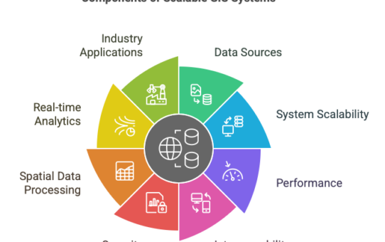
Scalable GIS System Architecture
By Shahabuddin Amerudin Introduction Geographic Information Systems (GIS) have undergone a profound transformation from static cartographic platforms to dynamic, high-throughput geospatial intelligenc... Read More
Theoretical Framework for AI and Predictive GIS in Pipeline Disaster Prevention
By Shahabuddin Amerudin The increasing frequency and severity of pipeline-related disasters, exemplified by the catastrophic 2025 Putra Heights gas explosion, highlight critical shortcomings in conven... Read More
Analisis Data Hilal Syawal 1446H / 2025M dan Penentuan Tarikh 1 Syawal di Malaysia
Pengenalan Penentuan awal bulan dalam kalendar Hijri, termasuk 1 Syawal, bergantung kepada kaedah rukyah (cerapan) dan hisab (pengiraan astronomi). Bagi Malaysia, kriteria Imkanur Rukyah dig... Read More
The Future of Geographic Information Systems
By Shahabuddin Amerudin Introduction Geographic Information Systems (GIS) have been a cornerstone of spatial analysis and decision-making for decades, fundamentally transforming how organizations unde... Read More
Analisis Data Radar dan Impak Hujan Lebat Berterusan dalam Kejadian Banjir di Johor pada 20 Mac 2025
Pada 19 dan 20 Mac 2025, Negeri Johor, khususnya Johor Bahru, mengalami hujan lebat berterusan yang mengakibatkan banjir besar. Analisis data radar cuaca dan parameter meteorologi memberikan gambaran ... Read More
Migrasi Data GIS: Transformasi dari Cassini dan RSO Lama ke Sistem GDM2000 dan WGS84
1. Keperluan Transformasi Sistem Koordinat GIS Sistem koordinat yang digunakan dalam pangkalan data GIS di Malaysia telah mengalami perubahan ketara dari era Cassini-Soldner (lama) dan RSO (lama)... Read More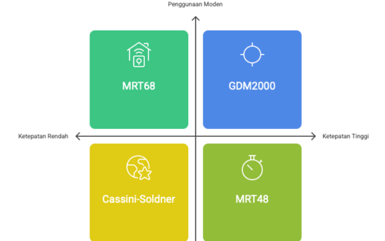
Sistem Koordinat di Malaysia Secara Ringkas
Oleh Shahabuddin Amerudin Pengenalan Sistem koordinat di Malaysia telah berkembang secara progresif dari zaman penjajahan hingga era moden. Perubahan ini mencerminkan keperluan untuk ketepatan geodeti... Read More
Understanding Geospatial and GIS
By Shahabuddin Amerudin Introduction Geospatial and Geographic Information Systems (GIS) are often used interchangeably, leading to misconceptions regarding their scope and application. While both c... Read More
Hari Juruukur Sedunia 2025: Transformasi Digital dan Peranan Juruukur dalam Pembangunan Mampan
Oleh Shahabuddin Amerudin Pengenalan Hari Juruukur Sedunia atau Global Surveyors’ Day disambut setiap tahun pada 21 Mac sebagai penghormatan kepada profesion juruukur yang memainkan perana... Read More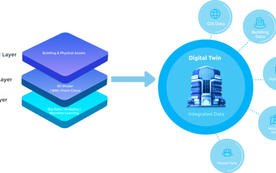
Advancing Digital Twins and GIS Integration
By Shahabuddin Amerudin In the 2021 article “Why Accenture lists ‘digital twins’ as top-five technology trend in 2021,” George Lawton (2021) explores the rising prominence of d... Read More
Singapore’s Country-Scale Digital Twin A Revolutionary Model for Smart Cities
By Shahabuddin Amerudin Introduction Singapore has been at the forefront of technological advancements in urban management and planning, with its ambitious initiative, Virtual Singapore. This project ... Read More
The Origins of Surveying in Malaysia: A Historical Overview
By Shahabuddin Amerudin Early Beginnings (1832-1880s) Establishment of State Survey Departments (1885 onwards) The need for accurate surveys to support land registration led to: Early Datums and Grid ... Read More
The Future of GIS and the Evolution of Emerging Concepts and Terminology
By Shahabuddin Amerudin Introduction For decades, Geographic Information Systems (GIS) have been the cornerstone of mapping, spatial analysis, and decision-making across a multitude of industries. Tra... Read More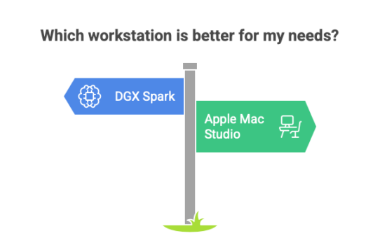
NVIDIA DGX Spark vs. Apple Mac Studio: Which AI Workstation Reigns Supreme?
By Shahabuddin Amerudin Introduction The NVIDIA DGX Spark is the latest innovation in AI computing, designed to bring supercomputer-level performance into a compact desktop-friendly form. Of... Read More
