


"Convey from me even if it is one verse" – Prophet Muhammad (PBUH)

This is an open source software for Open Conference that you can use to manage conference submission and reviewing by the referees.
website: https://pkp.sfu.ca/ocs/
download link: https://pkp.sfu.ca/ocs/ocs_download/
System Requirements
You will need, installed on your Web server:


Typically, all notebook batteries are built to handle a certain number of usage cycles, around 500, and often more. Each cycle of use decreases the battery’s capacity, so the less you drain it, the longer it’ll last.
If you leave your battery plugged in for long time it will cause heating issue. Letting a battery charge to 100 percent all the time does tend to wear the battery out more quickly, while letting it fall too lower in the other direction too often can also be bad news. The happy middle ground is, according to Battery University funder and Cadex Electronics CEO Isidor Buchmann, is somewhere between 40 percent and 80 percent battery life.
So the best thing you can do for your battery is charge when it reaches 40 percent, and unplug it when it goes past 80 percent.
Read more: http://www.digitaltrends.com/computing/how-to-care-for-your-laptops-battery/#ixzz3mzxbc073

According to metaefficient.com the best rechargeable AA batteries:
I’m using Eneloop by Panasonic (code BK-3MCCE) 1.2V 1900mAh. The price is RM41.00 for 2 batteries. You can use it for maximum 1500 times of recharging.
Attending the flood workshop at The Everly Hotel, Putrajaya.


Conceptually, in ABM you give instructions to virtual agents that allow the agents to interact. Agents can be animals, tanks, parcels, delivery trucks, or any discrete object. From the resulting decisions and actions of the agents, patterns are created in space and time. Unlike many other modeling techniques that quantify and then re-create the patterns, agent-based models explore the causes of the patterns; the patterns are emergent properties from the individual decisions of the agents.
Agent-based modeling, combined with spatial data, allows you to address a wide array of problems such as the following:
Many phenomena or agents exist and make decisions in, and relative to, space. The location of an agent and its surrounding environment will influence the agent’s decision making. The agent can influence or change the landscape it interacts with. A GIS is a spatial modeling tool that stores, displays, and analyzes data on spatial relationships. A natural synergy exists between ABM and a GIS. Agent Analyst is free, open-source software developed to integrate an ABM development platform—the Recursive Porous Agent Simulation Toolkit (Repast)—within a GIS (ArcGIS). Agent Analyst is a mid-level integration that takes advantage of both modeling environments.
Source: Agent Analyst – Agent-Based Modeling in ArcGIS by Kevin M. Johnston, Esri Press (2013)
By Shahabuddin Amerudin
A Valuable Tool for Geospatial Data Conversion
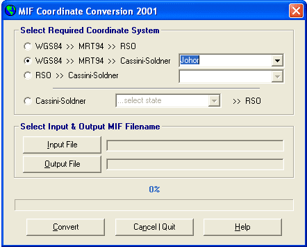
The MIF Coordinate Conversion 2001 tool has proven to be invaluable for geospatial professionals working with MapInfo data in MIF format. This application enables seamless conversion between various coordinate systems, including WGS84, RSO and State Cassini. The conversions are executed with exceptional precision, ensuring accurate and reliable results.
A History of Development and Use
Originally developed in Microsoft Visual Basic Version 6 in the late 1990s, this tool has undergone continuous improvements over the years to enhance its functionality and performance. Its significance was particularly evident during my academic pursuits at UTM, where it played a crucial role in my Final Year Project (PSM).
Application in Geospatial Research
My PSM project focused on the impact of using multi-data sources in GIS databases from different coordinate systems. Given the limitations of GPS technology at the time, including Selective Availability (SA), the collected GPS data required correction using Differential GPS (DGPS) techniques. The MIF Coordinate Conversion tool was instrumental in this process.
One of the key aspects of the project was evaluating the effectiveness of DGPS in a scenario where the GPS base station was located in Kuala Lumpur and the rover was in Johor Bahru. This study highlighted the challenges of real-time coordinate transformations in GIS software at that time. Many GIS packages struggled to perform accurate conversions due to incorrect parameter usage and unfamiliar transformation formulas.
Conclusion
The MIF Coordinate Conversion 2001 tool has been a valuable asset for geospatial professionals, especially during a time when real-time coordinate transformations were limited. Its ability to accurately convert between various coordinate systems has contributed significantly to the advancement of geospatial analysis and research.
Lecture note for 1st lecture MGHG1544 GIS Application Development

The first lecture and probably with a laboratory will be commenced on the Sunday, 6th September 2015 from 2.00 – 6 pm. Get ready!
When you are doing research you are primarily focused on your hypothesis, methods, test results and research outcome. You are an expert in your research field and are very aware of what others are researching and publishing too. But the actual art of getting your own paper ready for publication requires quite some expertise and a great deal of serious attention and preparation. Please join us for the online lecture:
https://www.publishingcampus.elsevier.com/pages/210/How-do-Editors-look-at-your-paper.html