Almost Free Platforms to Host A Web Map Application

For almost free platforms to host your web map application, there are several options available:

  1. GitHub Pages: GitHub Pages is a service provided by GitHub that allows you to host static websites for free. You can use it to host a simple web map application that only displays data and does not require a server-side processing.

  2. Firebase: Firebase is a platform provided by Google that allows you to build and host web applications for free. It includes a real-time database, authentication, and hosting services. It can be used to host a simple web map application that only displays data and does not require a server-side processing.

  3. Heroku: Heroku provides a free plan that allows you to host web applications with a limited number of resources. You can use it to host a simple web map application that only displays data and does not require a server-side processing.

  4. Netlify: Netlify is a platform that allows you to host web applications and static websites for free. You can use it to host a simple web map application that only displays data and does not require a server-side processing.

  5. OpenShift: OpenShift is a platform provided by Red Hat that allows you to host web applications for free. It provides a free plan that allows you to host web applications with a limited number of resources.

It’s worth noting that these platforms may have limitations and restrictions on the amount of traffic and storage space, and the free plans may not be sufficient for more complex or high-traffic applications. It’s always a good idea to consult the pricing plans of each platform and evaluate the best options for your specific needs.

As a researcher at a university with a limited budget, there are several options you can consider to host your web map application:

  1. Use a local server: You can set up a local server on your own computer or on a university server to host your web map application. This option is the most cost-effective, but it may have limitations on scalability and availability.

  2. Use a cloud-based platform with a free tier: Many cloud-based platforms such as AWS, Azure, and Google Cloud Platform offer free tiers that allow you to host your web map application for free or with minimal costs. These free tiers usually have limitations on resources and usage, but they are a good option for development and testing.

  3. Use a community-driven platform: There are also community-driven platforms such as OpenShift, OpenStack, and OpenFaaS that provide free or low-cost hosting for open-source projects. These platforms are usually community-supported and may have limitations on resources and support.

  4. Leverage open-source software: There are also a lot of open-source web mapping software such as GeoServer, MapServer, and QGIS Server that you can use to host your web map application. These software are free to use and are actively developed and maintained by the community.

  5. Look for grants or funding: You may also look for grants or funding opportunities through your university or other organizations to support the development and hosting of your web map application.

It’s always a good idea to evaluate the best options for your specific needs and budget, and consult with your university IT department.

Low-Cost Platforms to Host A Web Map Application

For a low-cost platform to host your web map application, there are several options available:

  1. AWS Elastic Beanstalk: This is a fully managed service from AWS that allows you to deploy and run web applications and services. It supports a variety of programming languages including Python and Node.js. It also provides monitoring, automatic scaling, and automated health reporting.

  2. Heroku: This is a cloud-based platform that allows you to deploy, run, and manage web applications. It supports a variety of programming languages including Python and Node.js. It also provides monitoring, automatic scaling, and automated health reporting.

  3. Google Cloud Platform (GCP): GCP provides a variety of services for web application hosting and deployment. It supports a variety of programming languages including Python and Node.js. It also provides monitoring, automatic scaling, and automated health reporting.

  4. DigitalOcean: DigitalOcean is a cloud-based platform that allows you to deploy, run, and manage web applications. It supports a variety of programming languages including Python and Node.js. It provides monitoring, automatic scaling, and automated health reporting.

  5. Azure App Service: Azure App Service is a fully managed platform for building and deploying web applications. It supports a variety of programming languages including Python and Node.js. It also provides monitoring, automatic scaling, and automated health reporting.

It’s important to note that these platforms have a free tier that can be used for development and testing, and the costs increase as the usage increases. It’s always a good idea to consult the pricing plans of each platform and evaluate the best options for your specific needs.

Developing A Web Map Application for Line Simplification using DP Algorithm

Developing a web map application for line simplification using the Douglas-Peucker algorithm requires a systematic approach, and the Systems Analysis and Design methodology can be used for this purpose. The following steps can be followed to develop the web map application:

  1. Requirements gathering: This step involves identifying the requirements for the web map application. This includes understanding the user needs, identifying the data sources and data requirements, and defining the functional and non-functional requirements for the application.

  2. Systems analysis: In this step, the requirements gathered in the previous step are analyzed to understand how the system will work. This includes analyzing the data flow, data relationships, and the overall architecture of the system.

  3. Design: In this step, the system is designed using the information gathered in the previous steps. This includes designing the user interface, the database schema, and the overall architecture of the system.

  4. Implementation: In this step, the system is implemented using the design created in the previous step. This includes developing the user interface, implementing the database, and integrating the various components of the system.

  5. Testing and Deployment: In this step, the system is tested to ensure that it meets the requirements and is free from bugs. Once it is confirmed that the system is working correctly, it can be deployed for use.

  6. Maintenance: In this step, the system is maintained to ensure that it continues to work correctly and to make any necessary updates or changes.

Using structured analysis techniques such as data flow diagrams, entity-relationship diagrams, and flowcharts can help you to effectively design the system and communicate the design to the development team.

Here is a possible high-level architecture for the application:

  1. User interface: The application should have a user-friendly interface that allows users to upload and download data, view the processed data, and see the status of their uploads.

  2. Data processing: The application should process the data using the Douglas-Peucker algorithm and return the processed data to the user.

  3. Data storage: The application should store the uploaded data in a temporary storage area and delete it after a certain period of time.

  4. Data validation: The application should validate the uploaded data to ensure that it is in the correct format and that it meets the size limit.

  5. Security: The application should have security measures in place to protect the data and ensure that only authorized users can access it.

  6. Scalability: The application should be scalable to handle a large number of users and a large amount of data.

  7. Monitoring: The application should have monitoring capabilities to track the performance and usage of the application.

  8. Error handling: The application should have error handling mechanisms in place to handle any errors that may occur during the processing or uploading of data.

It’s worth noting that this is a basic overview of the architecture and the specific implementation will require more detail and work, for example, the specific technology stack, security measures, hosting, and other considerations.

There are several programming languages and platforms that could be used to develop the application.

  1. For the front-end, JavaScript frameworks such as React, Angular, or Vue.js can be used to create a user-friendly interface and handle user interactions.

  2. For the back-end, a language such as Python or Node.js can be used to handle data processing, storage, and validation. Python has libraries such as Fiona and Shapely that can be used to handle shapefile data, and the Douglas-Peucker algorithm can be implemented using libraries such as Shapely or GEOS.

  3. For the database, a NoSQL database such as MongoDB or a SQL database such as PostgreSQL can be used to store the uploaded data.

  4. For hosting and deployment, platforms such as AWS, Azure, or Heroku can be used to host the application and provide scalability and monitoring capabilities.

  5. For security, it is recommended to use a framework such as Express or Flask for Node.js and Python respectively, to handle user authentication and authorization, data encryption, and other security measures.

It’s worth noting that this is just a suggestion, and the specific implementation will depend on the requirements and constraints of the project.


Creating An Application Visual Interface

There are several programming languages that can be used to create an application interface, and the choice of which one to use will depend on the specific requirements and constraints of your project. Some of the most popular languages for creating visual interfaces include:

  1. Python: Python is a popular and versatile language that has a wide range of libraries for creating visual interfaces. Some popular libraries for creating visual interfaces in Python include Tkinter, PyQt, and wxPython. These libraries provide a simple and easy-to-use API for creating graphical user interfaces (GUIs) and can be used to create desktop applications and web applications.

  2. C#: C# is a popular language for creating Windows desktop applications and has a built-in library called Windows Forms for creating graphical user interfaces. It also has the advantage of being able to use the Microsoft Visual Studio development environment, which provides a visual designer and a wide range of tools for creating and debugging applications.

  3. Java: Java is a popular language for creating cross-platform desktop applications and has a built-in library called Swing for creating graphical user interfaces. It also has the advantage of being able to use the Eclipse development environment, which provides a visual designer and a wide range of tools for creating and debugging applications.

  4. JavaScript: JavaScript is a popular language for creating web applications and has a wide range of libraries and frameworks for creating visual interfaces. Some popular libraries for creating visual interfaces in JavaScript include React, Angular, and Vue. These libraries provide a simple and easy-to-use API for creating web user interfaces and can be used to create web applications.

It’s important to note that these are just a few examples of the many languages that can be used to create visual user interfaces, and the choice of which one to use will depend on the specific requirements and constraints of your project.

Creating a application interface using Python, C#, Java, or JavaScript may have a slightly different syntax and approach compared to Visual Basic (VB) but it can be considered as easy, depending on your experience and familiarity with the language.

Python, C#, Java, and JavaScript all have built-in libraries or frameworks for creating visual interfaces, which provide a simple and easy-to-use API for creating graphical user interfaces (GUIs) similar to Visual Basic.

For example, Tkinter in python, Windows Form in C#, Swing in Java, React, Angular and Vue in JavaScript, all provide a visual designer and a wide range of tools for creating and debugging applications, similar to the experience of using Visual Basic.

It’s worth noting that VB is a simple and easy-to-use language that is well suited for creating graphical user interfaces, and it has a built-in library called Windows Forms for creating visual interfaces.

However, the choice of language and library depends on the specific requirements and constraints of your project. If you are more familiar with one of these languages, it will probably be easier for you to create a visual interface using that language.

How to Detect User in A Web Application

There are several ways to detect the user in a web application, it depends on the requirements and the architecture of your application. Here are a few examples:

  1. Cookies: Cookies are small text files stored on the client’s browser. You can use them to store a unique identifier for the user, such as a user ID or session ID. When the user makes a request to your server, you can read the cookie and use the identifier to look up the user in your database.

  2. JWT (Json Web Token) : JWT is a compact and self-contained way for securely transmitting information between parties. JWT can be used to identify the user, you can store user information inside the JWT and attach it to the client’s browser. When the client makes a request, it will send the JWT with the request and the server can decode the JWT to get the user information.

  3. IP Address: The IP address is a unique numerical label assigned to each device connected to a computer network that uses the Internet Protocol for communication. You can use the IP address to identify the user, however, it has some limitations as IP addresses can change and be shared among multiple users.

  4. Fingerprinting: Fingerprinting is a technique that uses various browser and device attributes to create a unique identifier for the user. These attributes can include browser type, screen resolution, installed fonts, and more. Fingerprinting can be used to identify the user, but it has limitations as some attributes can be easily spoofed.

  5. Mobile Device ID: If you are developing a mobile app, you can use the unique device ID provided by the operating system to identify the user.

It’s important to keep in mind that all of these options have their own advantages and limitations, you should consider the security, privacy, and scalability aspects when choosing the way to detect the user.

Creating A Web Application with Python

Steps for creating a web application with Python for both the front-end and back-end: 

  1. Create a virtual environment: It’s a good practice to create a separate virtual environment for your project. This allows you to manage dependencies and keep your system organized. You can use tools like virtualenv or conda to create a virtual environment.

  2. Install the necessary libraries: You’ll need to install libraries for the web framework, forms handling, and file processing. For example, you can use Flask for the web framework, Flask-WTF for forms handling, and Fiona for file processing. You can install these libraries using pip.

  3. Create a Flask app: Create a file app.py and import Flask and other necessary libraries. Create a Flask app and define routes for handling the requests.

  4. Create forms: Use Flask-WTF or WTForms to create forms for handling user input. You can create forms for file upload, user registration, and other functions.

  5. Handle file processing: Use Fiona to handle the shapefile processing, and the douglas-peucker package to perform the line simplification.

  6. Handle user authentication: Implement user authentication using cookies or sessions.

  7. Create template files: Create template files using Pyjade or another templating engine to define the structure of the web pages.

  8. Run the app: Run the app using flask run in the command line. The app will be available at http://localhost:5000/ by default.

Keep in mind that this is a high-level overview of the process. There are many details and considerations to take into account when building a web application. 

Saving GIS Data to Another File Format using Python

Once you have read the data from a GIS file using Fiona, you can save it to another file format using the fiona.open() method and the ‘w’ mode. You can also use the fiona.open() method to save the data to a new file, by specifying the file path and format, and passing the ‘w’ mode as the second argument.

Here is an example of how to save the data from a shapefile to a geojson file:

In this example, the data is read from a shapefile and written to a geojson file. The properties, crs, and schema of the new file are defined from the source file using the src.schema and src.crs attributes.

It’s important to note that when saving the data to a new file, the file format and the driver must be specified correctly, and the schema and properties must match the data being written. You can also use the same approach to save the data to other file formats such as KML, CSV, or any other format supported by Fiona. You just need to change the driver and the file path and extension accordingly.

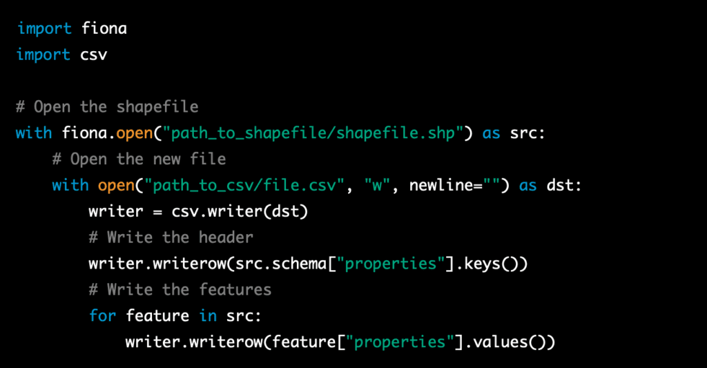
For example, to save the data to a CSV file:

This example uses the built-in csv library to write the data to a CSV file. It writes the header of the file using the keys of the properties from the source file and then it writes the values of the properties for each feature.

It’s worth noting that this is a basic example that can be extended and customized to suit the specific requirements of your project, and it’s recommended to consult the documentation of Fiona for more detailed information on how to use it and to have a deeper understanding of the functionality it offers.

Additionally, it’s important to thoroughly test your code and ensure that the data is being written correctly before deploying it.

How to Read Several Common GIS Data Types using Python

If you need to read several common GIS data types, such as shapefiles, geojson, KML, and others, in addition to the OGR library, you can use Fiona library. Fiona is a python library for reading and writing spatial data files. It is built on top of OGR and is designed to be more user-friendly and pythonic.

Fiona provides a simple, pythonic API to read and write spatial data files. It allows you to read and write data in several formats such as shapefiles, geojson, kml, and others. It is easy to use, you can open a file using Fiona and access the data just like a Python dictionary.

Here is an example of how to read a shapefile using Fiona:

This example shows how easy it is to read a shapefile using Fiona, you can open a file, iterate over the features and access the data, and close the file using the “with” statement.

Fiona also supports other formats such as geojson, KML, and others, you can use the same approach to read these other formats, by simply changing the file path and extension when opening the file with the fiona.open() method. For example, to read a geojson file, you would use:

Fiona also allows you to specify the driver when opening a file, in case the file format is not recognized by the library, this can be done by passing the driver name as a second argument to the fiona.open() method.

For example, to open a KML file, you would use:

Fiona also allows you to access the metadata of the file, such as the crs, schema, and properties, in a similar way as the features, it also allows you to write data to a file, in the same way you read it, you can simply iterate over the features and write them to a file.

It’s worth noting that fiona, as well as OGR, are powerful libraries that can handle a wide range of GIS data types and formats, it’s recommended to consult the Fiona documentation for more detailed information on how to use it and to have a deeper understanding of the functionality it offers.

How to Read Features and Coordinates from ESRI Shapefile using Python

Here is an example of how to read in features and coordinates from an ESRI Shapefile using Python in a script using the OGR library:

In this example, the code will open the shapefile, read in the features and coordinates, and then output the coordinates to the console. You can replace this step with your own code to do something with the features and coordinates, such as displaying them on a map or storing them in a database.

In order to read in features and coordinates from an ESRI Shapefile using Python, you will need to import the OGR library. The OGR library is part of the GDAL library, which is a powerful library for working with GIS data. The OGR library is used to read and write vector data, it supports a variety of vector formats including ESRI Shapefile. 

In the example I provided before, the library is imported at the beginning of the script using the following line of code:

This line imports the OGR library, allowing you to use its functions and methods to read in features and coordinates from the shapefile.

It’s important to note that you may need to install GDAL library to use the OGR library, you can install it via pip by running pip install gdal in your command prompt or terminal.

How to Read Features and Coordinates from ESRI Shapefile using VB.net

Reading features and coordinates from an ESRI Shapefile in Microsoft Visual Studio can be done by creating a new project and adding the necessary references to the OGR library. Here are the general steps to follow:

  1. Create a new project in Microsoft Visual Studio. This can be a Console Application, Windows Forms Application, or any other type of project that suits your needs.

  2. Add a reference to the OGR library. This can be done by right-clicking on the project in the Solution Explorer and selecting “Add Reference.” Then, browse to the location where the OGR library is installed and select the appropriate DLLs to add as references.

  3. Use the code shown below to read in the features and coordinates from the shapefile. You will need to update the path of the shapefile to the actual path on your local machine or server.

  4. Add any additional code to display the features and coordinates on a map or store them in a database. This can be done by using other libraries such as MapWinGIS or SharpMap for displaying on a map or ADO.NET for storing in a database.

  5. Build and run the project to test the code and ensure that it is working correctly.

It’s worth noting that this is just a general overview of the steps involved in implementing the reading of features and coordinates from an ESRI Shapefile in Microsoft Visual Studio, and the actual implementation will depend on the specific requirements and constraints of the project. Additionally, you may need to install the GDAL library to be able to use the OGR library on your machine.

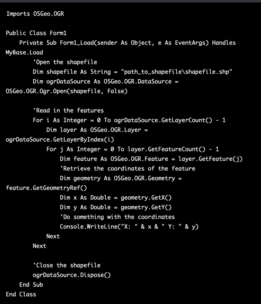
Here is an example of how to read in features and coordinates from an ESRI Shapefile using VB.net in a Windows Forms application in Microsoft Visual Studio:

In this example, the code is placed in the Load event of the form, which will be executed when the form is loaded. You can also place this code in a button click event or any other event that suits your needs. It’s important to note that you will need to update the path of the shapefile to the actual path on your local machine or server. Also, you may need to add a reference to the OGR library, you can do this by right-clicking on the project in the Solution Explorer and selecting “Add Reference.” Then, browse to the location where the OGR library is installed and select the appropriate DLLs to add as references.

Additionally, as with any software development project, it’s important to thoroughly test your code and ensure it’s working correctly before deploying it. You can also add additional code to display the features and coordinates on a map or store them in a database, this can be done by using other libraries such as MapWinGIS or SharpMap for displaying on a map or ADO.NET for storing in a database. It’s also important to consider how you want to present the data to the user, you can use the data you get from the shapefile to create a map, a table, or any other type of visualization that fits your needs.

It’s worth noting that this is a basic example that can be extended and customized to suit the specific requirements of your project, and it’s recommended to consult the documentation of the OGR library and other related libraries to have a deeper understanding of the functionality they offer and how to use them correctly.

Creating A “geopostcode” System

Creating a “geopostcode” system, also known as a “plus code” system, involves assigning unique codes to individual streets, buildings, or even specific units within a building. The process of creating such a system can be complex and would involve several steps. Below is an example of the pseudocode for creating a “geopostcode” system:

  1. Start by gathering data on all addresses and locations in the area to be covered by the “geopostcode” system. This data should include information on street names, building numbers, and other relevant details.

  2. Use this data to create a digital map of the area, with each address and location represented by a unique point on the map.

  3. Divide the area into smaller sections, such as neighborhoods or blocks. Assign a unique code to each section, based on its location on the map.

  4. Within each section, assign a unique code to each street, building, or unit. This can be done by using a combination of the section code and a unique identifier for the street, building, or unit.

  5. Test the “geopostcode” system by using it to locate specific addresses and ensure that the codes are accurately identifying the correct locations.

  6. Implement the “geopostcode” system, and update it as necessary to reflect any changes in the area.

It’s worth noting that this is just an example of the pseudocode, and the actual implementation of a “geopostcode” system would involve more complexity, additional steps and a high level of accuracy to ensure the codes are accurate and reliable.

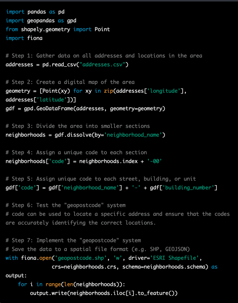
Converting the pseudocode for creating a “geopostcode” system into actual code would depend on the programming language and tools being used. Below is an example of how the pseudocode could be implemented in Python, using the Pandas and Geopandas library for data manipulation, and Fiona for reading/writing spatial data:

This is just an example of how the pseudocode for creating a “geopostcode” system could be implemented in Python. The actual implementation would depend on the specific requirements and constraints of the project, and would likely involve additional steps and a high level of accuracy to ensure that the codes are accurate and reliable.

It’s important to note that creating a “geopostcode” system is a complex task and it should be done by experts in GIS and data management. Additionally, it’s important to consider the legal aspects and regulations of the country where the system will be implemented.

Postcodes in Malaysia

In Malaysia, postal codes are known as “poskod” and are made up of five digits. The first two digits of a poskod indicate the state or federal territory in which the address is located. For example, a poskod beginning with “01” would indicate the state of Perlis, while a poskod beginning with “02” would indicate the state of Kedah. The next two digits of the poskod indicate a specific area within the state or federal territory, while the final digit is used as a check digit to ensure the accuracy of the poskod.

An example of a poskod in Malaysia would be “43000” which is the poskod of Kajang, Selangor. This poskod is composed of the first two digits “43” which indicates that it is located in Selangor state, the next two digits “00” which is not specific enough to identify the exact location within Selangor, and the last digit is used as a check digit.

It’s worth noting that postcode system in Malaysia is not as detailed as in other countries, it’s not able to identify the street or the house, but it can identify the general area or town.

Postcodes in Malaysia are used primarily for mail delivery and addressing purposes. Poskod are assigned to specific areas by the Malaysia Postal Services Department, and are used to ensure that mail is delivered to the correct location.

Poskod can also be used to identify areas for other purposes, such as emergency services, delivery of goods and services, and statistical analysis. For example, when you are filling out a form online, you may be asked to provide your poskod, which can be used to determine your location and provide you with relevant information or services.

In addition, many online map services, GPS systems, and other location-based applications in Malaysia use poskod as a means of identifying and locating specific addresses. They enable users to search for addresses and points of interest using poskod, making it easier to find the desired location.

It’s worth noting that the poskod system in Malaysia is not as detailed as in other countries, it’s not able to identify the street or the house, but it can identify the general area or town.

Creating a more detailed “geopostcode” system in Malaysia would involve assigning unique codes to individual streets, buildings, or even specific units within a building. This would require a significant investment in terms of time and resources, as well as a thorough update of the addressing system in Malaysia.

However, it is worth noting that a more detailed “geopostcode” system would have many benefits, such as improving the accuracy and efficiency of mail delivery, emergency services, and other location-based services. It would also make it easier for businesses and individuals to locate specific addresses, and would be useful for statistical analysis and planning purposes.

It is possible that the Malaysia Postal Services Department or other government agencies may consider implementing a more detailed “geopostcode” system in the future, but it’s hard to predict with certainty.

Postcode NG72RD

A postal code, also known as a zip code or postcode, is a series of letters and/or numbers that are used to identify a specific geographic location for the purpose of mail delivery. In the United Kingdom, postal codes are known as postcodes, and are divided into several parts, each with its own specific meaning.

The first two characters of a UK postcode, such as “NG” in the example of “NG72RD,” are called the “outward code.” These characters indicate the broader area or postal district in which the address is located. The outward code is used to sort mail at the main sorting office, and to help ensure that it is sent to the correct area for final delivery.

The next two characters, such as “72” in the example, are called the “inward code.” The inward code further refines the location of the address within the postal district, and helps to identify a specific street, group of streets, or group of properties.

The last two characters, such as “RD” in the example, are called the “sector code.” The sector code further refines the location of the address, and helps to identify a specific group of properties or a smaller area within the postal district.

Together, the outward code, inward code, and sector code form the full postcode, which can be used to accurately identify the location of a specific address for the purpose of mail delivery.

NG7 2RD is a non-residential postcode in Nottingham University (Main Site), Nottingham. It was first introduced in January 1980.

Coordinates

  1. Latitude: 52.9405 / 52°56’25″N
  2. Longitude: -1.1912 / 1°11’28″W
  3. OS Eastings: 454452
  4. OS Northings: 338429
  5. OS Grid: SK544384

Location Encoding

  1. Mapcode National: GBR LDV.41
  2. Mapcode Global: WHDGY.NCZ2
  3. Plus Code: 9C4WWRR5+6G
  4. Maidenhead Locator System: IO92jw75

What Three Birds: pintail.swift.skylark

Some part of this article sourced: https://checkmypostcode.uk/ng72rd#.Y8zc4y8Rpf0


Procedures to Create Geopostcodes

Creating a geocode or geopostcode involves several steps, including:

  1. Collecting location data: The first step in creating a geocode is to collect location data, such as addresses, postal codes, or place names. This data can be collected from a variety of sources, such as government databases, online directories, or GPS devices.

  2. Standardizing and cleaning the data: The collected data must be cleaned and standardized to ensure that it is accurate and consistent. This may involve correcting errors in the data, such as misspellings, and formatting the data in a consistent way.

  3. Matching the data to geographic coordinates: Once the data is cleaned and standardized, it must be matched to its corresponding geographic coordinates, such as latitude and longitude. This process is known as geocoding, and it can be done using a variety of methods, such as using a web-based geocoding service, or by using a software tool or programming library.

  4. Storing and updating the data: The geocoded data must be stored in a database or other data repository, and it should be updated regularly to ensure that it remains accurate.

  5. Making the data available: The geocoded data can be made available to users through a variety of means, such as through a web-based mapping application, an API, or a data download.

It’s worth noting that, creating a geocode or geopostcode can be a complex process and it requires a significant investment in time, resources, and expertise. Additionally, the quality and accuracy of the geocoding results can vary depending on the data sources and algorithms used.

Applications of Geopostcode in the United Kingdom

Here are a few examples of real-world applications where geocoding with postcodes is used in the United Kingdom:

  1. Mapping and navigation: The UK’s Ordnance Survey provides a mapping service called OS Maps, which allows users to view and print maps of the UK using postcodes. This service is used by hikers, cyclists, and other outdoor enthusiasts to plan routes and to find locations.

  2. Retail and marketing: Royal Mail’s postcode data is used by businesses to identify areas with high concentrations of potential customers and to target their marketing campaigns. For example, a car dealership might use postcode data to identify areas with a high density of households with high incomes, and target its advertising for luxury cars to those areas.

  3. Logistics and delivery: Royal Mail’s postcode data is used by companies such as DHL and UPS to sort and deliver mail and packages. They use postcodes to identify the location of an address and to optimize the routes of their delivery vehicles.

  4. Public services: The UK’s National Health Service (NHS) uses geocoding with postcodes to plan and deliver healthcare services. For example, it uses postcode data to identify areas with high concentrations of elderly people and to plan services such as geriatric care.

  5. Real estate and property management: Real estate professionals and property managers use geocoding with postcodes to identify and map properties, as well as to determine the value of a property. They might use postcode data to identify properties that are in high-demand areas or that are at risk of flooding or other hazards.

  6. Public transport: Transport for London (TFL) uses geocoding with postcodes to plan and operate public transport services, such as bus and rail. They use postcodes to identify the location of stops, stations, and depots, and to optimize routes and schedules.

These are just a few examples of how geocoding with postcodes is being used in the UK to improve decision-making and operational efficiency in various fields and industries.

Geocoding in The United Kingdom

In the United Kingdom, geocoding is commonly referred to as “geopostcode” and is used for a variety of applications, such as mapping, marketing, and logistics.

The Royal Mail, which is the UK’s postal service, assigns a unique postal code, known as a “postcode” to every address in the country. These postcodes are used by the Royal Mail to sort and deliver mail, but they are also widely used in other applications as a way of identifying and locating specific addresses.

The Royal Mail provides a Postcode Address File (PAF) that contains the postcode and location data for every address in the UK. This data can be used for geocoding, and it is widely used by businesses, government agencies, and other organizations to match addresses to their corresponding geographic coordinates.

The Royal Mail also provides an online geocoding service, known as “Code-Point Open,” that allows users to match postcodes to their corresponding geographic coordinates. This service is free to use, and it is widely used by businesses, researchers, and developers to geocode addresses and locations in the UK.

The Ordnance Survey, which is the UK’s national mapping agency, also provides a geocoding service, known as “Code-Point with Polygons,” that includes additional data such as the boundaries of administrative areas, such as local government districts, and the shape of postcode areas.

Overall, the use of postcodes as a form of geocoding is widely used and accepted in the UK, and it provides a consistent and accurate way of identifying and locating addresses in the country. The Royal Mail’s PAF and online geocoding services are widely used, and they provide a valuable resource for businesses, government agencies, and other organizations that need to geocode addresses and locations in the UK.

Here are a few examples of how geocoding with postcodes is used in the United Kingdom:

  1. Delivery and logistics: Companies such as Royal Mail, DHL, and UPS use geocoding with postcodes to sort and deliver mail and packages. They use postcodes to identify the location of an address and to optimize the routes of their delivery vehicles.

  2. Retail and marketing: Retailers such as Tesco and Sainsbury’s use geocoding with postcodes to identify areas with high concentrations of potential customers and to target their marketing campaigns. For example, they might use postcode data to identify areas with a high density of families with children, and target their advertising for baby products to those areas.

  3. Public services: Local government and emergency services use geocoding with postcodes to identify and respond to incidents more quickly and efficiently. For example, the police and fire department use postcodes to locate and respond to emergencies, and local government uses postcodes to plan and deliver public services.

  4. Real estate and property management: Real estate professionals and property managers use geocoding with postcodes to identify and map properties, as well as to determine the value of a property. They might use postcode data to identify properties that are in high-demand areas or that are at risk of flooding or other hazards.

  5. Public health: Public health professionals use geocoding with postcodes to map and track the spread of infectious diseases and to identify areas with high concentrations of health risks such as air pollution and poor access to healthcare.

  6. Transportation: Transportation companies use geocoding with postcodes to optimize routes, reduce transportation costs, and improve delivery times.

These are just a few examples of how geocoding with postcodes is used in the United Kingdom. Postcodes provide a consistent and accurate way of identifying and locating addresses in the country, and they are widely used in various applications to improve decision-making and operational efficiency.

Successful Implementations of Geocoding

there are many successful implementations of geocoding in various applications. Here are a few examples:

  1. Google Maps: Google Maps is one of the most widely used geocoding applications, providing users with turn-by-turn navigation, real-time traffic information, and detailed street-level maps. The application uses geocoding to match addresses and points of interest to their corresponding geographic coordinates, and it also allows users to search for locations and plan routes.

  2. Uber and Lyft: Uber and Lyft are ride-hailing services that use geocoding to match riders with drivers and to calculate the estimated time of arrival and fare. The applications use geocoding to determine the location of riders and drivers, and to route the driver to the rider’s pick-up location.

  3. ArcGIS: ArcGIS is a geographic information system (GIS) software used by organizations to create, manage, and analyze spatial data. The software includes a geocoding tool that allows users to match addresses and other location-based data to their corresponding geographic coordinates, and it also provides tools for visualizing, analyzing and managing the data.

  4. Facebook: Facebook uses geocoding to enable users to tag their location in posts and photos, and to search for nearby places and businesses. The application uses geocoding to match the location data from users’ devices to the corresponding geographic coordinates, and it also allows users to search for locations and plan routes.

  5. National Flood Insurance Program (NFIP): The National Flood Insurance Program (NFIP) uses geocoding to map areas that are at risk of flooding, and to determine the cost of flood insurance premiums. The program uses geocoding to match properties to their corresponding geographic coordinates, and it also uses data from GIS and remote sensing to identify and map areas that are at risk of flooding.

These are just a few examples of the many successful implementations of geocoding in various applications. Geocoding is a widely used and powerful tool that can help to improve

Geocode, Geopostcode or Geocoding

A geocode, also known as a “geopostcode” or “geocoding” is a set of geographic coordinates, such as latitude and longitude, that corresponds to a specific location, such as a street address, city, or postal code. Geocoding is the process of converting a location description, such as an address or postal code, into a set of geographic coordinates that can be plotted on a map.

Geocoding is used in a variety of applications, such as mapping, transportation, and marketing. For example, geocoding can be used to display locations on a map, to determine the closest locations to a given point, to plan routes, and to target advertising to specific geographic areas.

There are several ways to geocode an address or postal code, such as using a web-based geocoding service, or by using a software tool or programming library. Some of the popular geocoding services are Google Maps, OpenStreetMap, Mapbox, ArcGIS, etc.

Geocoding services use a variety of data sources, such as street address databases, satellite imagery, and geographic information systems (GIS) data, to match an address or postal code to its corresponding geographic coordinates. The quality and accuracy of the geocoding results can vary depending on the data sources and algorithms used.

It’s important to note that geocoding can be a complex process and some addresses or postal codes may be difficult to geocode, such as rural or remote areas, or areas that have recently been developed. Additionally, errors or inaccuracies in the input data, such as misspellings, can also affect the geocoding results.

Overall, geocoding is a powerful tool for understanding and visualizing location-based data, and it can be used in a wide range of applications. However, it’s important to understand the limitations and potential inaccuracies of the process, especially when using it for important decisions.

Some examples of how geocoding is used in different applications include:

  1. Mapping and navigation: Geocoding is used to display locations on a map, such as points of interest, real estate listings, and weather forecasts. It can also be used to determine the closest locations to a given point and to plan routes. For example, ride-sharing apps like Uber and Lyft use geocoding to match riders with drivers, and to calculate the estimated time of arrival and fare.

  2. Retail and marketing: Geocoding is used to target advertising to specific geographic areas. Retailers and businesses can use geocoding to identify areas with high concentrations of potential customers, and to optimize their marketing campaigns. For example, a fast-food chain could use geocoding to identify areas with a high density of office buildings, and target its lunchtime advertising to those areas.

  3. Emergency services and logistics: Geocoding is used by emergency services, such as the police and fire department, to locate and respond to incidents more quickly and efficiently. Logistics companies use geocoding to optimize routes and reduce transportation costs.

  4. Public safety and security: Geocoding is used by government agencies to identify and respond to natural disasters, such as floods and hurricanes. It can also be used to identify and respond to security threats, such as crime hotspots and terrorist attacks.

  5. Urban planning and urban design: Geocoding is used by urban planners and urban designers to understand and visualize the relationships between different land uses, population density, and transportation patterns in a city. They use geocoding to analyze and map data such as population demographics, land use patterns, and transportation infrastructure, to inform the planning and design of new developments, transportation systems, and public spaces. This helps them to make informed decisions about where to locate new housing, commercial developments, and public facilities, and how to improve transportation and accessibility.

  1. Environmental monitoring and management: Geocoding is used by environmental scientists and managers to monitor and manage natural resources such as water, air, and biodiversity. For example, geocoding can be used to map and track the spread of invasive species, to monitor water quality and air pollution, and to identify and map wetlands, forests, and other ecosystems that are at risk of degradation.

  2. Real estate and property management: Geocoding is used by real estate professionals and property managers to identify and map properties, as well as to determine the value of a property. It can also be used to identify properties that are at risk of flooding, landslides, or other hazards.

  3. Public health: Geocoding is used by public health professionals to map and track the spread of infectious diseases, as well as to identify areas with high concentrations of health risks such as air pollution and poor access to healthcare.

These are just a few examples of how geocoding is used in different applications. It’s a powerful tool that can be used in a wide range of fields and industries, and it can help to improve decision-making and operational efficiency by providing a better understanding of geographic patterns and relationships.

Sea Level Rise, Another Actions

Relocating people and communities to higher ground is one potential adaptation strategy for dealing with sea level rise. However, it is important to consider that this approach is not always practical or feasible, and it can come with many challenges.

Relocating entire communities can be very difficult and expensive, as it requires acquiring land, building new infrastructure, and providing housing and other services for residents. It can also be emotionally and socially disruptive, as people may be separated from their families, friends, and cultural heritage. Additionally, in many areas, there may not be suitable land available at higher elevations to which people can be moved.

Another important factor to consider is the impacts on the ecosystem and biodiversity of the area, as sea-level rise may submerge coastal ecosystems, but relocating people to higher land could lead to destruction of other ecosystems and displacement of other species.

Instead, a more feasible approach would be to implement a combination of adaptation measures, such as building sea walls, elevating buildings, and improving drainage systems, to reduce the risk of flooding and erosion in vulnerable coastal areas. This approach allows people to stay in their homes and communities, while also reducing the risk of flooding.

However, in some cases, relocating to higher land might be the best option, especially for small islands or areas where the sea level rise is very high and other adaptation measures are not possible. In these cases, the decision should be made based on the specific circumstances, and with the participation and consent of affected communities.

It’s worth noting that the best approach will vary depending on the specific location, and a thorough assessment of the options and their impacts should be conducted before making a decision.

There is no one-size-fits-all answer to what is considered a safe minimum level of sea level rise, as it can vary depending on the location, the specific vulnerabilities and risks, and the availability and cost of adaptation measures. However, in general, the safe minimum level of sea level rise would be the level at which the impacts of sea level rise can be effectively managed through a combination of adaptation measures such as building sea walls, elevating buildings, and improving drainage systems.

The Intergovernmental Panel on Climate Change (IPCC) suggests that sea level rise should be limited to less than 1.5 meters (about 5 feet) by the end of the century in order to avoid the worst impacts of sea level rise on coastal communities and ecosystems. However, it’s worth noting that this is an ambitious target and it will be difficult to achieve if greenhouse gas emissions are not significantly reduced.

It’s also important to note that even small amounts of sea level rise can have significant impacts, especially in low-lying areas, so it’s important to take action to reduce the risk of flooding and erosion even at relatively low levels of sea level rise.

It’s also worth noting that, as sea level rise is a slow-moving process, the effects are cumulative, so even small amounts of sea level rise over time can cause significant damage. It’s important to take action to reduce the risk of flooding and erosion, as well as to plan for the long-term impacts of sea level rise.

In summary, the safe minimum level of sea level rise would be the level at which the impacts of sea level rise can be effectively managed through a combination of adaptation measures, and it’s important to take action to reduce the risk of flooding and erosion even at relatively low levels of sea level rise.

Sea Level Rise Actions

To address the challenges posed by sea level rise, there are a number of actions that can be taken at the individual, community, and government level:

  1. Reduce greenhouse gas emissions: The main driver of sea level rise is the warming of the Earth’s atmosphere caused by the increase of greenhouse gases such as carbon dioxide in the atmosphere. Reducing emissions from power generation, transportation, and industry can help to slow the rate of sea level rise.

  2. Implement adaptation measures: Building sea walls, relocating critical infrastructure, and elevating buildings can help to reduce the impacts of sea level rise on coastal communities. Additionally, zoning and building codes can be updated to discourage development in flood-prone areas.

  3. Improve monitoring and early warning systems: By improving monitoring and early warning systems, it will be possible to predict and respond to sea level rise and coastal flooding in a timely manner.

  4. Promote sustainable development in coastal areas: Encouraging sustainable development in coastal areas can help to reduce the risk of flooding and other impacts of sea level rise, while also preserving the natural resources and ecosystems that are important for the livelihoods and well-being of coastal communities.

  5. Conservation and restoration of coastal ecosystems: Coastal ecosystems such as wetlands, mangroves, and coral reefs can provide important protections for coastal areas against sea level rise and storm surges. Their conservation and restoration can help to mitigate the impacts of sea level rise.

  6. Community education and participation: Raising awareness and educating people about the risks and opportunities associated with sea level rise can help to build more resilient coastal communities. Encouraging community participation in sea level rise adaptation planning can also help to ensure that the needs and perspectives of local residents are taken into account.

  7. International cooperation: As sea level rise is a global issue, international cooperation is needed to effectively address it. Joining international agreements such as the United Nations Framework Convention on Climate Change (UNFCCC) and participating in international research programs can help to share knowledge, technology and resources to address the problem.

Overall, addressing sea level rise requires a multifaceted and coordinated approach, involving the participation of individuals, communities, government agencies, NGOs, and the private sector.