Apabila anda mendapat satu tugasan maka…
Apabila anda mendapat satu tugasan maka… Read More »
Typically, all notebook batteries are built to handle a certain number of usage cycles, around 500, and often more. Each cycle of use decreases the battery’s capacity, so the less you drain it, the longer it’ll last. If you leave your battery plugged in for long time it will cause heating issue. Letting a battery charge to 100 percent all the time does tend to wear the battery out more quickly, while letting it fall too lower in the other direction too often can also be bad news. The happy middle ground is, according to Battery University funder and Cadex Electronics
Taking care notebook’s battery Read More »
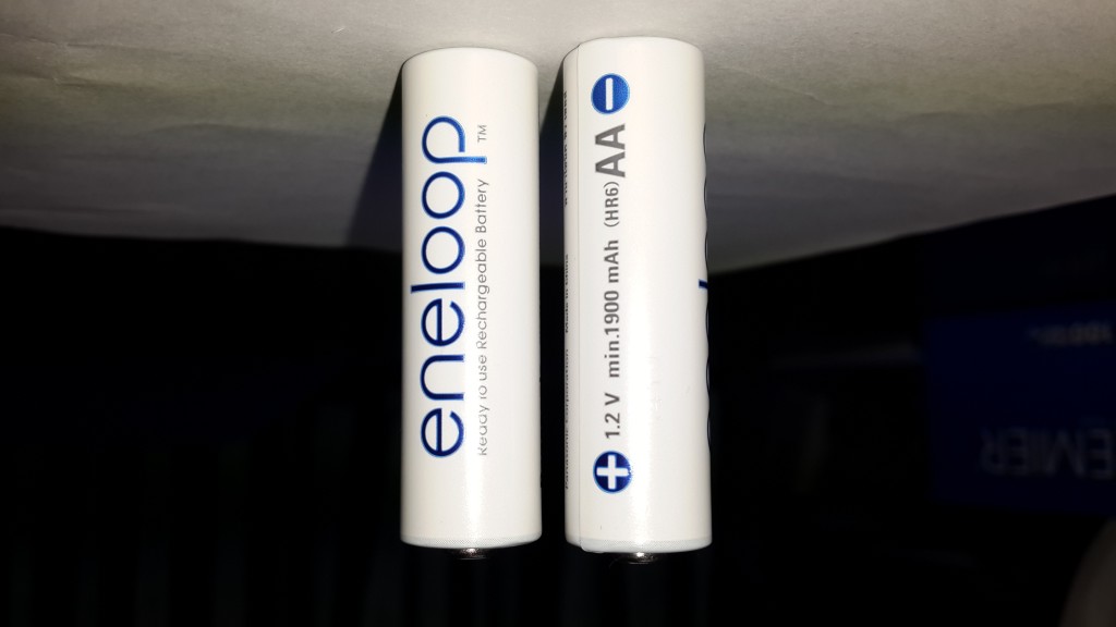
According to metaefficient.com the best rechargeable AA batteries: The best energy capacity (2550 mAh) — get the Eneloop Pro The maximum recharge capacity (2100 times) — get the 4th Generation Panasonic Eneloops To save some money and don’t mind a little less performance from your batteries — get the Imedion by Maha I’m using Eneloop by Panasonic (code BK-3MCCE) 1.2V 1900mAh. The price is RM41.00 for 2 batteries. You can use it for maximum 1500 times of recharging.
The best rechargeable battery size AA Read More »
Attending the flood workshop at The Everly Hotel, Putrajaya.
Kajian Bencana Banjir 2014 Read More »
SGHG3583 MGHG1544 Lecture #2 SGHG3583 MGHG1544 Lab #1 SGHG3583 MGHG1544 Lab #1 – extra
MGHG1544 Lecture #2 & Lab #1 Read More »
Officially Esri does not support ArcGIS software installed on a Mac. However, once a non- virtualized or virtualized environment is set up, Esri can support it. Just in case you want to run ArcGIS software with an Apple Mac. Follow this instruction: http://maps.uky.edu/support/docs/BP_ArcGIS_on_Macv5.pdf
Using ArcGIS software with an Apple Mac Read More »
Conceptually, in ABM you give instructions to virtual agents that allow the agents to interact. Agents can be animals, tanks, parcels, delivery trucks, or any discrete object. From the resulting decisions and actions of the agents, patterns are created in space and time. Unlike many other modeling techniques that quantify and then re-create the patterns, agent-based models explore the causes of the patterns; the patterns are emergent properties from the individual decisions of the agents. Agent-based modeling, combined with spatial data, allows you to address a wide array of problems such as the following: Developing corridor connectivity networks for wildlife movement
Agent-Based Modeling (ABM) Read More »
This application serves as a powerful tool for the seamless conversion of MapInfo data in MIF format across various coordinate systems, including transformations such as WGS84 to RSO, WGS84 to State Cassini, RSO to State Cassini, and State Cassini to RSO. The conversions are performed with a high level of precision, meeting stringent accuracy standards. Initially developed using Microsoft Visual Basic Version 6 in the late 1999, this utility has undergone continuous refinement over time to enhance its performance and capabilities. During my tenure as a student at UTM, this utility played a pivotal role in my Final Year Project
Malaysia MIF Format Coordinate Conversion Utility Read More »
Lecture note for 1st lecture MGHG1544 GIS Application Development SGHG3583 MGHG1544 Lecture #1
MGHG1544 Lecture #1 Read More »
The first lecture and probably with a laboratory will be commenced on the Sunday, 6th September 2015 from 2.00 – 6 pm. Get ready!
Announcement – SGHG3583 GIS Software Systems Read More »
When you are doing research you are primarily focused on your hypothesis, methods, test results and research outcome. You are an expert in your research field and are very aware of what others are researching and publishing too. But the actual art of getting your own paper ready for publication requires quite some expertise and a great deal of serious attention and preparation. Please join us for the online lecture: Presentation: Valuable points to take in when you choose a journal and submit your paper Q&A session: with Elsevier’s Executive Publisher Jaap van Harten Moderator: Gwendolyn Holstege, Researcher Relations Manager
How do Editors look at your paper Read More »
Prepare to be amazed by the incredible technology of GIS software! This advanced tool is absolutely essential for modern-day mapping and spatial analysis. One of the most important features of GIS applications is the ability to convert between different coordinate systems, which is vital for accurate mapping. In 1998, at the Universiti Teknologi Malaysia, a groundbreaking program was developed that is still relevant today. This amazing application was created using Microsoft Visual Basic 6 in Windows 98 and can convert between the WGS84, MRT, RSO, and Cassini-Soldner systems. Despite its age, this program is still incredibly user-friendly, efficient, and lightning-fast.
Malaysia Coordinate Transformation Program Read More »
Seorang pembantu penyelidik diperlukan di dalam projek Automated Credibility Assessment of Volunteered Geographic Information (VGI) for Flood Hazard Management. Calon perlulah mempunyai latar-belakang yang baik di dalam web programming dan GIS serta berkemampuan untuk menulis laporan. Panduan dan tunjuk-ajar akan diberikan di sepanjang projek ini dijalankan. Bayaran upah akan diberikan mengikut kelayakan calon. Calon yang berminat boleh menghubungi: shahabuddin@utm.my atau 07-5530947
Pembantu Penyelidik Diperlukan Read More »