A Guide for School Students Interested in Pursuing a GIS Program

Source: https://www.infosysbpm.com

By Shahabuddin Amerudin

Are you a high school student with a keen interest in geography, maps, and technology? Do you find yourself drawn to the idea of using spatial data to solve real-world problems? If so, a career in Geographic Information Systems (GIS) might be the perfect fit for you. This guide is designed to help school students explore their passion for GIS and make informed decisions about pursuing a GIS program.

Discovering Your Interest in GIS

Before diving into the world of GIS, it’s essential to explore and understand your interests. Here are some key questions to consider:

  1. What Sparks Your Curiosity? Reflect on what aspects of geography and maps intrigue you the most. Is it the power of location data, the art of cartography, or the potential to address global challenges through spatial analysis?
  2. Have You Explored GIS Tools? Take the time to explore basic GIS tools and software. You can find free resources online, like QGIS, that allow you to experiment with mapping and data analysis.
  3. Technical vs. Practical Application: What Appeals to You? Think about whether you’re more interested in the technical side of GIS, which involves data analysis and software development, or the practical applications like urban planning and environmental conservation.
  4. Consider Industry Applications: GIS spans across various industries, from healthcare and agriculture to transportation and disaster management. Are there specific sectors that align with your interests?
  5. Data Collection vs. Data Analysis: Determine whether you enjoy fieldwork and data collection or prefer working with existing datasets in a controlled environment.

Choosing the Right Educational Path

Once you’ve identified your interests and passion for GIS, it’s time to explore educational pathways. Here’s how to get started:

  1. Select Your Degree: Look for academic programs that offer GIS-related degrees. Common options include a Bachelor of Science (BSc) or Bachelor of Arts (BA) in Geoinformatics, Geospatial Science, Geography, Environmental Science, or Computer Science. Your choice should align with your specific GIS interests.
  2. Seek Specialized Training and Certifications: Consider pursuing additional training or certifications in GIS software and technologies. Certifications from organizations like Esri can enhance your skills and employability.

Exploring GIS Coursework

Once you’ve enrolled in a GIS program, be prepared to explore various courses and areas of study:

  1. Foundational GIS Courses: Begin with introductory courses that cover the fundamentals of GIS, including cartography, spatial data analysis, and practical GIS software usage.
  2. Programming and Software Development: If you’re interested in the technical aspects of GIS, delve into programming languages like Python and explore GIS software development.
  3. Industry-Specific Applications: Take courses that focus on applying GIS in industries that resonate with your interests, such as urban planning, environmental management, or public health.
  4. Hands-On Experience: Look for opportunities to gain practical experience, such as internships or research projects, where you can apply your GIS knowledge in real-world scenarios.

Building Your GIS Portfolio

Creating a portfolio of GIS projects is essential for showcasing your skills to potential colleges or employers. Your portfolio should include maps, data analysis reports, and any practical work you’ve undertaken during your coursework or internships.

Networking and Staying Informed

Stay connected with the GIS community by:

  1. Joining Student Organizations: Seek out or create GIS-related student organizations at your school to connect with peers who share your interests.
  2. Participating in Workshops: Attend GIS workshops or local meetups to network with professionals and gain insights into the practical applications of GIS.
  3. Online GIS Communities: Explore online GIS communities and forums to stay updated on industry trends and seek guidance from experienced practitioners.

Consider Ethical and Privacy Concerns

As a future GIS practitioner, it’s important to be aware of the ethical and privacy implications of working with geospatial data. Ensure you are prepared to handle sensitive information responsibly and in compliance with ethical standards.

Exploring Career Opportunities

A degree in GIS opens doors to a wide range of career opportunities, including GIS analyst, developer, manager, consultant, or specialist. Think about your long-term career goals and how you can contribute to the GIS field.

Conclusion

Embarking on a journey into the world of Geographic Information Systems can be an exciting and rewarding experience. By assessing your interests, pursuing relevant education, and actively participating in the GIS community, you can lay the foundation for a fulfilling career that combines your passion for geography and technology. Keep in mind that GIS is a dynamic field, so stay curious and adaptable as you pursue your dreams in this exciting domain.

Suggestion for Citation:
Amerudin, S. (2023). A Guide for School Students Interested in Pursuing a GIS Program. [Online] Available at: https://people.utm.my/shahabuddin/?p=7051 (Accessed: 9 September 2023).

Malaysia Coordinate Transformation Program

Malaysia Coordinate Transformation Program

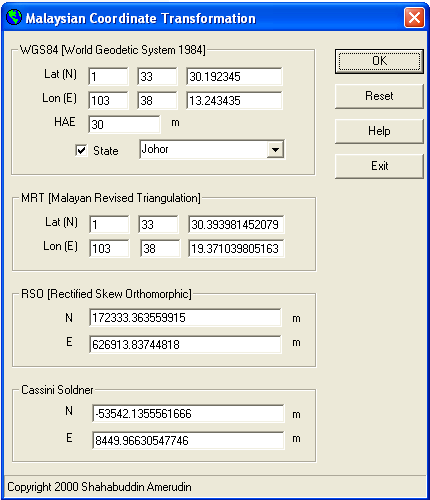
By Shahabuddin Amerudin

Geographic Information System (GIS) software has significantly advanced the way we approach mapping and spatial analysis, providing essential tools for converting between various coordinate systems. One of the key innovations in this field is the Malaysian Coordinate Transformation Program, developed in 1998 at Universiti Teknologi Malaysia (UTM). This program remains a crucial tool for professionals working with geospatial data in Malaysia. This article offers an in-depth exploration of the coordinate transformation process from the global WGS84 system to the local Malaysian systems, such as the Malayan Revised Triangulation (MRT), Rectified Skew Orthomorphic (RSO), and Cassini-Soldner systems.

Understanding Coordinate Systems and Datums

To appreciate the Malaysian Coordinate Transformation Program, it is essential to understand the coordinate systems and datums involved. The World Geodetic System 1984 (WGS84) is a global coordinate reference system used by the Global Positioning System (GPS). Developed by the U.S. Department of Defense, WGS84 is based on the GRS80 ellipsoid, which approximates the Earth’s shape (National Geospatial-Intelligence Agency, 2014). This system serves as the foundation for most GPS-based navigation and mapping activities worldwide.

In contrast, the Malayan Revised Triangulation (MRT) system is a local geodetic system used specifically in Peninsular Malaysia. Established in the mid-20th century, MRT is based on the Modified Everest ellipsoid, chosen for its suitability to the region’s topography (Ibrahim & Rashid, 1998). MRT was the standard for topographical and cadastral mapping in Malaysia before the widespread adoption of global systems like WGS84.

The Rectified Skew Orthomorphic (RSO) projection is a specialized map projection used primarily for topographical mapping in Malaysia. Developed based on Hotine’s theory in 1947, the RSO projection is an oblique Mercator projection that maintains conformality while minimizing distortion along a selected central line (Hotine, 1947). This projection is tailored for the Malaysian peninsula and is still used in many national mapping projects.

The Cassini-Soldner projection, on the other hand, is a cylindrical and transverse map projection historically used for cadastral mapping in Malaysia. Each state in Peninsular Malaysia traditionally had its own Cassini-Soldner system, with unique origins to minimize distortion within the state (Department of Survey and Mapping Malaysia [DSMM], 1974). Although its use has declined with the introduction of modern systems, it remains significant in historical cadastral records.

Coordinate Transformation Process

The process of transforming coordinates from WGS84 to the Cassini-Soldner system involves several stages. This transformation ensures the accurate integration of GPS data with local surveying systems (DSMM, 1999).

First, the transformation from WGS84 to the local Malayan Revised Triangulation (MRT) system involves the use of the Bursa-Wolf mathematical model. This model accounts for differences in translation, rotation, and scale between datums. The transformation formula can be expressed as:

XMRT=XWGS84+Tx+(1+S)⋅(Rz⋅(YWGS84−Ty)−Ry⋅(ZWGS84−Tz))
YMRT​=YWGS84​+Ty​+(1+S)⋅(Rz​⋅(ZWGS84​−Tz​)−Rx​⋅(XWGS84​−Tx​))

where Tx,Ty,Tz are translation parameters, S is the scale factor, and Rx,Ry,Rz are rotation matrices (National Geospatial-Intelligence Agency, 2014). The MRT system uses the Modified Everest ellipsoid, with specific parameters for semi-major axis and flattening (Ibrahim & Rashid, 1998). Standard algorithms based on the Bursa-Wolf model are applied to carry out this transformation.

Next, the transformation from MRT to the Rectified Skew Orthomorphic (RSO) projection involves applying formulas from the Projection Tables for Malaya. This projection uses the same Modified Everest ellipsoid, ensuring consistency with MRT. The RSO projection system is anchored to specific geographical coordinates in Kertau, Malaysia. Parameters such as central meridian, scale factor, and false easting/northing from the Projection Tables are used to perform this transformation (Hotine, 1947).

Finally, transforming coordinates from RSO to the Cassini-Soldner system involves using the Cassini projection formulas. The Cassini-Soldner projection is cylindrical and transverse, with each state in Peninsular Malaysia having its own specific origins to minimize distortion. The transformation parameters include scale factors, translations, and origin adjustments specific to each state (DSMM, 1974).

The Malaysian Coordinate Transformation Program

Developed in 1998 using Microsoft Visual Basic 6, the Malaysian Coordinate Transformation Program addresses the need for converting coordinates between different systems. Although the program was created on the Windows XP platform, it remains a valuable tool for professionals working with older datasets recorded in these local systems. The program provides a one-way transformation capability, allowing users to convert coordinates from WGS84 to MRT, RSO, and Cassini-Soldner. It also supports state-specific Cassini-Soldner coordinate retrieval, making it highly relevant for land surveying, GIS mapping, and navigation.

Despite its age, the Malaysian Coordinate Transformation Program remains remarkably user-friendly, efficient, and effective. It stands as a testament to the lasting influence of early GIS technologies on contemporary geospatial practices in Malaysia. During the late 1990s, many GIS software solutions available at that time struggled with accurate coordinate transformations due to their lack of specific Malaysian transformation parameters, often relying instead on universal formulas that were inadequate for local requirements. The Malaysian Coordinate Transformation Program, developed with an understanding of these local nuances, provided a vital solution where others fell short.

The Malaysian Coordinate Transformation Program remains an essential tool for GIS professionals, offering reliable solutions for coordinate conversion in Malaysia. Its ability to bridge the gap between global and local geodetic systems ensures its continued relevance in integrating historical and modern geospatial data.

For further information or inquiries about this program, interested individuals can contact shahabuddin@utm.my.

Important Notice

This program is not compatible with newer datums, such as GDM2000, and is specifically tailored for earlier geodetic systems utilized in Malaysia. As the program was developed in 1998 using Microsoft Visual Basic 6 and Windows XP, users may encounter compatibility issues when running it on the latest versions of Windows.

References

Department of Survey and Mapping Malaysia (DSMM). (1974). Cassini-Soldner projections for cadastral surveying in Malaysia. Technical Report No. 74-3, Kuala Lumpur.

Hotine, M. (1947). The Rectified Skew Orthomorphic projection of the sphere. The Geographical Journal, 109(2), 97-107.

Ibrahim, M. F., & Rashid, K. A. (1998). Mapping Malaysia: The evolution of geodetic datums and projections. Malaysian Surveyor, 33(4), 22-35.

Department of Survey and Mapping Malaysia (DSMM). (1999). GPS cadastral survey guidelines Semenanjung Malaysia. Retrieved from https://www.jupem.gov.my/jupem18a/assets/uploads/files/pekeliling/a9684-sg-699.pdf

National Geospatial-Intelligence Agency. (2014). World Geodetic System 1984 (WGS84) Implementation Manual. Retrieved from https://www.nga.mil


Announcement

We are pleased to announce that the program, now over 25 years old, has benefited numerous users since its initial release. Many users have reached out to me directly via email for assistance, and I have been glad to support them. To make things more convenient, I am now offering this program to the public for free. Those interested can download it from the following link: http://bit.ly/2F6O1ZS. However, please review the following important information before using the program:

Geodetic Datum Support

This program was developed in 1998, based on the geodetic datums available at that time. Therefore, it may not support newer geodetic datums, such as GDM2000, or other recent updates in geospatial reference systems. If your work requires the use of modern datum systems, you may need to use alternative software that accommodates the latest requirements.

Windows Compatibility Issues

The program was created using Microsoft Visual Basic 6 for use on Windows XP, and as such, it may encounter compatibility issues when running on more recent versions of Windows, such as Windows 10 or Windows 11. If you encounter difficulties, here are a couple of solutions:

  1. Install missing libraries: Some required system components, such as the mscomctl.ocx library, may not be included in newer versions of Windows. To resolve this, you can follow the instructions provided here: https://www.windows10free.com/repair-how-to-install-mscomctl-ocx-missing-windows-10/.
  2. Manually download the mscomctl.ocx file: If the issue persists, you can manually download the mscomctl.ocx file from https://thegeekpage.com/mscomctl-ocx/ and follow the provided steps to register it on your system.

Legal Disclaimer

While this program is now freely available to the public, we do not provide any official support or updates. The program is distributed on an “as-is” basis, with no warranties of any kind. By using the program, you acknowledge that we are not liable for any inaccuracies, errors, or damages that may result, particularly given the program’s age and the potential for compatibility issues with modern operating systems.

We hope the program proves useful to you. Please use it responsibly and at your own discretion.

Sunday, Oct. 6, 2024