
Tag: GIS
Development of Web-Based Application for Shapefile Coordinate System Conversion for Malaysia
By Elysonia Alim and Shahabuddin Amerudin It is difficult to process GIS vector data when they are not aligned with one another. The need for different coordinate systems rose from the fact that some ... Read More
Development of Web-Based Application for Shapefile Coordinate System Conversion for Malaysia
Elysonia Alim and Shahabuddin Amerudin Department of Geoinformation, Faculty of Geoinformation and Real Estate, Universiti Teknologi Malaysia, 81310 Skudai, Johor, Malaysia Email: elysoniaalim@gmail.c... Read More
Development of Web-Based Application for GIS Data Format Coordinate System Conversion
By Elysonia Alim and Shahabuddin Amerudin (Supervisor) Unpublished 2018 4th Year Undergraduate Project’s Technical Paper It is difficult to process GIS vector data when they are not aligned with... Read More
GIS research topics to explore
spatial computing infrastructure, spatial cognitive assistance, volunteering geographic information (VGI), GPS-denied environment, statistically significant spatiotemporal pattern mining, mobile econo... Read More
Top 10 Benefits of Geographic Information Systems (GIS)
1. IMPROVED COMMUNICATION Through the creation of rich maps and hi-tech communication systems, GIS has greatly assisted in improving communication. It has improved communication between different depa... Read More
Google Summer of Code Projects: Open Source Geospatial 4 every student
Are you are university student who has solid programming skills, geospatial knowledge and is continuously aiming to become better at developing open source software? Then you are in for a great summer... Read More
Pelajar Pascasiswazah atau Pembantu Penyelidik di dalam bidang GIS
Mencari seorang pelajar Pascasiswazah (Master atau PhD) atau Pembantu Penyelidik untuk menjalankan penyelidikan berkenaan dengan “APLIKASI AGENT-BASED MODELLING (ABM) DAN GEOGRAPHICAL INFORMATIO... Read More
Pembentangan Hasil Laporan Kajian Aplikasi Pemetaan Jenayah Juvana Menggunakan GIS
Putrajaya, 20 April 2016. Satu pembentangan laporan akhir kajian aplikasi pemetaan jenayah juvana di Semenanjung Malaysia menggunakan GIS telah dilaksanakan di Aras 36, Kementerian Pembangunan Wanita,... Read More
Future trends in geospatial information management: the five to ten year vision
A new report setting out the five to ten year vision of the rapidly growing geospatial information industry has been published by the United Nations Committee of Experts on Global Geospatial Informati... Read More
Diperlukan Pelajar Pascasiswazah atau Pembantu Penyelidik
Mencari seorang pelajar pascasiswazah atau pembantu penyelidik untuk menjalankan penyelidikan berkenaan dengan “APLIKASI AGENT-BASED MODELLING (ABM) DAN GEOGRAPHICAL INFORMATION SYSTEM (GIS) UNT... Read More
Postgraduate or Research Assistant Needed!
Looking for a postgraduate or research assistant for conducting a research on “USING AGENT-BASED MODELLING (ABM) AND GEOGRAPHICAL INFORMATION SYSTEM (GIS) FOR ANALYSING AND PREDICTING CRIME PATT... Read More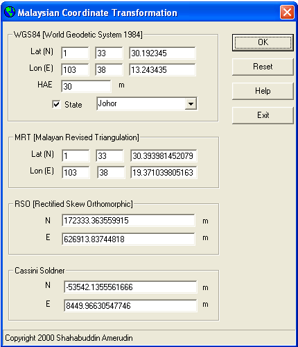
Malaysia Coordinate Transformation Program
By Shahabuddin Amerudin Geographic Information System (GIS) software has significantly advanced the way we approach mapping and spatial analysis, providing essential tools for converting between vario... Read More
Mapping of Social Media
Software companies are integrating geographic information systems (GIS) technology and social media to map people’s tweets and other social media platforms with geospatial data. This pairing has bee... Read More- 12 of 12
- « Previous
- 1
- …
- 10
- 11
- 12
