
Tag: map
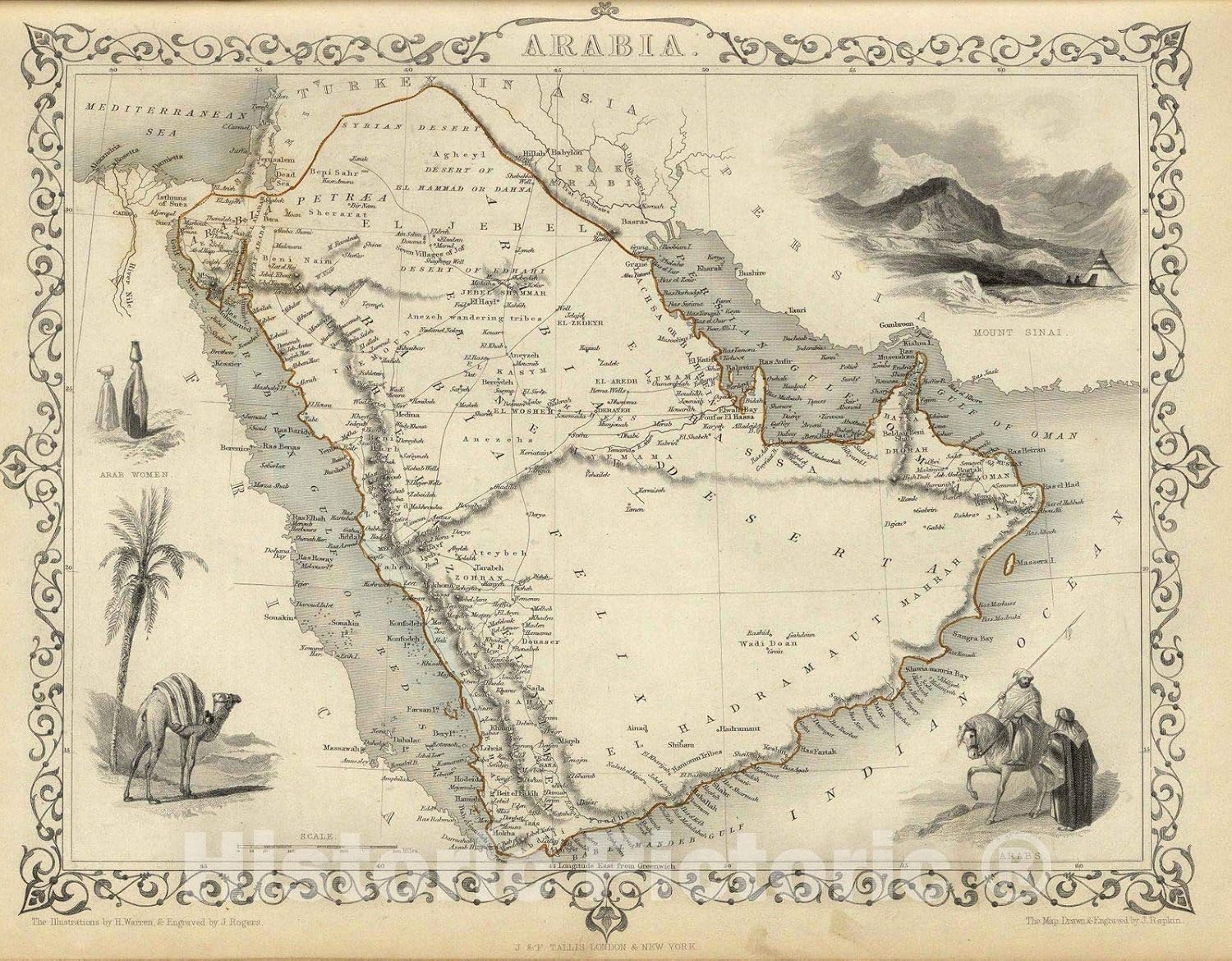
Implementing a Comprehensive Atlas Documenting the Life of Prophet Muhammad
By Shahabuddin Amerudin Introduction The documentation of the Prophet Muhammad’s life has historically been preserved through manuscripts, biographies (Sirah), and religious texts such as Hadith... Read More
Eyes in the Sky: Satellites Capture Devastation in Global Conflict Zones
By Shahabuddin Amerudin Recent satellite imagery has unveiled stark and vivid evidence of destruction and displacement in some of the world’s most volatile regions. The detailed images, compiled... Read More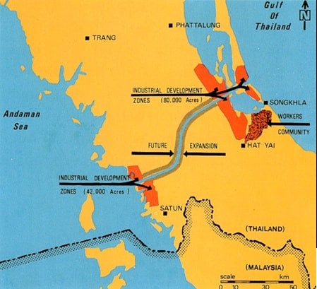
Thailand’s Industrial Development Zones: A Potential Game-Changer for Southeast Asia
The development of industrial development zones (IDZs) in southern Thailand is poised to have a significant impact on the economic landscape of Southeast Asia, particularly for neighboring countr... Read More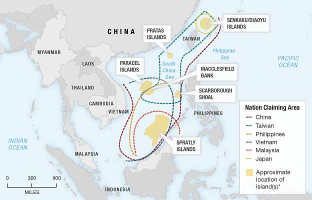
The South China Sea: A Maritime Hotspot
The provided image vividly illustrates the complex territorial disputes surrounding the South China Sea. This region, rich in natural resources, has become a focal point of contention a... Read More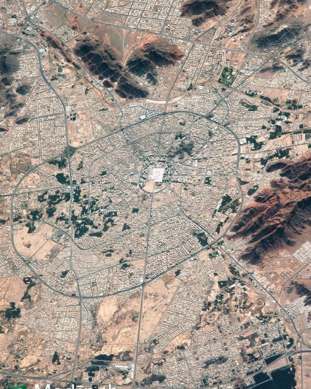
The Satellite Image of Medina: A Glimpse into the Heart of Islamic History
By Shahabuddin Amerudin The satellite image provided offers a breathtaking aerial view of Medina, one of the holiest cities in Islam. Located in the Hejaz region of Saudi Arabia, Medina is a city stee... Read More
Peta Bangunan | Building Map | FABU UTM
Oleh Shahabuddin Amerudin Pada 1 Julai 2018, Universiti Teknologi Malaysia (UTM) melihat pencapaian sejarah baru dengan penggabungan dua fakulti yang berprestij, iaitu Fakulti Alam Bina (FAB) dan Faku... Read More
The Enigmatic 1876 Perak Map
In 1876, a Malay map of Perak, based on W.E. Maxwell’s notes and sourced from MS 46943 at the Royal Asiatic Society in London, was published in Barbara Andaya’s work, “Perak: The Abo... Read More
The Unconventional Malay Map
By Shahabuddin Amerudin In the world of cartography, where precision and accuracy are highly valued, there exists a fascinating anomaly known as the “Malay Map.” This mysterious map, devoi... Read More
Addressing Common Challenges in Creating Study Area Maps in Thesis Writing
By Shahabuddin Amerudin Introduction Geographic Information Systems (GIS) plays an indispensable role in various fields, including environmental science, urban planning, and public health. For GIS stu... Read More
Creating an Effective Study Area Map in GIS
By Shahabuddin Amerudin Introduction Geographic Information Systems (GIS) play a pivotal role in modern spatial analysis, helping us understand and visualize complex spatial data. Among the fundamenta... Read More
Map Elements: The Building Blocks of Spatial Understanding
Maps are powerful tools for conveying information about our world. Whether you’re exploring a city, planning a road trip, analyzing data, or conducting scientific research, maps provide a visual... Read More
Cartography: Navigating the World Through Maps
Maps are more than mere navigational tools; they are the result of the fascinating blend of science and art known as cartography. Cartography, often described as the science and art of mapmaking, enco... Read More
Pembangunan Sistem Pengurusan Tanah Perkuburan Berasaskan GIS
Oleh Shahabuddin Amerudin Pembangunan Laman Web Tanah Perkuburan Islam Kampung Melayu Kangkar Pulai dijalankan melalui pendekatan kitar hayat pembangunan sistem (SDLC), yang terdiri daripada lima fasa... Read More
Developing Web Map-Based Applications
By Shahabuddin Amerudin Introduction Web map-based applications have transformed how we interact with geographic information, enabling us to explore, analyze, and visualize data on interactive maps. T... Read More
Designing and Developing a Web Map-based Muslim Cemetery System
By Shahabuddin Amerudin Introduction A web map-based cemetery system typically utilizes a GIS (Geographic Information System) to display a map of the cemetery and the location of graves within it. Use... Read More
