By Shahabuddin Amerudin
In the vibrant city of Nusantara, nestled between towering skyscrapers and bustling streets, stood the headquarters of GeoSmart Solutions, a leading GIS firm. Among its talented employees was Ahmad, a brilliant System Analyst with a passion for technology, geography, and a penchant for turning ideas into reality.
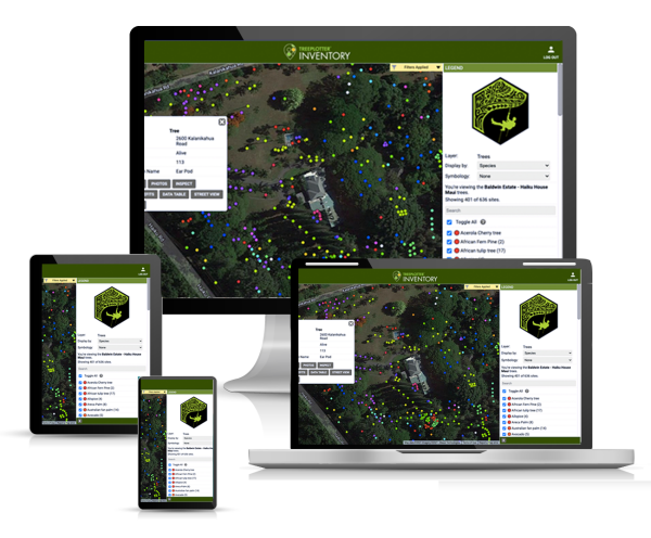
Ahmad was entrusted with leading a remarkable team on an ambitious project: the development of an innovative GIS application that would redefine how tree information was collected, analyzed, and utilized. This application would seamlessly integrate a cloud-based web platform with both iOS and Android mobile devices, enabling users to capture intricate tree data with submeter precision using their smartphones.
The journey began with a brainstorming session that crackled with excitement. Ahmad and his team huddled in the sleek conference room, sketching out visions of a cutting-edge application that would blend powerful technology with environmental stewardship. The challenge was immense, but Ahmad’s leadership inspired the team to forge ahead.
To lay a solid foundation, the team chose to leverage open-source tools. They designed a captivating web-based map using Leaflet, ensuring a user-friendly interface and fluid navigation. The heart of the application, the online database powered by MySQL, was meticulously constructed to handle vast amounts of geospatial data collected from the field.
As lines of code transformed into functional features, the team unveiled a host of impressive functionalities. The dynamic visualization feature breathed life into the maps, allowing users to interact with the data in real time. A comprehensive dashboard provided an at-a-glance overview of critical metrics, aiding decision-makers in shaping urban green spaces effectively.
Spatial analysis tools were crafted with precision, empowering users to conduct intricate geospatial calculations. Clusters of trees, trends in vegetation growth, and patterns of disease outbreaks could be deciphered with a few clicks. The application was evolving into a veritable powerhouse of environmental insights.
The most thrilling phase, however, was the integration of AI for advanced analysis. Ahmad collaborated closely with data scientists to develop machine learning models that predicted not only tree growth and health but also the potential spread of diseases. The algorithms digested copious amounts of data, unveiling trends that human eyes might miss. The marriage of AI and GIS was poised to bring about a paradigm shift.
As months of intensive development came to a close, the team was consumed by both anxiety and exhilaration. Field trials were launched, putting the application’s accuracy and reliability to the test. The city’s parks, avenues, and botanical gardens transformed into testing grounds, with users capturing tree data with precision that was once deemed impossible.
And then, the day arrived—the day the GIS application was ready to be unveiled to the world. The launch event was a culmination of creativity, innovation, and sheer determination. The presentation of the application left the audience in awe, and excitement rippled through the room as the first downloads began.
Users across Nusantara embraced the application with fervour. Urban planners marveled at its potential to inform city development plans. Environmentalists saw an ally in their efforts to preserve green spaces. Scientists reveled in the wealth of data for research. The city’s trees, once overlooked, became stars of their own story.
As time passed, Ahmad looked back at the tumultuous yet triumphant journey. The application’s impact had exceeded all expectations, fostering a greener, more sustainable urban landscape. Ahmad’s team continued to refine the application, incorporating user feedback and pushing the boundaries of technology and GIS.
Through the collaboration of visionaries, analysts, data scientists, and users, the GIS application stood as a testament to the power of innovation. The story of Ahmad and his team echoed in the city’s parks, streets, and botanical gardens—a tale of how a single idea, when nurtured by dedication and expertise, could grow into something that changed the world.
