By Shahabuddin Amerudin
Abstract
This paper delves into the realm of geospatial data processing, highlighting the amalgamation of Python scripting and advanced deep learning techniques for object detection. The resulting synergy offers an avenue to streamline complex tasks within this domain. The focus of this work is on the automation of building footprint extraction from aerial imagery using these integrated methodologies.
Automated Building Footprint Extraction via Deep Learning Techniques
Consider a scenario where the conventional approach of manually delineating building footprints from newly acquired aerial imagery demands weeks of laborious effort. Conversely, a technologically empowered approach leverages Python scripting in conjunction with deep learning for object detection. This paradigm shift not only improves operational efficiency but also obviates the need for labor-intensive manual interventions.
Efficiency in Object Detection
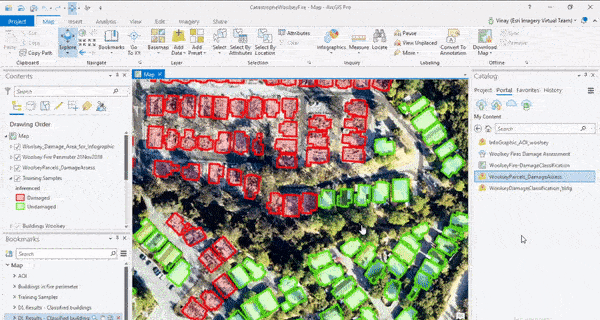
Human cognitive abilities can rapidly identify objects within images, often accomplished within a mere 5 seconds. This cognitive phenomenon can be emulated computationally through object detection, a technique where computers discern and localize objects within images. Despite the requirement for substantial training data and meticulous labeling, this goal is attainable. Esri, a renowned GIS technology enterprise, introduces pre-trained deep learning models termed DLPKs (deep learning packets) available on the ArcGIS Online platform. These models excel in recognizing diverse elements, including building footprints, vehicles, pools, solar panels, and roads within aerial imagery.
Practical Implementation
Initiating this transformative process requires specific prerequisites. These include access to ArcGIS Pro supplemented with the Image Analyst Extension, as well as aerial imagery featuring approximately 6-inch resolution. The ensuing steps provide a comprehensive guide for harnessing the capabilities of pre-trained models:
- Acquisition of Deep Learning Library Installers: Retrieve and install the Deep Learning Library Installers from the dedicated GitHub repository (https://github.com/Esri/deep-learning-frameworks/blob/master/README.md).
- Selection of Appropriate DLPK: Explore ArcGIS Online’s living atlas to identify the relevant DLPK suited for the intended object extraction task, such as building footprint identification.
- Integration of Aerial Imagery: Launch the ArcGIS Pro Project and import the targeted aerial imagery.
- Execution of Object Detection: Access the Geoprocessing window and select “Detect Objects Using Deep Learning.”
- Configuration of Object Detection: Specify the relevant raster image as input, provide an output name, and reference the downloaded DLPK. The tool will automatically populate the required parameters.
- Initiation of Automated Extraction: Commence the process by activating the “Run” button, subsequently witnessing the automated delineation of building footprints.
Overcoming Challenges and Enhancing Results
While maintaining optimistic expectations, acknowledge that processing speed is influenced by geographical extent and building density. It is recommended to perform preliminary tests on smaller image segments prior to achieving desired outcomes. Additionally, note that resulting building footprints might exhibit curvature and lack geometric precision. To address this, the “Regularize Building Footprints” Geoprocessing tool can rectify curvature issues by enforcing right-angle conformity (Fisher, 2021).
An optimization technique involves employing Model Builder to partition extensive raster images into manageable squares, thereby enhancing performance by processing a reduced dataset. Concluding this workflow, the merging of inferred building footprints into a cohesive layer is straightforward.
Performance Advantages and Future Prospects
The presented approach demonstrates operational efficiency, optimally utilizing computational hardware and system resources. Personal experience suggests the feasibility of background processing for an entire county over several days, concurrently managing other computer tasks (Fisher, 2021).
For those seeking in-depth engagement, the ArcGIS Pretrained Models documentation (https://doc.arcgis.com/en/pretrained-models/latest/get-started/intro.htm) offers a comprehensive resource for delving into the intricacies of these pre-trained models and their potential applications.
Reference
Fisher, C. (2021). Artificial Intelligence in GIS or “GeoAI”. [Online] Available at: https://www.linkedin.com/pulse/artificial-intelligence-gis-geoai-chase-fisher/ (Accessed: 19 August 2023).
Suggestion for Citation:
Amerudin, S. (2023). Simplifying Automated Building Footprint Extraction with Deep Learning in GIS. [Online] Available at: https://people.utm.my/shahabuddin/?p=6690 (Accessed: 20 August 2023).
