In today’s data-driven world, the fusion of technology, data analysis, and spatial understanding has revolutionized how we perceive and interact with our surroundings. This transformation is epitomized in the harmonious relationship between cartography and Geographic Information Systems (GIS) study. While cartography is the age-old science and art of mapmaking, GIS is a technology-based system that captures, stores, analyzes, and manages spatial data. Together, they form a powerful alliance that empowers us to explore, comprehend, and make decisions about the world around us. In this article, we delve into the intricate dance of cartography within the realm of GIS study.
Visualizing the World: The Role of Cartography in GIS
Spatial Data Visualization
At the heart of GIS lies the concept of spatial data. Whether it’s tracking the movements of wildlife, mapping urban land use, or assessing disaster risk, GIS professionals deal with a wealth of spatial information. Here, cartography emerges as the beacon of clarity in the complex world of data. Cartographic principles come to the forefront, guiding the creation of maps that transcend mere visualizations. These maps are designed to effectively communicate intricate spatial information, making complex data accessible to both experts and the general public.
Map Design and Production
In GIS, maps are not just utilitarian tools; they are instruments of insight. Cartography provides the foundation for designing maps that transcend functional boundaries. Cartographers within GIS study employ their expertise to select the most suitable map projections, scales, symbols, colors, and labeling conventions. The result is a map that is more than just a representation; it’s an informative and visually appealing piece of artistry. These maps serve as potent conveyors of data, offering a tangible perspective on the information they represent.
Data Layer Representation
GIS professionals often find themselves juggling multiple layers of spatial data. From land parcels to transportation networks, each layer carries its unique set of spatial attributes. Cartography lends a helping hand by allowing these data sources to harmoniously coexist on a single map. This layering capability brings spatial data to life, enabling users to grasp how various datasets interrelate in the spatial realm.
Thematic Mapping
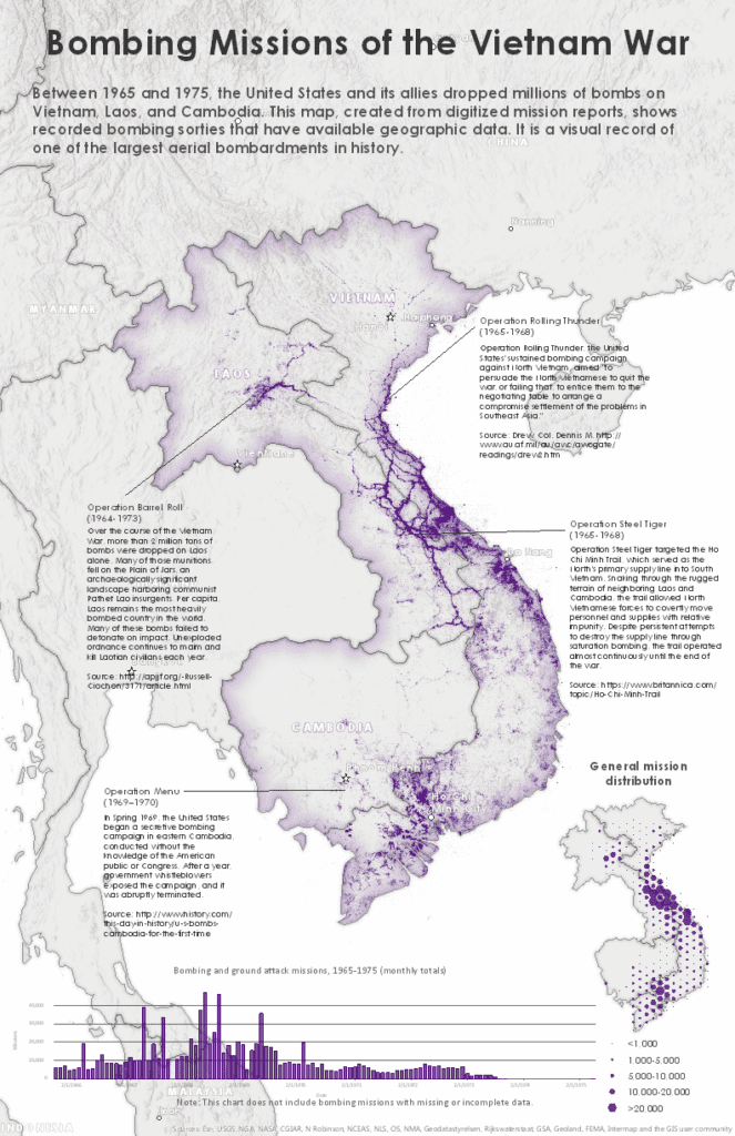
Thematic mapping, the practice of creating maps that emphasize specific themes or patterns in spatial data, is a staple in GIS study. Whether it’s highlighting population distribution, land use, environmental factors, or any other geographic phenomenon, cartography principles guide the design of thematic maps. These maps, often loaded with symbolism and artistic nuances, transcend the role of data representation; they become tools of storytelling and understanding.
Geospatial Analysis
GIS is a realm of numbers, statistics, and spatial relationships. It’s about unveiling patterns, making predictions, and informing decisions. Here, geospatial analysis takes center stage. Cartography, in turn, plays a crucial role in translating the results of these analyses into visual forms that can be readily comprehended. Think of heatmaps that reveal population density, density maps that illuminate disease outbreaks, or flow maps that unveil transportation patterns. These are all cartographic representations born from geospatial analysis.
Map Layout and Printing
The art of mapmaking extends beyond the digital realm. When it’s time to commit GIS results to paper, cartography steps in. Cartographic principles guide the arrangement of map elements on a page, dictating the positioning of legends, scale bars, north arrows, and text. This meticulous attention to detail ensures that printed maps are not just informative but also adhere to standardized conventions, making them universally understandable.
Interactive Mapping
In today’s digital age, maps have transcended the static confines of paper. Modern GIS often revolves around interactive digital mapping, where users can explore and query spatial data dynamically. In this arena, cartography takes on a new dimension. It extends into the design of web-based maps and interactive applications, ensuring that users can interact with and extract insights from spatial data effectively.
Customization
No two GIS projects are identical. Each one carries its unique set of goals, challenges, and stakeholders. GIS professionals frequently find themselves customizing maps to align with specific project requirements or stakeholder preferences. Cartographic knowledge empowers them to tailor maps precisely, making the information more accessible, actionable, and relevant to the task at hand.
Quality Control
In the realm of GIS, data accuracy is paramount. Errors or inconsistencies in spatial data can lead to misinformation and misguided decisions. Cartographic principles offer a lens through which GIS professionals can scrutinize and rectify data issues. Whether it’s verifying the precision of data points, ensuring symbol consistency, or enhancing visual clarity, cartography plays a crucial role in quality control.
Spatial Decision-Making
GIS is not just about numbers and maps; it’s a catalyst for spatial decision-making. It aids in answering critical questions and shaping policies. In this context, cartography becomes the bridge between data analysis and effective communication. Well-designed maps convey complex spatial information in a format that is not just easy to understand but also aids in making informed choices based on geographic data.
Public Communication
Beyond the realm of experts, GIS often extends to public communication and engagement. Maps are used to convey complex information to the masses or various stakeholders. This is where cartography excels. It takes intricate data and presents it in an accessible and compelling way. Cartography transforms data into stories, fostering better public understanding, engagement, and decision-making.
The Symbiotic Union of Cartography and GIS
In summary, cartography and GIS study are not isolated fields; they are deeply interconnected. Cartography brings a profound layer of meaning and insight to GIS, turning data into understanding. It bridges the gap between raw data analysis and the effective communication of spatial information. This symbiotic relationship enhances our ability to explore, analyze, and make informed decisions based on the complex world of geographic data. It underscores that in our journey to navigate the ever-evolving landscape of data, the art and science of cartography remain our trusted guides.
