Maps are powerful tools for conveying information about our world. Whether you’re exploring a city, planning a road trip, analyzing data, or conducting scientific research, maps provide a visual representation of spatial information. To make maps informative and user-friendly, cartographers use various map elements that serve as the building blocks of spatial understanding. In this comprehensive article, we’ll explore these essential map elements and their roles in map design and interpretation.
The Fundamentals of Map Elements
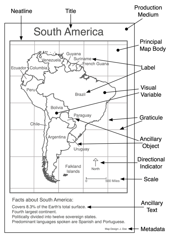
1. Title
- Role: The title is the map’s name and serves as a brief description of its content and purpose.
- Importance: It provides context and helps users understand what the map is about.
2. Legend (Key)
- Role: The legend explains the symbols, colors, and icons used on the map and their corresponding meanings.
- Importance: It enables users to interpret the map’s symbols and understand the data being presented.
3. Scale Bar
- Role: The scale bar indicates the relationship between distances on the map and actual distances on the Earth’s surface.
- Importance: It helps users estimate distances and understand the map’s level of detail.
4. North Arrow (Compass Rose)
- Role: The north arrow shows the orientation of the map, indicating which direction is north.
- Importance: It ensures that users can align the map with the real world’s cardinal directions.
5. Data Source Attribution
- Role: This element provides information about the source of the data used to create the map.
- Importance: It establishes the map’s credibility and allows users to verify the data’s reliability.
6. Inset Map
- Role: An inset map provides a smaller, detailed view of a specific area within the larger map.
- Importance: It offers context for regions of interest within a broader geographic context.
Spatial Representation Elements
7. Base Map
- Role: The base map depicts the foundational elements of the map, such as landforms, bodies of water, and major roads.
- Importance: It provides context for additional layers of information.
8. Data Layers
- Role: Data layers represent thematic information on the map, such as population density, land use, or geological features.
- Importance: Layers convey specific details and allow users to explore different aspects of the same area.
9. Contours (Topographic Maps)
- Role: Contours represent elevation changes and the shape of the terrain.
- Importance: They aid hikers, geologists, and land planners in understanding the landscape’s physical characteristics.
Labeling and Text Elements
10. Labels
- Role: Labels identify and name geographical features, such as cities, rivers, and mountains.
- Importance: They provide essential information and enhance map readability.
11. Annotations
- Role: Annotations add supplementary information, explanations, or remarks to the map.
- Importance: They clarify specific map details or convey additional insights.
12. Scale Text
- Role: Scale text indicates the map’s scale in a textual format (e.g., “1 inch = 1 mile”).
- Importance: It offers an alternative to the scale bar for conveying map scale information.
Aesthetic and Visual Elements
13. Colors
- Role: Colors are used to differentiate features, convey information, and enhance map aesthetics.
- Importance: Effective color choices can improve map interpretation and make it visually appealing.
14. Symbols and Icons
- Role: Symbols and icons represent specific features or phenomena on the map, such as trees, airports, or landmarks.
- Importance: They condense complex information into easily recognizable forms.
15. Line Styles
- Role: Line styles (e.g., solid, dashed, dotted) are used to depict linear features like roads, rivers, and boundaries.
- Importance: Line styles help users distinguish between different types of features.
16. Patterns and Hatching
- Role: Patterns and hatching are used for shading or filling areas to convey specific information, such as land use or vegetation.
- Importance: They add depth and detail to the map’s representation.
Interactive and Digital Elements
17. Interactive Features
- Role: Interactive maps include features like zoom, pan, clickability, and pop-up information windows.
- Importance: These features enable users to explore and interact with digital maps dynamically.
18. Data Layers Control
- Role: Users can toggle data layers on or off, customize their visibility, or adjust transparency.
- Importance: This flexibility allows users to focus on specific aspects of the map as needed.
Practical Considerations
19. Grids and Coordinates
- Role: Grids and coordinates help users pinpoint locations on the map with precision.
- Importance: They assist in navigation and precise data retrieval.
20. Insets for Map Series
- Role: Insets in map series show a collection of maps covering different areas or scales.
- Importance: They allow users to navigate through related maps efficiently.
Beyond Conventional Elements
21. 3D Elements
- Role: In 3D mapping, elevation, extrusion, and perspective can be added to create three-dimensional visualizations.
- Importance: These elements provide depth and realism to maps, particularly in terrain modeling.
Conclusion
In the world of mapmaking, these map elements are the cornerstones of effective spatial communication. They transform data into meaningful information, enabling users to navigate, analyze, and make decisions about the world around them. Whether it’s a paper map for tourists, a digital map for urban planners, or a thematic map for environmental scientists, these elements are the fundamental components that breathe life into maps. They represent the art and science of cartography, enriching our understanding of the complex and diverse landscapes that make up our planet.
