By Shahabuddin Amerudin
Abstract
Mineral exploration, a complex and high-stakes endeavor rife with uncertainties, is experiencing a paradigm shift through the integration of cutting-edge geospatial analysis and the revolutionary 4D-Geographic Information System (GIS). In this review, we unravel the profound impact of these technologies on mineral exploration, shedding light on their indispensable role in mitigating risks and significantly increasing the likelihood of discovering concealed mineral deposits. Our exploration traverses a spectrum of input datasets, encompassing remote sensing, exploration geochemistry, exploration geophysics, and geological indicators. Furthermore, we delve into the pivotal stages of user-guided interpretation and predictive modeling, which play a critical role in pinpointing promising exploration targets. Geospatial analysis, propelled by advanced technologies, emerges as a cornerstone in modern mineral exploration campaigns, vastly enhancing their prospects of success.
Introduction
Mineral exploration, often likened to a high-stakes gamble, is fraught with inherent uncertainties that escalate as exploration ventures into deeper and more intricate terrains. The pursuit of concealed mineral deposits adds further complexity to this endeavor. To confront these multifaceted challenges, Mineral Prospectivity Modeling (MPM) has emerged as an invaluable approach (Pour et al., 2023). MPM integrates data from diverse geophysical, geochemical, and geological surveys to craft predictive models of mineral prospectivity. However, the efficient management of the vast information generated by these surveys necessitates sophisticated techniques, with geospatial analysis standing out as a key player.
The Need for a 4D-GIS
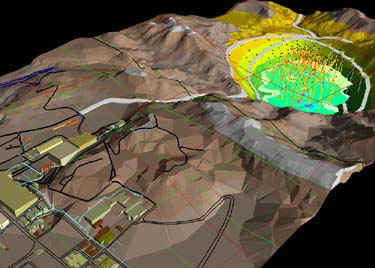
In the realm of contemporary mineral exploration, the utilization of a 4D-Geographic Information System (GIS) has become nothing short of imperative. A 4D-GIS is a sophisticated platform that extends beyond traditional 2D and 3D GIS by introducing the temporal dimension into spatial analysis (Pour et al., 2023). This temporal aspect, often referred to as the fourth dimension (T), represents a groundbreaking leap in our understanding of the dynamic nature of geological processes and mineralization.
This comprehensive system serves as an invaluable foundation for the analysis, visualization, and integration of a wealth of spatial data, including geological, geochemical, and geophysical information. It brings together not only the X and Y coordinates (longitude and latitude) but also the Z-axis for elevation (height) and the crucial temporal aspect, effectively making it a four-dimensional space. This integration of spatial and temporal dimensions empowers geoscientists to unravel intricate geological processes and monitor changes in mineralization over time. The utilization of 4D-GIS stands as a testament to the evolution of mineral exploration techniques.
Input Datasets
A 4D-GIS draws from a diverse range of input datasets, each contributing a unique piece to the mineral exploration puzzle. These datasets encompass remote sensing data collected from satellites or aircraft, providing a bird’s-eye view of geological features and alterations (Mars & Rowan, 2006). Exploration geochemistry data, involving the chemical analysis of samples from various media, unveils subtle geochemical anomalies indicative of undiscovered mineral deposits (Carranza, 2008). Exploration geophysics data, rooted in disparities in physical properties, aids in pinpointing various types of mineral deposits (Knox-Robinson & Wyborn, 1997). Geological indicators, identified through techniques like GPS, mineralogy analysis, and X-ray diffraction (XRD), offer crucial insights into host rocks, hydrothermal alteration zones, and geological structures.
Temporal Dimension (T)
The introduction of the temporal dimension (T) in GIS allows geoscientists to monitor and analyze the dynamic changes in geological features and mineralization over time. This temporal aspect is instrumental in tracking the evolution of hydrothermal systems and alterations in mineral deposits due to environmental factors (Singer & Kouda, 1999).
User-Guided Interpretation of Datasets: Unveiling the Mineral Puzzle
Interpreting datasets in the realm of geospatial analysis resembles solving a complex mineral puzzle. While traditional descriptive deposit models have provided valuable insights into local-scale mineralization attributes, they may not offer a comprehensive view applicable to all exploration scenarios. To address this challenge, the mineral systems framework emerges as a powerful tool, offering a scale-independent, process-oriented perspective (Ericsson, 2012).
In this framework, data from various sources, such as remote sensing, geochemistry, and geophysics, are distilled into exploration targeting criteria. These criteria extend beyond mere descriptions of mineral deposits, delving into the underlying geological mechanisms that give rise to them. By comprehending these geological processes, geoscientists can identify prospective areas where similar processes may have occurred.
This approach often results in the creation of exploration targeting criteria in two or three dimensions. These criteria serve as invaluable guides in the search for mineral deposits. Instead of relying solely on empirical observations, mineral exploration benefits from a systematic understanding of where and how certain minerals are likely to form. Thus, the user-guided interpretation of datasets becomes a fundamental step in maximizing the efficacy of geospatial analysis in mineral exploration.
Predictive Modeling: Illuminating the Exploration Path
Predictive modeling assumes the role of a guiding light in the realm of mineral exploration, shedding light on the path to potential discoveries. It transforms the wealth of information gleaned from diverse datasets into actionable insights. There are two primary mathematical frameworks in this process: knowledge-driven models (Singer & Kouda, 1999) and data-driven models.
Knowledge-Driven Models: In the knowledge-driven approach, accumulated geological knowledge serves as the foundation. Geologists and mineralogists, leveraging their expertise, construct models encapsulating geological conditions conducive to mineralization. These models often involve identifying key geological indicators, such as specific rock types or structural features, to map areas with high mineral potential.
Data-Driven Models: In contrast, data-driven models harness computational algorithms and machine learning to process extensive datasets, unveiling patterns and correlations that may elude human observation. These models analyze multidimensional data from sources such as geochemistry and geophysics to identify subtle signals indicative of concealed mineralization. However, rigorous validation is necessary to ensure their reliability.
The outcomes of predictive modeling typically manifest as 2D or 3D maps, providing visual representations of areas with varying degrees of favorability for mineral deposits. These maps serve as starting points for further exploration activities, enabling geologists and exploration teams to prioritize specific regions for in-depth investigations, including drilling or trenching. Consequently, predictive modeling streamlines the exploration process, enhancing both efficiency and cost-effectiveness.
Conclusion
Geospatial analysis, particularly within the framework of a 4D-GIS system, emerges as a linchpin in mitigating the risks inherent in mineral exploration. By amalgamating and interpreting diverse datasets encompassing remote sensing, exploration geochemistry, exploration geophysics, and geological indicators, alongside the deployment of predictive modeling techniques, contemporary exploration campaigns significantly elevate their odds of locating valuable mineral deposits. This transformative integration of technology and geoscience paves the way for a new era in mineral exploration, promising more informed and successful endeavors that will shape the future of the mining industry.
References
- Carranza, E. J. M. (2008). Geochemical anomaly and mineral prospectivity mapping in GIS. Elsevier.
- Ericsson, T. (2012). Evaluation of mineral prospectivity: A review. Ore Geology Reviews, 55, 201-216.
- Knox-Robinson, C. M., & Wyborn, D. (1997). Discovery of mineral deposits through regional-scale integration of geological, geophysical and remote sensing data. Ore Geology Reviews, 12(1-3), 67-88.
- Mars, J. C., & Rowan, L. C. (2006). Regional mapping of phyllic-argillic alteration in propylitic rocks using advanced spaceborne thermal emission and reflection radiometer (ASTER) data at Cuprite, Nevada. Economic Geology, 101(8), 1611-1627.
- Pour, A. B., Parsa, M., & Eldosouky, A. M. (2023). Introduction to mineral exploration. Geospatial Analysis Applied to Mineral Exploration, 1–16. https://doi.org/10.1016/b978-0-323-95608-6.00001-9.
- Singer, D. A., & Kouda, R. (1999). Mineral exploration: principles and applications. Society for Mining, Metallurgy, and Exploration.
Suggestion for Citation:
Amerudin, S. (2023). Geospatial Analysis and 4D-GIS in Mineral Exploration. [Online] Available at: https://people.utm.my/shahabuddin/?p=7106 (Accessed: 13 September 2023).
