By Shahabuddin Amerudin
Geographic Information Systems have come a long way from their origins as specialized mapping tools used primarily by government agencies and academic researchers. Today’s GIS landscape represents a vibrant ecosystem of technologies that touch virtually every industry and aspect of modern life. As we look at the state of GIS in early 2025, several key trends and developments stand out that are reshaping how we collect, analyze, and visualize spatial data.
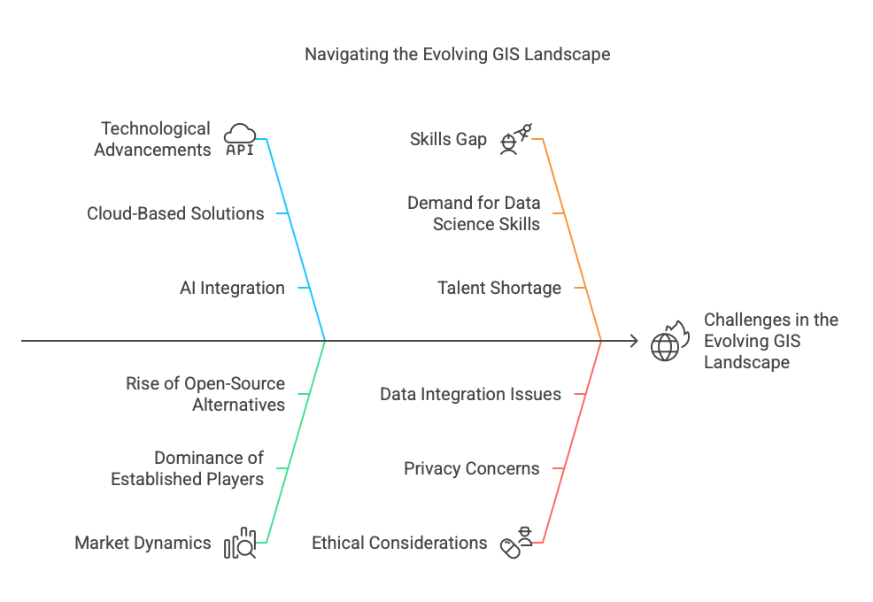
The market continues to be dominated by established players like Esri, whose ArcGIS platform has successfully navigated the transition from traditional desktop software to a comprehensive ecosystem spanning desktop, server, web, and mobile environments. ArcGIS Pro has now firmly established itself as the flagship product, leaving ArcGIS Desktop as a legacy system that fewer organisations maintain. What makes Esri’s continued dominance remarkable is their ability to adapt to changing technological paradigms while maintaining backward compatibility with decades of existing work.
Meanwhile, the open-source GIS community has matured significantly, with QGIS emerging as a powerful alternative that rivals commercial solutions in many aspects. The latest iterations of QGIS offer performance improvements and sophisticated analysis capabilities that were once the exclusive domain of expensive proprietary software. This democratization of GIS technology has expanded access to spatial analysis tools for smaller organizations, developing nations, and individual researchers who might otherwise be priced out of the market.
Perhaps the most transformative shift in recent years has been the move toward cloud-based GIS solutions. Organizations increasingly recognize the advantages of offloading the burden of maintaining complex geospatial infrastructure to specialized cloud providers. Services like ArcGIS Online, CARTO, and custom implementations on major cloud platforms allow users to scale resources up or down as needed, making it possible to process massive datasets that would overwhelm traditional hardware. This shift mirrors broader trends in enterprise IT, where the flexibility and cost efficiencies of cloud computing have become too compelling to ignore.
The integration of artificial intelligence with geospatial analysis represents another frontier that has moved from experimental to practical in recent years. Machine learning algorithms now routinely extract features from satellite imagery, identify patterns in spatial data, and generate predictions based on geographic variables. What once required painstaking manual digitization and interpretation can now be accomplished in hours or minutes through automated processes, though human expertise remains essential for validating and contextualizing these results.
Real-time GIS has emerged as a critical capability for organizations dealing with dynamic situations. From emergency management agencies tracking disaster responses to utilities monitoring service disruptions to transportation departments optimizing traffic flow, the ability to visualize and analyze spatial data as it’s generated provides actionable intelligence that wasn’t possible with traditional batch processing approaches. The proliferation of IoT sensors, mobile devices, and other location-aware technologies has created vast streams of spatial data that continue to drive innovation in this area.
The concept of digital twins—virtual representations of physical environments that update in real-time—has moved from theoretical to practical, particularly in urban environments and infrastructure management. Cities like Singapore, Barcelona, and Helsinki have implemented comprehensive digital twin projects that combine high-resolution 3D models with real-time sensor data, creating “living” representations of urban systems that can be used for planning, simulation, and day-to-day operations.
Business intelligence and GIS have become increasingly intertwined, with location intelligence now recognized as a critical dimension of business analytics. Retailers analyze customer movement patterns, insurers assess geographic risk factors, and logistics companies optimize delivery routes—all using specialized tools that combine traditional business metrics with spatial components. This convergence has created new opportunities for GIS professionals while simultaneously requiring them to develop skills in data science and business analytics.
The challenges facing the GIS community are as significant as the opportunities. Data integration remains difficult despite decades of standardisation efforts, with organisations still struggling to combine datasets from different sources with varying quality, formats, and update frequencies. Privacy concerns have intensified as location tracking becomes more pervasive, raising important ethical and legal questions about how spatial data should be collected, stored, and analyzed.
Perhaps the most pressing issue facing the industry is the skills gap. The demand for professionals who understand both GIS concepts and adjacent technologies like cloud computing, machine learning, and data science far exceeds the current supply. Universities and professional training programs are working to address this gap, but many organizations find themselves unable to fully capitalize on available technologies due to talent shortages.
As we look toward the future, the boundaries between GIS and other technologies will continue to blur. Location is increasingly recognised not as a specialised domain but as an essential dimension of nearly all data. The most successful organisations will be those that integrate spatial thinking throughout their operations rather than treating it as a separate function. The GIS systems of tomorrow will likely be less visible as distinct software packages and more embedded as capabilities within broader technology stacks and business processes.
The democratization of geospatial technology continues apace, with tools becoming more accessible to non-specialists. This trend promises to expand the impact of spatial analysis across fields, from climate science to public health to urban planning. As barriers to entry fall, we can expect to see innovative applications emerge from unexpected directions, driven by domain experts who previously lacked access to sophisticated spatial tools.
In this rapidly evolving landscape, both technology providers and users must remain adaptable. The fundamental principles of geographic analysis endure, but the tools, techniques, and applications continue to transform at an accelerating pace. Those who can bridge traditional GIS expertise with emerging technologies will find themselves at the forefront of this exciting field as it continues to reshape how we understand and interact with the world around us.
