By Shahabuddin Amerudin
Spatial Decision Support Systems (SDSS) have undergone significant transformation in recent years, evolving from basic mapping tools into sophisticated decision engines that integrate geospatial science, data analytics, and decision theory. This evolution represents a fundamental shift in how spatial problems are approached and resolved within Geographic Information Systems (GIS).
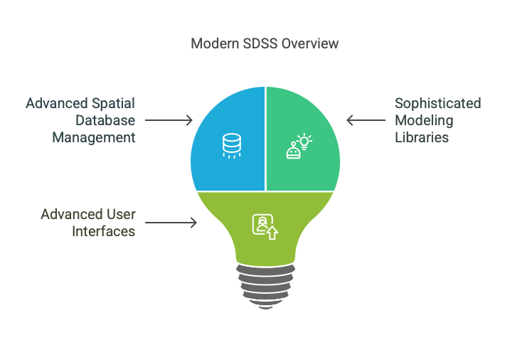
Contemporary SDSS Architecture
Modern SDSS implementations have matured beyond simple GIS add-ons to become comprehensive platforms that address complex spatial challenges. The architecture of these systems has developed considerably, typically incorporating three interconnected components:
- Advanced Spatial Database Management Systems now extend far beyond traditional GIS data storage capabilities. These systems manage massive datasets including real-time streams from IoT devices, daily satellite imagery updates, geolocated social media data, and complex 3D urban environment representations. Cloud-native architectures have become standard practice, enabling unprecedented scalability and processing power.
- Sophisticated Modeling Libraries have expanded well beyond basic projections. Contemporary SDSS incorporate machine learning algorithms for pattern detection, agent-based models simulating thousands of individual decision-makers interacting across landscapes, and cellular automata predicting emergent phenomena in urban growth patterns. Leading-edge systems now feature digital twins—complete virtual replicas of physical environments that can be manipulated to test various scenarios under different conditions.
- Advanced User Interfaces have been transformed by visualization technology breakthroughs. Static maps and basic charts have given way to immersive 3D visualizations, augmented reality capabilities that overlay projections onto physical spaces during stakeholder meetings, and interactive dashboards that update in real-time as parameters are adjusted. These interfaces increasingly support collaborative decision-making processes rather than serving technical specialists alone.
Practical Applications
Urban planning provides a compelling example of modern SDSS applications. When determining optimal locations for new public housing developments, contemporary systems model numerous interacting factors: existing transportation networks, school district capacities, proximity to employment centers, environmental justice considerations, flood zone projections under climate change scenarios, and neighborhood cultural significance. These comprehensive analyses help stakeholders visualize non-obvious trade-offs and identify unexpected synergies between seemingly competing priorities.
What distinguishes current SDSS implementations is their embrace of uncertainty. Earlier systems often presented deterministic outcomes, suggesting a misleading sense of predictive accuracy. Today’s platforms explicitly acknowledge the inherent uncertainties in spatial planning, employing techniques like Monte Carlo simulations to display ranges of possible outcomes with associated probabilities. This approach reflects a more sophisticated understanding that perfect prediction remains impossible in complex spatial systems.
Data Integration and Expansion
The data foundations supporting these systems have expanded dramatically. Beyond conventional GIS layers, modern SDSS integrate qualitative information such as community sentiment analyses from social media, cultural mapping data gathered through participatory processes, and indigenous knowledge systems that capture relationships with land often overlooked by conventional data models. This integration reflects growing recognition that effective spatial decisions must incorporate multiple knowledge systems beyond purely quantitative measures.
Application domains have similarly expanded. While urban and environmental planning remain core use cases, SDSS now support decisions in public health (pandemic response planning), climate adaptation (managed retreat from vulnerable coastlines), retail network optimization, humanitarian logistics, disaster response coordination, and national security.
Collaborative Decision Support
Perhaps most significantly, contemporary SDSS are increasingly designed to support collective rather than individual decision-making. These systems function as platforms where diverse stakeholders—each with different values, priorities, and expertise—can collaboratively explore scenarios, building shared understanding around complex spatial problems.
This evolution reflects a deeper shift in how spatial decisions themselves are conceptualized—not as technical puzzles awaiting sufficient processing power, but as complex social negotiations about possible futures that technology can inform but never fully resolve. As SDSS continue to develop, this human-centered approach to spatial decision support will likely become increasingly prominent in addressing the complex spatial challenges facing society.
