By Shahabuddin Amerudin
Introduction
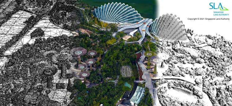
Singapore has been at the forefront of technological advancements in urban management and planning, with its ambitious initiative, Virtual Singapore. This project represents the world’s first country-scale digital twin, a 3D digital model designed to integrate real-time data, simulate urban environments, and improve decision-making processes. This article critically examines the development, benefits, and challenges of Virtual Singapore, highlighting its implications for future smart city developments.
Development and Technological Framework
The origins of Virtual Singapore date back to 2012 when the Singapore Land Authority (SLA) embarked on creating a national 3D map to enhance land use planning and disaster management (Singapore Land Authority, 2019). By 2019, SLA collaborated with Bentley Systems to refine the initiative, collecting over 25 terabytes of geospatial data through 160,000 high-resolution aerial photographs taken in a span of 41 days (IT Pro, 2021). Advanced technologies, including laser-scanning and AI-driven 3D modeling, were employed to create a highly detailed and accurate virtual replica of Singapore, with precision reaching up to 10 centimeters (OECD OPSI, 2022).
Applications and Benefits
Virtual Singapore has been instrumental in various domains, including urban planning, environmental sustainability, and public services. One of the most significant applications is in urban planning and infrastructure management, where authorities can simulate new developments, assess infrastructure projects, and optimize land use strategies (MingoThings, 2023). The platform allows for better visualization of construction impacts, helping planners anticipate congestion and environmental disturbances before they occur.
Additionally, Virtual Singapore plays a crucial role in environmental monitoring. By integrating real-time climate and topographical data, the model helps in assessing urban heat island effects, optimizing green spaces, and managing flood-prone areas (Infra Global, 2023). This feature enhances Singapore’s climate resilience by providing data-driven insights into environmental sustainability measures.
The digital twin is also vital for public service enhancements, particularly in traffic management, utility services, and emergency response planning (TechGov, 2023). By simulating pedestrian and vehicle movement patterns, authorities can implement efficient traffic flow strategies and optimize public transportation systems.
Challenges and Considerations
Despite its numerous advantages, Virtual Singapore also presents several challenges that must be addressed to ensure its sustainability and scalability.
One major issue is data privacy and security. Given the extensive amount of personal and infrastructural data integrated into the system, concerns regarding cybersecurity breaches and unauthorized data access remain paramount (VentureBeat, 2024). The implementation of robust data governance policies is essential to safeguard sensitive information and maintain public trust.
Another challenge is data integration and accuracy. Since the platform sources data from multiple agencies and technologies, ensuring consistency and reliability across datasets is a complex task. Data discrepancies can lead to inaccurate simulations, potentially undermining the effectiveness of urban planning strategies (VentureBeat, 2024).
Furthermore, the deployment of such an advanced digital infrastructure raises governance and policy implications. Issues such as data ownership, ethical considerations, and regulatory frameworks must be carefully addressed to balance innovation with responsible digital governance (UAL, 2024). Establishing transparent policies on data sharing and accountability will be critical in mitigating potential legal and ethical conflicts.
Conclusion
Singapore’s Virtual Singapore initiative exemplifies a forward-thinking approach to urban management and smart city innovations. While it offers significant benefits in planning, environmental monitoring, and public service optimization, challenges related to data governance, privacy, and accuracy must be tackled to ensure long-term success. As other cities explore similar digital twin technologies, balancing technological advancements with ethical and regulatory considerations will be key to realizing the full potential of smart urban environments.
References
Infra Global. (2023). Singapore’s digital twin: From science fiction to high-tech reality. Retrieved from https://infra.global
IT Pro. (2021). Mapping an entire country: Meet Singapore’s digital twin. Retrieved from https://www.itpro.com
MingoThings. (2023). How Singapore leads the way in urban planning with digital twin technology. Retrieved from https://www.mingothings.com
OECD OPSI. (2022). Virtual Twin Singapore. Retrieved from https://oecd-opsi.org
Singapore Land Authority. (2019). National 3D Mapping Initiative. Retrieved from https://www.sla.gov.sg
TechGov. (2023). 5 Things to Know About Virtual Singapore. Retrieved from https://www.tech.gov.sg
UAL. (2024). Assessing governance implications of city digital twin technology: A maturity model approach. Retrieved from https://ual.sg
VentureBeat. (2024). How Singapore created the first country-scale digital twin. Retrieved from https://venturebeat.com


