By Shahabuddin Amerudin
Introduction
Geographic Information Systems (GIS) have been a cornerstone of spatial analysis and decision-making for decades, fundamentally transforming how organizations understand and interact with geographic data. The traditional definition of GIS as a system for capturing, storing, managing, analyzing, and visualizing geographic information is rapidly becoming insufficient to describe its expanding capabilities. As technological advancements continue to reshape the geospatial landscape, GIS is evolving from a static mapping tool into a dynamic, intelligent ecosystem capable of autonomous analysis and predictive insights.
The global significance of this transformation is evident in the market projections. According to a comprehensive report by Grand View Research, the GIS market was valued at approximately $11.2 billion in 2023 and is projected to reach $29.3 billion by 2030, representing a compound annual growth rate (CAGR) of 14.7% (Grand View Research, 2023). This substantial growth reflects the increasing integration of advanced technologies such as artificial intelligence, machine learning, Internet of Things (IoT), and immersive technologies like augmented and virtual reality into geospatial systems.
Historical Evolution of Geographic Information Systems
The origins of Geographic Information Systems can be traced back to the 1960s, with Dr. Roger Tomlinson widely recognized as the “Father of GIS” for developing the Canada Geographic Information System (CGIS) in 1963. Initially conceived as a land management tool for the Canadian government, CGIS represented a groundbreaking approach to digital spatial data management. Dr. Tomlinson’s work laid the foundational framework for what would become a revolutionary technology across multiple disciplines.
The evolution of GIS can be characterized by distinct technological epochs, each marked by significant advancements in computational capabilities and data processing techniques. In the 1970s and early 1980s, GIS transitioned from government-exclusive tools to commercial applications with the founding of Environmental Systems Research Institute (Esri) in 1969 and the release of Arc/Info software in 1982. These developments democratized spatial analysis, allowing private organizations and research institutions to leverage geographic data more effectively.
The 1990s witnessed a dramatic expansion of GIS capabilities with the integration of Global Positioning System (GPS) technology and sophisticated database management systems. Commercial software like MapInfo (founded in 1986) and Esri’s ArcView (released in 1995) brought sophisticated geospatial analysis capabilities to desktop computers, enabling professionals across various sectors to perform complex spatial investigations with unprecedented ease.
The early 2000s marked a transformative period with the advent of web-based GIS platforms. Google Earth’s launch in 2005 and Esri’s ArcGIS Online in 2012 revolutionized public access to geographic information, allowing users worldwide to explore and interact with spatial data through intuitive interfaces. Mobile technology further expanded GIS capabilities, enabling real-time field data collection and on-the-go spatial analysis.
Emerging Conceptual Frameworks in Geospatial Technology
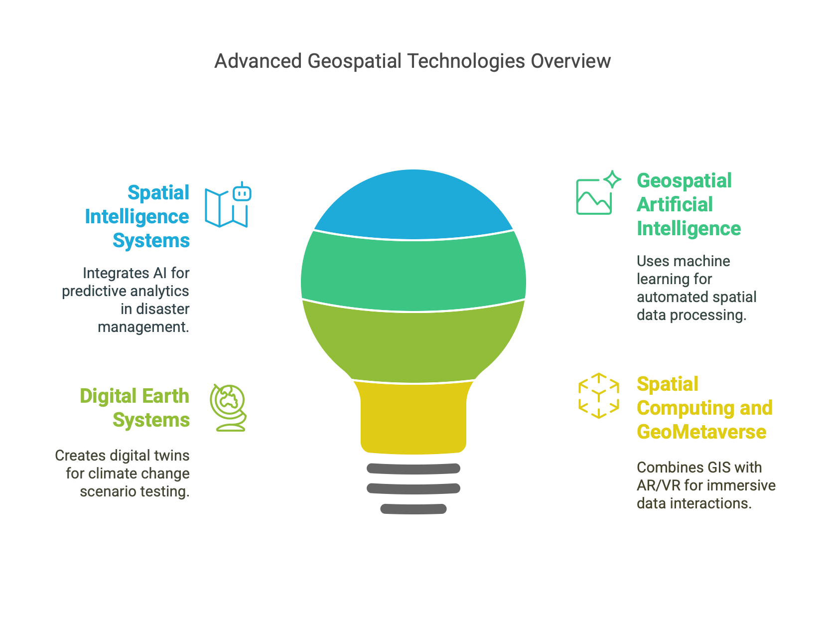
Spatial Intelligence Systems (SIS)
Spatial Intelligence Systems represent a sophisticated evolution of traditional GIS, integrating artificial intelligence, machine learning, and advanced predictive analytics to transform spatial decision-making processes. Unlike conventional GIS platforms that primarily focus on data visualization and basic analysis, SIS are designed to autonomously detect patterns, predict future scenarios, and generate actionable recommendations.
The Pacific Disaster Center’s DisasterAWARE platform exemplifies the potential of Spatial Intelligence Systems. By leveraging AI-powered spatial intelligence, the platform can predict typhoon paths in Southeast Asia with remarkable 72-hour forecasting accuracy. Independent studies have demonstrated that such advanced predictive capabilities can reduce potential casualties by up to 30% through more timely and precise evacuation strategies (Pacific Disaster Center Annual Report, 2022).
Geospatial Artificial Intelligence (GeoAI)
Geospatial Artificial Intelligence represents the convergence of traditional GIS methodologies with cutting-edge machine learning algorithms. GeoAI enables automated spatial data processing, anomaly detection, and predictive modeling that significantly surpass human analytical capabilities. By training algorithms on extensive geospatial datasets, researchers and organizations can develop systems that learn from historical spatial patterns and generate sophisticated insights.
Microsoft’s AI for Earth program provides a compelling illustration of GeoAI’s transformative potential. Their satellite imagery analysis algorithms can detect illegal deforestation activities in the Amazon rainforest with approximately 90% accuracy, enabling near-real-time environmental monitoring. Such capabilities represent a quantum leap from traditional manual satellite image interpretation methods, offering unprecedented scalability and precision in environmental conservation efforts (Microsoft Sustainability Report, 2023).
Digital Earth Systems (DES)
Digital Earth Systems represent an ambitious vision of creating comprehensive, real-time digital representations of our planet that integrate geospatial, environmental, and socio-economic data. Originally conceptualized by former U.S. Vice President Al Gore in 1998, this concept has evolved from a theoretical framework to an emerging technological reality with profound implications for global understanding and management.
The European Union’s Destination Earth (DestinE) initiative exemplifies the practical implementation of Digital Earth Systems. By creating high-resolution digital twins focused on climate change scenarios, DestinE enables policymakers to simulate and test potential adaptation strategies with unprecedented granularity. Their models operate at a 1-kilometer resolution, providing insights that were previously impossible to generate (European Commission Climate Action Report, 2023).
Spatial Computing and GeoMetaverse
Spatial computing represents a convergence of GIS, augmented reality, virtual reality, and Internet of Things technologies, enabling immersive interactions with geospatial data. The emerging concept of the GeoMetaverse extends this vision, proposing dynamic digital environments where users can explore, manipulate, and analyze spatial information in three-dimensional, interactive contexts.
Bentley Systems’ digital twin solutions demonstrate practical applications of spatial computing in infrastructure management. Their augmented reality platforms allow engineers to visualize underground utility networks on-site, reducing accidental utility strikes by approximately 35%. Such technologies not only improve operational efficiency but also significantly enhance workplace safety (Bentley Infrastructure Report, 2022).
Conclusion
The future of Geographic Information Systems is characterized by increasing intelligence, predictive capabilities, and seamless integration across technological domains. As artificial intelligence, machine learning, and immersive technologies continue to advance, geospatial systems will transition from passive data repositories to active, autonomous decision-support platforms.
For geospatial professionals, this technological evolution demands continuous learning and adaptability. The emerging landscape requires expertise that spans traditional GIS skills, advanced computational techniques, machine learning methodologies, and interdisciplinary systems thinking.
Organizations that successfully navigate this transformation will gain significant competitive advantages through enhanced predictive capabilities, operational efficiencies, and data-driven decision-making processes. The future of geospatial technology is not merely about mapping the world, but about developing sophisticated, intelligent systems that help us understand, predict, and proactively shape our global environment.
References
Tomlinson, R. F. (2007). “Thinking About GIS: Geographic Information System Planning for Managers”. ESRI Press.
Grand View Research. (2023). Geographic Information System (GIS) Market Size Report.
Pacific Disaster Center. (2022). Annual Technological Impact Report.
Microsoft Corporation. (2023). Sustainability and AI Research Report.
European Commission. (2023). Destination Earth Climate Action Report.
Bentley Systems. (2022). Global Infrastructure Technology Assessment.
Goodchild, M. F. (2018). “The Future of Spatial Analysis: Emerging Paradigms”. Annals of the Association of American Geographers, 108(3), 637-654.
