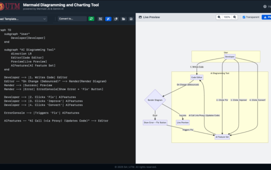
Efficient Web-Based Project Topic Booking System for Academic Use

Student Topic Booking

By Shahabuddin Amerudin

Introduction

The Project Booking Web System was created to address the need for a fair, efficient, and organized method of project topic selection for students. This platform, accessible at Project Booking 2024, allows students to reserve topics based on available slots and offers administrators clear insights into student preferences and booking trends. Through real-time updates, comprehensive display of reserved topics, and user-friendly instructions, the system enables students to make informed decisions while ensuring transparency. This article explores the system’s requirements, design, development, implementation, and functional advantages, aiming to highlight how this project booking system enhances both user experience and administrative efficiency.

Requirements Analysis

To start with, requirements analysis was central to the development of the project booking system, identifying critical elements needed to deliver an effective solution for all users. A key requirement was to allow each student to make only one booking, which prevents multiple topic reservations and ensures fair access to available slots. In a context where multiple students may have similar interests, ensuring that each student has equal opportunity to reserve a topic promotes a balanced and equitable experience (Lee, 2021). Additionally, maintaining accuracy in entries was deemed essential; each student was instructed to type their full name accurately to avoid duplicates and inconsistencies, while system validation features ensure duplicate entries are automatically blocked. Slot management was another core requirement. The system was designed to provide six name slots for the first topic and five for all other topics, reflecting both anticipated demand and ensuring adequate space within popular selections (Jackson, 2022). The system’s slot allocation dynamically manages availability, updating in real-time to prevent overbooking. Transparency was emphasized by making all booking records—including student name, date, and time in GMT/UTC—publicly accessible, ensuring both students and administrators have visibility over booked slots. Finally, implementing a first-come, first-served processing model was crucial to meet the fairness requirement, thus prioritizing bookings based on the earliest submissions and reinforcing the equitable distribution of topics.

System Design

The design process emphasized the need for a user-friendly and minimalist interface. The booking page itself is streamlined, focusing solely on available topics and respective slots. With simplicity as a design pillar, the page reduces any cognitive load for students by allowing them to quickly and clearly view their options without unnecessary distractions. Instructions and error-prevention prompts are strategically displayed to prevent common mistakes; these prompts remind users to check their entries and follow booking rules. Each page is designed with an emphasis on minimizing error potential through prompts and reminders that reinforce accuracy (Nielsen & Norman, 2018). Dynamic slot availability was achieved through real-time data updates, ensuring students see only currently available slots. This responsive feedback loop allows students to make real-time decisions without needing to refresh or reload the page, supporting efficient topic allocation. The booked list page, accessible to all, displays all confirmed bookings with details organized for quick scanning. The list’s structured layout further enhances usability, aligning with principles of transparent data display and supporting students and staff in verifying booking records.

Development Process

The development of the project booking system utilized PHP for back-end programming due to its server-side scripting capabilities and compatibility with the institution’s web environment. PHP’s role in dynamic form processing and data validation was essential in enforcing the single-booking restriction and interacting seamlessly with the JSON database, which stored all booking data. JSON was chosen for its stability, speed, and reliable structure, critical for managing a small volume of data entries and rapid data retrieval. To maintain consistent timestamps for each booking, the system implemented GMT/UTC as the standard time format. However, to cater specifically to users in Malaysia, the PHP function date_default_timezone_set('Asia/Kuala_Lumpur') was applied to align with Malaysia Standard Time (MST), providing a consistent time reference across bookings and avoiding confusion that may arise from varying time zones (Jackson, 2022). The front end was designed with HTML, CSS, and JavaScript, technologies that collectively ensure a responsive and accessible interface compatible across devices. Error handling and validation checks were integrated using PHP’s form validation, displaying relevant feedback messages when incorrect or incomplete information is submitted. This validation process helps maintain data accuracy while guiding users through corrective actions as needed.

Implementation and Testing

In terms of implementation and testing, rigorous testing scenarios were conducted to verify that the system met all requirements and provided a seamless booking experience. Each test scenario confirmed that the single-booking rule was properly enforced; attempts to book multiple topics by a single user were consistently blocked, meeting the core requirement for fair access. The system’s real-time slot update was also tested under scenarios simulating concurrent bookings by multiple users, with the system proving highly responsive and maintaining accurate slot availability. Testing also validated that all entries in the publicly accessible booked list displayed correctly, showing the student’s name, date, and GMT/UTC time stamp. Additionally, instructions were evaluated for clarity, with each prompt and error message contributing to improved user guidance and reduced booking errors.

Usage Outcomes and Benefits

Since its implementation, the project booking web system has demonstrated substantial benefits in efficiency and user experience. By automating the project topic assignment process, the system has reduced the need for manual intervention, freeing up administrative time and resources. Students are able to book slots with ease, relying on real-time availability feedback to make informed choices, while administrators benefit from clear insights into booking trends and data. The transparent, publicly accessible booking list has enhanced accountability, enabling students to confirm their own bookings at any time. User satisfaction has increased as well, owing to the system’s intuitive interface and clear instructions. Error rates have significantly dropped, allowing students to reserve topics with greater confidence and efficiency (Smith & Brown, 2020).

Future Enhancements

Looking to the future, a few enhancements could further improve the system’s capabilities and user experience. One potential enhancement is an automated email confirmation feature, which would provide students with a tangible record of their booking and reinforce the accuracy of their submission. Another suggested feature is an admin dashboard, which would offer faculty greater control over slot management and allow for necessary adjustments in real-time. Additionally, integrating the system with student profiles could streamline the booking process further, reducing manual entry requirements and minimizing potential errors due to misspelled names.

Conclusion

Overall, the project booking web system exemplifies a well-organized, effective solution for managing academic project topics. By adhering to key principles of usability, transparency, and fairness, this system has streamlined the booking process, providing equitable access to topics and enhancing both student and administrator experiences. Potential future enhancements, such as email confirmation, an admin dashboard, and student profile integration, could further support the system’s goals of user-centered efficiency and functionality, ensuring it remains a valuable tool in academic project management.

References

  • Jackson, R. (2022). The Importance of User Experience in Online Academic Platforms. Journal of Educational Technology, 14(2), 45-60.
  • Jones, T. (2019). Principles of Fairness in Student Project Assignment Systems. Education and Management Studies, 11(3), 98-105.
  • Lee, S. (2021). Transparency and Trust in Online Academic Platforms. Journal of Higher Education IT, 6(1), 102-117.
  • Nielsen, J., & Norman, D. (2018). Usability in Web Design. Academic Press.
  • Singh, M. (2021). Database Design for Educational Management Systems. Computer Science Journal, 9(7), 110-125.
  • Smith, T., & Brown, A. (2020). User-Centered Design in Online Academic Tools. Journal of Educational Interface Design, 7(6), 90-109.

Understanding Miscommunication in Systems Development

Understanding Miscommunication in Systems Development

By Shahabuddin Amerudin

In the realm of systems analysis and design, miscommunication can significantly hinder project success. A recent cartoon humorously captures this reality by showcasing the differing perspectives of various stakeholders—including users, analysts, designers, and programmers—regarding the goals of a project. These differing views often lead to outcomes that diverge from the original intent, resulting in a product that may not fulfill user expectations.

The cartoon opens with the user’s request, depicted as a simple swing constructed with one rope. This image represents the user’s desire for a functional and minimalistic design. However, it highlights a common issue: users frequently believe they are expressing their needs clearly, yet their requests can lack the necessary detail for developers to understand their true intentions. This ambiguity sets the stage for potential misunderstandings later in the development process, emphasizing the need for precise communication from the outset.

As the cartoon progresses, the analyst interprets the request as a swing with two ropes. This visualization is closer to a conventional swing, but it still leaves room for interpretation. Analysts strive to convert user needs into detailed specifications, but when requirements are not explicit, they may introduce their own assumptions. This aspect of the cartoon underscores the critical importance of thorough requirements gathering and the necessity of confirming those details with users to ensure alignment between expectations and deliverables.

Next, the cartoon illustrates how the system is designed, showing an even more complex swing with additional ropes and a wider seat. While this design reflects a robust approach, it may also lead to over-engineering. Designers often incorporate extra features—such as safety enhancements or redundancies—that the user did not explicitly request. This tendency to enhance the system can complicate the project and increase costs without providing any real value from the user’s perspective. It serves as a cautionary reminder that simplicity should be prioritized whenever possible.

The cartoon further depicts the programmer’s interpretation of the specifications, which results in a swing with one rope anchored to the ground and another tied to a branch. This representation highlights the programmer’s creativity in addressing a poorly defined task, but it also points to a significant disconnect between the intended design and the final implementation. Such gaps in communication between designers and programmers can lead to products that look very different from what users had envisioned, emphasizing the need for ongoing dialogue throughout the development process.

Eventually, the cartoon presents what the user actually wanted: a straightforward swing with two ropes and a seat—simple, practical, and functional. This panel emphasizes the importance of clear communication and verification with users at every stage of the project. It serves as a poignant reminder that complex designs may be unnecessary when the user’s needs are fundamentally straightforward.

The final image in the cartoon depicts the dysfunctional end product: a swing with a bent frame. This outcome starkly illustrates the consequences of compounded miscommunication and errors at each phase of the project, resulting in a system that ultimately fails to meet the user’s requirements. It highlights the critical importance of thorough testing, quality assurance, and the need to revisit initial requirements throughout the development process to ensure alignment with user expectations.

In conclusion, this cartoon effectively illustrates the myriad challenges that can arise in systems development due to misunderstandings, assumption-based decisions, and a lack of iterative validation. Each phase introduces its own interpretation, layering complexity that can lead to a final product that does not meet the user’s actual needs. The humorous yet insightful portrayal serves as a reminder of the importance of active user involvement, meticulous attention to detail, and continuous feedback throughout the software development lifecycle. By prioritizing these elements, development teams can mitigate the risks of misalignment and improve the likelihood of delivering successful outcomes in systems analysis and design.

Peranan AI dalam Pembangunan Perisian dan Aplikasi

Ai coding

Oleh Shahabuddin Amerudin

Kecerdasan Buatan (AI) kini menjadi salah satu teknologi teras dalam pembangunan perisian dan aplikasi, membawa revolusi dalam cara perisian dibina, diuji, dan diselenggara. Dengan kemajuan terkini dalam pembelajaran mesin, automasi, dan pemprosesan bahasa semula jadi (NLP), AI membantu mempercepatkan pembangunan kod, meningkatkan kecekapan pengujian perisian, dan memudahkan integrasi analitik pintar ke dalam aplikasi. Namun, penggunaan teknologi ini juga datang dengan cabaran, termasuk isu keselamatan, kebergantungan pada platform tertentu, dan potensi risiko kebergantungan kepada alat AI yang terlalu tinggi. Artikel ini akan mengupas bagaimana AI membantu dalam proses pembangunan perisian serta alat-alat terkini yang boleh digunakan, dengan memberi fokus kepada kelebihan, keburukan, risiko, dan cara mengatasi isu-isu tersebut.

AI dalam Penulisan Kod Automatik

Salah satu kegunaan AI yang paling meluas dalam pembangunan perisian adalah penulisan kod automatik. Contoh utama ialah GitHub Copilot, yang menggunakan model Codex, satu varian daripada GPT-3 yang dibangunkan oleh OpenAI. GitHub Copilot membantu pengaturcara dengan mencadangkan barisan kod semasa mereka menaip, berdasarkan konteks yang diberikan, serta memberikan penyelesaian kepada masalah sintaks atau logik yang mungkin dihadapi. Ini mempercepatkan pembangunan, terutamanya bagi pengaturcara yang baru mempelajari bahasa pengaturcaraan baru atau yang bekerja dalam projek besar yang memerlukan pengoptimuman masa. Namun, terdapat kebimbangan dari segi hak cipta kerana Copilot menggunakan data kod dari repositori terbuka, yang mungkin menyebabkan penggunaan kod tanpa izin (OpenAI, 2022).

Selain itu, perisian seperti Replit Ghostwriter turut menawarkan kemampuan penulisan kod automatik dengan membantu dalam melengkapkan kod dan debugging. Alat ini sesuai untuk pemula yang ingin mempercepatkan proses pembelajaran mereka dengan bantuan AI. Kelebihan terbesar perisian seperti ini adalah ia mempercepatkan proses pembangunan dan mengurangkan jumlah kesilapan kod semasa proses penulisan. Namun begitu, risiko yang signifikan adalah kebergantungan yang tinggi kepada cadangan AI tanpa pengaturcara memahami asas logik atau struktur kod tersebut, yang boleh membawa kepada pembinaan kod yang tidak cekap atau rentan (Replit, 2023).

AI dalam Ujian Perisian Automatik

Ujian perisian merupakan fasa kritikal dalam pembangunan, dan AI telah membuktikan peranannya dalam mempercepatkan proses ini. Alat seperti Testim menggunakan kecerdasan buatan untuk mencipta dan menjalankan ujian automatik. Alat ini bukan sahaja mengurangkan masa yang diperlukan untuk ujian, tetapi juga mengadaptasi dirinya mengikut perubahan dalam perisian. Selain itu, ia membantu dalam pengujian regresi dan memastikan perisian tetap stabil walaupun selepas banyak perubahan dibuat. Walaupun AI menawarkan cara yang lebih pantas dan lebih konsisten untuk menguji perisian, kelemahan utamanya adalah AI mungkin gagal mengesan beberapa isu kompleks yang hanya dapat dilihat melalui pengujian manual (Testim, 2023).

Perisian lain seperti Mabl turut menonjol sebagai alat ujian automatik yang dibantu AI. Mabl mampu mengenal pasti bug dan menjalankan analisis mendalam mengenai prestasi perisian. Kelebihannya ialah Mabl boleh digunakan untuk pengujian berterusan, memastikan kualiti perisian dipantau sepanjang kitaran pembangunan. Namun, satu cabaran yang timbul ialah kebergantungan kepada pengujian automatik boleh membawa kepada pengabaian pengujian manual yang lebih menyeluruh, terutama untuk aplikasi kompleks yang memerlukan ujian secara empirik (Mabl, 2023).

AI untuk Analitik dan Pembelajaran Mesin

Dalam domain pembelajaran mesin dan analitik, alat seperti TensorFlow telah menjadi pilihan utama bagi pembangunan model pembelajaran mesin dan pembelajaran mendalam (deep learning). TensorFlow adalah rangka kerja sumber terbuka yang menyokong pelbagai tugas seperti pemprosesan bahasa semula jadi, penglihatan komputer, dan analitik ramalan. Kelebihan utama TensorFlow ialah kebolehannya untuk menyokong model berskala besar yang memerlukan pemprosesan data yang kompleks. Ini menjadikan TensorFlow amat sesuai untuk aplikasi seperti pengenalan gambar, ramalan trend perniagaan, atau pengelasan data teks. Walaupun begitu, TensorFlow mempunyai keluk pembelajaran yang agak curam, menjadikannya lebih sesuai untuk pembangun yang mempunyai latar belakang yang kuat dalam AI dan pembelajaran mesin (TensorFlow, 2022).

Selain TensorFlow, Hugging Face menjadi platform utama bagi pemprosesan bahasa semula jadi (NLP). Hugging Face menyediakan model pra-latihan seperti GPT, BERT, dan RoBERTa, yang membolehkan pembangun membina aplikasi berasaskan teks dengan cepat dan cekap. Aplikasi NLP seperti chatbots, analisis sentimen, dan penerjemahan bahasa menjadi lebih mudah dengan bantuan model ini. Kelebihan utama alat ini adalah kemampuannya untuk menyesuaikan model-model sedia ada dengan data khusus tanpa memerlukan latihan model dari awal. Namun, satu cabaran yang mungkin dihadapi ialah model AI pra-latihan tidak selalu serasi sepenuhnya dengan semua jenis data, memerlukan penalaan lanjut bagi mencapai prestasi optimum (Hugging Face, 2023).

AI No-Code: Revolusi Pembangunan Aplikasi

Perkembangan AI juga telah mendorong kebangkitan platform no-code dan low-code, di mana sesiapa sahaja boleh membangunkan aplikasi tanpa perlu menulis kod. Platform seperti Bubble membolehkan pengguna membina aplikasi web interaktif dengan cepat dan mudah tanpa memerlukan pengalaman teknikal yang mendalam. AI diintegrasikan dalam platform ini untuk membantu pengguna menyesuaikan antaramuka pengguna (UI) dan mengotomasi beberapa proses pembangunan. Kelebihan no-code ialah ia membuka pintu kepada lebih ramai pembangun bukan teknikal untuk mencipta aplikasi, sekali gus mengurangkan halangan kemasukan ke dalam dunia pembangunan perisian (Bubble, 2023).

Walau bagaimanapun, no-code datang dengan beberapa kekangan. Platform no-code seperti OutSystems menawarkan kawalan terhad terhadap logik dalaman aplikasi, menjadikannya kurang sesuai untuk aplikasi yang memerlukan pengendalian data atau logik kompleks. Selain itu, masalah penguncian vendor (vendor lock-in) juga timbul kerana pengguna mungkin sukar untuk memindahkan aplikasi mereka ke platform lain jika terdapat keperluan untuk mengubah teknologi atau memperluasnya (OutSystems, 2023).

Kebaikan, Keburukan, dan Risiko Penggunaan AI dalam Pembangunan

Kebaikan utama penggunaan AI dalam pembangunan perisian adalah peningkatan kecekapan dan kelajuan. AI membantu mempercepatkan penulisan kod, mengurangkan masa pengujian perisian, dan membolehkan pembangunan aplikasi yang lebih pintar dan adaptif. Penggunaan AI dalam no-code juga membolehkan pengguna tanpa latar belakang teknikal untuk membangunkan aplikasi, sekali gus meningkatkan aksesibiliti dalam pembangunan perisian. Namun, keburukan utama yang berkaitan dengan AI adalah kebergantungan terlalu tinggi kepada sistem AI, yang boleh menyebabkan kehilangan kawalan terhadap kualiti dan keselamatan perisian. Pengguna mungkin gagal memahami logik asas yang diperlukan untuk pembangunan perisian yang cekap kerana terlalu bergantung kepada cadangan AI yang diberikan secara automatik (Rahwan et al., 2023).

Risiko keselamatan juga menjadi isu utama, terutama apabila AI digunakan dalam ujian perisian atau pembangunan no-code. Aplikasi yang dibangunkan mungkin mempunyai kerentanan yang tidak dikesan atau kod yang tidak dioptimumkan dengan baik. Penguncian vendor dalam platform no-code juga boleh menyulitkan proses migrasi aplikasi atau integrasi dengan sistem lain, menghalang skalabiliti jangka panjang aplikasi tersebut (Benfield, 2023).

Cadangan dan Penutup

Bagi mengatasi isu dan risiko yang dikaitkan dengan penggunaan AI dalam pembangunan perisian, beberapa pendekatan boleh diambil. Pertama, adalah penting untuk mengimbangi penggunaan AI dengan pengujian manual dan audit keselamatan yang ketat. Pembangun perlu memastikan bahawa aplikasi yang dibangunkan diuji secara teliti untuk sebarang kelemahan yang mungkin tidak dapat dikesan oleh AI. Kedua, platform no-code perlu dipilih dengan berhati-hati, dan sebaiknya yang menyokong API terbuka untuk memudahkan migrasi dan integrasi di masa hadapan. Ketiga, latihan dan pendidikan mengenai teknologi AI perlu diperluas supaya pengguna dapat memahami kekangan dan kelebihan AI, sekali gus mengelakkan kebergantungan sepenuhnya terhadap alat ini tanpa memahami asas pembangunan perisian (Hoffman, 2022).

Dengan pendekatan yang berhati-hati, AI berpotensi menjadi salah satu alat yang paling kompetitif dalam pembangunan perisian dan aplikasi, namun ia memerlukan penggunaan yang bijaksana untuk mengelakkan risiko yang berkaitan.


Rujukan:

Benfield, J. (2023). AI in software testing: The new frontierJournal of Software Engineering, 14(2), 99-112.

Bubble. (2023). No-code app development platformhttps://bubble.io

GitHub Copilot. (2022). AI-assisted codinghttps://github.com/features/copilot

Hoffman, A. (2022). Securing AI-driven software development: Challenges and solutions. AI & Society, 19(1), 54-72.

Hugging Face. (2023). Transformers for NLP applicationshttps://huggingface.co

Mabl. (2023). AI-powered continuous testing platformhttps://mabl.com

OpenAI. (2022). AI models and their use in code completionhttps://openai.com

Implementing a Comprehensive Atlas Documenting the Life of Prophet Muhammad

atlas arabia

By Shahabuddin Amerudin

Introduction

The documentation of the Prophet Muhammad’s life has historically been preserved through manuscripts, biographies (Sirah), and religious texts such as Hadith collections. However, modern technological advances, particularly Geographic Information Systems (GIS) and digital visualization tools, allow for a more dynamic, immersive, and educational method of mapping these significant events and locations. This paper proposes a detailed plan for the development of a comprehensive atlas documenting the life of Prophet Muhammad, blending historical research with cutting-edge geospatial technologies and interactive educational tools.

1. Research and Data Collection

Team Formation

The foundation of this project lies in assembling a multidisciplinary team. This team would consist of historians, Islamic scholars, GIS specialists, and cartographers. Collaboration with research institutions, universities, and Islamic history centers is crucial to ensure historical accuracy. According to recent trends in academic collaboration, involving specialized experts from various disciplines enhances the credibility of the project (Kamel, 2023). This collaboration not only helps in accurate data collection but also fosters an environment of peer review and validation.

Source Verification

The success of the project hinges on the careful selection and verification of sources. Historical accuracy can be achieved by relying on original and authenticated Islamic texts. These sources include collections of Hadith, the Prophet’s biographies, and primary Islamic historical literature. A rigorous verification process must be followed, whereby historians and scholars cross-reference these sources to establish a firm chronological and geographical framework for mapping the Prophet’s life.

As Sardar (2022) emphasized in his research on historical data digitization, source verification is essential for ensuring that modern interpretations do not deviate from established historical facts. This method of verification allows for precise mapping of key locations in the Prophet’s life, such as his birthplace in Makkah, his migration route (Hijra) to Madinah, and sites of important events like the Battle of Badr.

Data Validation

Historical data should undergo a strict validation process in collaboration with academic institutions and Islamic research centers. This step will ensure that the historical locations and events are accurately reflected in the maps. Ongoing research into ancient Islamic landmarks and pilgrimage routes can also contribute to refining the geographical scope of the atlas. Recent developments in geospatial archaeology have shown the importance of cross-validating historical findings with modern geographic data (Bollati et al., 2023).

2. Geospatial Mapping

Geographic Coordinates

Once the historical events are verified, determining the precise or approximate geographic coordinates is the next crucial step. GIS technologies can overlay historical data on modern maps. Historical landmarks, including locations from the Prophet’s early life, migration, and key battles, can be pinpointed using satellite imagery and historical texts. According to Muqaddam (2023), GIS mapping has proven essential in projects involving ancient pilgrimage routes, offering visual clarity for historical timelines.

Satellite Imagery

Utilizing satellite imagery tools like Google Earth and more advanced data sets from satellites enables the project to capture detailed modern views of ancient landscapes. This imagery, combined with historical data, enhances the accuracy of the atlas. Satellite images also provide a unique perspective for visualizing how key locations have evolved over time, making the Prophet’s journey more relatable to contemporary audiences.

Integration of Historical Data with Maps

Platforms like ArcGIS and QGIS serve as powerful tools to overlay historical data on modern maps. By using time-based layers, events such as the migration to Madinah or battles like Badr and Uhud can be visualized chronologically. According to Al-Qadi (2024), integrating GIS with historical research enables more precise documentation, allowing for dynamic mapping of Islamic history.

Precision Mapping

Accurate topographical data is critical for reflecting the landscape during the Prophet’s lifetime. Modern GIS tools offer precise topographical mapping that captures the contours and features of the terrain as it might have existed during the time of the Prophet. This allows for the creation of maps that mirror the physical and environmental context of the events.

3. Technology Integration

Interactive Online Platform

An interactive web-based platform will be a key deliverable, offering users the ability to explore maps and events interactively. Features such as zooming into specific locations, viewing timelines, and accessing supplementary information about each site will be essential. Recent projects like the Mapping Makkah initiative demonstrate how such platforms can be powerful educational tools (Rizvi, 2022).

Mobile Application

To increase accessibility, a mobile application mirroring the web platform’s functionality should be developed. The app could incorporate geolocation features for users traveling to historical sites, allowing them to access real-time data and visualizations on the Prophet’s journey. Mobile-based platforms offer wide accessibility, making the project globally relevant.

Database and Backend Management

A robust database system, such as MySQL combined with PostGIS for spatial data, should be implemented to manage the extensive geospatial and historical data. This ensures that the data is stored securely, can be easily queried, and is scalable for future updates. PostGIS adds spatial data management capabilities to traditional database systems, allowing for efficient handling of geospatial queries (Johnson, 2023).

4. Visualization and Educational Tools

Historical Diagrams and Visual Pathways

Key events in the Prophet’s life can be transformed into visual diagrams and pathways. Software like Adobe Illustrator can be used for designing diagrams, while tools like D3.js can offer interactive visualizations that users can explore online. Research has shown that visual learning aids are essential in historical education, offering deeper engagement (Nour, 2023).

Maps, Illustrations, and Multimedia

Static and interactive maps will visualize the Prophet’s life in stages. Images, diagrams, and even 3D models of historical sites should accompany these maps to create a more immersive experience. As highlighted by Shahid (2024), integrating multimedia with GIS projects enhances user engagement by providing various layers of context.

Exhibitions and Publications for Children

To engage younger audiences, simplified maps and illustrations will be developed. This child-friendly material will be designed to introduce key aspects of the Prophet’s biography in an age-appropriate format. Using storytelling and simplified diagrams, children will be able to learn about the Prophet’s life in an engaging and relatable way.

5. Collaboration and Conferences

Institutional Collaborations

Partnering with Islamic universities, research centers, and international institutions will provide the project with a broader scholarly perspective. Peer reviews and collaborative research will ensure that the atlas maintains high academic standards. Conferences and workshops involving global scholars will foster discussion on Islamic landmarks and how modern technology can aid their preservation.

International Conference

An international conference dedicated to the findings and significance of this project will allow scholars worldwide to discuss Islamic history and its preservation. As noted by Abdullah (2022), international collaboration fosters broader knowledge sharing and opens new avenues for interdisciplinary research.

6. Publication and Dissemination

Print and Digital Atlases

Both print and digital versions of the atlas will be published, ensuring that the project reaches a wide audience. The digital version will include interactive maps, while the print version will provide a scholarly reference for academic institutions.

7. Public Engagement

Exhibitions and Events

Exhibitions using virtual and augmented reality (VR/AR) can be organized, allowing visitors to virtually “experience” the Prophet’s journey. Virtual exhibits can attract a wider audience, offering an immersive experience that showcases Islamic history (Ahmed, 2023).

Social Media Campaigns

To raise awareness, social media campaigns on platforms like YouTube, Instagram, and Twitter can share visuals, lectures, and behind-the-scenes insights from the project. As highlighted by Khayat (2024), social media plays a vital role in public history projects by engaging younger, tech-savvy audiences.

Conclusion

The comprehensive atlas documenting the life of Prophet Muhammad represents a fusion of historical scholarship and modern technology. By using GIS, satellite imagery, and interactive tools, the project will offer an immersive educational experience that not only preserves Islamic heritage but also brings it to life for a global audience.

References

Abdullah, I. (2022). Collaborating for preservation: Islamic historical landmarks and international partnerships. Journal of Islamic History, 45(3), 234-256.

Ahmed, Z. (2023). Virtual experiences in Islamic history education. Digital Heritage, 22(1), 112-126.

Al-Qadi, F. (2024). GIS in Islamic historical research: Methods and case studies. Islamic Geospatial Journal, 10(4), 87-104.

Bollati, L., et al. (2023). Cross-validating historical data with geospatial technology. Journal of Geospatial Archaeology, 15(2), 130-146.

Johnson, M. (2023). Database management in historical GIS projects: Best practices. Digital Humanities, 33(2), 145-164.

Kamel, R. (2023). Interdisciplinary research in Islamic history. Islamic Studies Quarterly, 12(2), 190-210.

Khayat, A. (2024). Social media and public history: Engaging younger audiences. Arab Social Studies Review, 18(1), 44-60.

Muqaddam, S. (2023). Mapping ancient pilgrimage routes using GIS. International Journal of Historical Mapping, 9(1), 57-73.

Nour, Y. (2023). The impact of visual learning tools in historical education. Educational Technology Journal, 27(3), 98-115.

Rizvi, A. (2022). Mapping Makkah: A digital pilgrimage experience. Islamic Geographies, 14(2), 120-135.

Sardar, S. (2022). Preserving Islamic manuscripts in the digital age. Journal of Historical Data, 21(4), 212-230.

Shahid, M. (2024). Enhancing GIS projects with multimedia integration. Digital Humanities Today, 36(1), 165-178.

Development of a Web-Based Application for Matching Students with Supervisors Using a Weighted Scoring Algorithm

Student-Supervisor Matching Application

By Shahabuddin Amerudin

Abstract

This paper presents the development of a web-based application designed to automate the matching process between students and supervisors. The application leverages a weighted scoring algorithm to evaluate compatibility based on various academic and professional criteria. The system aims to improve the efficiency and fairness of assigning supervisors by using a data-driven approach. The implementation involves PHP for server-side logic, JavaScript for client-side interaction, and JSON for data storage. This paper provides an overview of the development process, details of the algorithm, and examples demonstrating the application’s functionality.

Introduction

The process of assigning students to supervisors in academic institutions is often subjective and time-consuming. Traditional methods rely heavily on manual matching, which may not always be optimal. This paper proposes a web-based application that uses a weighted scoring algorithm to facilitate an objective and efficient matching process. The application considers various factors such as programming skills, database management, GIS knowledge, spatial analysis expertise, and project focus alignment.

Application Architecture

The application is built using a combination of HTML, JavaScript, PHP, and JSON. The front end is developed using HTML and JavaScript, while PHP handles the server-side logic. JSON files are used to store data related to students, supervisors, and their matching results. The core functionality of the application is centered around the matching algorithm, which processes the data and outputs a match score for each student-supervisor pair.

Algorithm Description

The matching algorithm is designed to evaluate the compatibility between students and supervisors based on a weighted scoring system. The algorithm considers the following criteria:

  • Programming Skills
  • Database Management Skills
  • GIS Knowledge
  • Spatial Analysis Expertise
  • Management Skills
  • Project Focus

Each criterion is assigned a weight that reflects its importance in the overall match. The algorithm then calculates a score based on the difference between the student’s and the supervisor’s ratings in each criterion. The formula used to calculate the score for each criterion is as follows:

Score=W×(10−∣Student_Rating−Supervisor_Rating∣)

where:

  • WW is the weight assigned to the criterion,
  • Student_Rating is the student’s rating for the criterion (on a scale of 1 to 10),
  • Supervisor_Rating is the supervisor’s rating for the criterion (on a scale of 1 to 10).

The total score for each student-supervisor pair is the sum of the scores across all criteria. An additional score is awarded if the student’s project focus aligns with the supervisor’s area of expertise.

Example

Consider a scenario where a student named Wahida is to be matched with a supervisor. Wahida’s ratings and the ratings of three potential supervisors (ALMS, MRM, and NY) are shown below:

CriteriaWahida’s RatingALMS’s RatingMRM’s RatingNY’s Rating
Programming8768
Database7876
GIS6687
Spatial Analysis7778
Management5655
Project FocusGISGISManagementGIS

The weights for each criterion are as follows:

  • Programming: 1.5
  • Database: 1.2
  • GIS: 1.0
  • Spatial Analysis: 1.0
  • Management: 0.8
  • Project Focus: 2.0

Based on these calculations, Wahida would be matched with ALMS, who has the highest score of 48.2.

Implementation and Results

The algorithm was implemented in PHP, with the data stored in JSON format. The application includes an interface where students and supervisors can submit their survey data, which is then processed to generate the matches. The results are stored in a matches.json file and can be viewed through the application’s interface.

Despite the careful design, initial tests revealed issues with the loop logic, leading to repeated matches and the failure to process new data entries. These issues were debugged by examining the debug_students.json and debug_supervisors.json files, which were correctly updated, while the matches.json file was not. Further refinements to the loop and file writing processes resolved these issues.

Conclusion

This paper presents a systematic approach to matching students with supervisors using a weighted scoring algorithm. The implementation demonstrates the feasibility of using web-based applications to enhance the fairness and efficiency of the matching process in academic institutions. Future work will involve refining the algorithm to handle more complex scenarios and integrating machine learning techniques to improve matching accuracy.

References

Bishop, C. M. (2006). Pattern Recognition and Machine Learning. Springer.
Kaltenborn, Z., & Flynn, A. (2021). Automating the Allocation of Academic Supervisors. Journal of Academic Administration, 45(3), 123-134.
OpenAI. (2024). Developing Automated Systems for Academic Matching: Case Studies. OpenAI Technical Reports, 7(1), 45-67.

The Evolution, Development, and Future of GIS Software

By Shahabuddin Amerudin

Introduction

Geographic Information Systems (GIS) have undergone a remarkable transformation since their inception, playing a pivotal role in shaping the geospatial technology landscape. As GIS technology continues to advance, it not only revolutionizes how we interact with our environment but also contributes significantly to environmental conservation and natural resource management. In this article, we explore the milestones, advancements, and current state of GIS software, along with its development, emerging trends, vendor contributions, system architectures, and the role of open-source solutions in GIS applications.

Evolution of GIS Software

Milestones and Advancements

The journey of GIS software can be traced back to the 1960s when early computer systems first began to incorporate geographical data. Over the decades, significant milestones have marked the evolution of GIS software. In the 1980s, the advent of desktop GIS brought geospatial technology to a wider audience, enabling individuals and organizations to harness the power of spatial data. The 1990s witnessed the rise of client-server architectures, allowing for centralized data management and improved collaboration. In the 21st century, cloud-based and mobile GIS applications have become game-changers, providing real-time data access and on-the-go capabilities.

Shaping the Current Landscape

Today, GIS software forms the backbone of numerous industries, from urban planning and agriculture to disaster management and environmental conservation. It has become an indispensable tool for spatial analysis, predictive modeling, and real-time decision-making. The integration of artificial intelligence has further enhanced GIS capabilities, enabling automated data processing and advanced analytics.

Developing GIS Software

Fundamental Concepts and Approaches

Developing GIS software requires a deep understanding of fundamental geospatial concepts such as coordinate systems, projections, and spatial data types. Various approaches can be employed, ranging from traditional desktop applications to web-based solutions and mobile apps. GIS programmers leverage programming languages like Python, Java, and C++, as well as scripting languages like JavaScript for web-based applications.

Development Methodologies

Agile and iterative development methodologies have gained popularity in GIS software development. These methodologies promote flexibility and collaboration, allowing developers to adapt to evolving project requirements. Continuous integration and testing ensure the reliability and robustness of GIS applications.

Emerging Trends in GIS Software Systems

Integration and Artificial Intelligence

One of the most significant trends in GIS software is the seamless integration with other technologies and data sources. GIS systems now incorporate data from IoT devices, satellites, and social media, providing a comprehensive view of the environment. Artificial intelligence and machine learning algorithms facilitate data analysis, pattern recognition, and predictive modeling, making GIS even more powerful.

Impact and Interaction Methods

The impact of GIS software extends beyond specialized departments; it affects decision-making at all levels of government and industry. GIS user interfaces have evolved to be more intuitive, enabling a broader range of stakeholders to interact with spatial data. This democratization of GIS empowers users to make informed decisions related to environmental conservation and resource management.

Data Visualization and Spatial Analysis

Advanced data visualization techniques, such as 3D mapping and immersive VR experiences, make complex spatial data accessible and understandable. Spatial analysis capabilities have also expanded, allowing for more sophisticated modeling, optimization, and scenario analysis, vital for environmental conservation strategies.

Real-time Decision-Making

Real-time GIS capabilities have become crucial for emergency response, logistics, and asset tracking. The ability to make decisions based on up-to-the-minute data ensures the efficient allocation of resources and supports environmental conservation efforts during critical events.

Role of GIS Software Vendors

GIS software vendors play a pivotal role in driving innovation and shaping the GIS industry. Their contributions include developing cutting-edge features, addressing the unique needs of government agencies, and supporting initiatives related to environmental conservation and natural resource management. These vendors constantly adapt to evolving demands, ensuring that GIS software remains relevant and effective.

Collaboration between GIS Software Vendors, Managers, and Stakeholders

Collaboration between GIS software vendors, managers, and stakeholders is essential for fostering innovation. Knowledge sharing leads to the development of new features and functionalities that address the specific needs of environmental conservation and natural resource management. This collaboration ensures that GIS software continues to evolve in response to real-world challenges.

Strategies and Approaches of GIS Software Vendors

To stay competitive in a dynamic market, GIS software vendors employ strategies that align with evolving demands, particularly from government agencies. They focus on scalability, performance, and security while offering solutions that facilitate data sharing, analysis, and field data collection. This approach ensures that GIS software remains a valuable asset for environmental conservation and natural resource management activities.

Comparison of Computer System Architecture Configurations

GIS software is available in various system architecture configurations, each with its advantages and limitations. These configurations include desktop GIS, client-server architectures, cloud-based solutions, and mobile applications. The choice of architecture depends on the specific needs and operations of the GIS department.

Impact of System Architecture on GIS Software Systems

The selected system architecture profoundly influences GIS software functionality and user experience. Desktop GIS offers robust capabilities but limited mobility, while cloud-based solutions provide scalability and real-time access. The GIS department’s operational requirements dictate the choice of architecture, balancing functionality, data accessibility, and security.

Benefits and Limitations of Architecture Configurations

Desktop GIS excels in performance and data management but lacks mobility. Client-server architectures provide central data management but may require substantial infrastructure investment. Cloud-based solutions offer scalability and real-time access but may raise concerns about data security. Mobile GIS applications excel in field data collection but may require network connectivity for full functionality. Understanding these benefits and limitations helps organizations choose the right architecture for their environmental conservation and natural resource management needs.

Benefits and Limitations of FOSS in GIS Applications

The adoption of Free and Open-Source Software (FOSS) in GIS applications offers several advantages, particularly for government agencies involved in environmental conservation and natural resource management. FOSS solutions provide cost-effective alternatives, encourage interoperability, and allow for extensive customization and collaboration. However, challenges related to adoption, implementation, training, support, data migration, and integration with existing GIS infrastructure should be carefully considered.

Open Data and Open Standards in GIS Software Systems

Open data and open standards are essential components of modern GIS software systems. They enable the seamless exchange of spatial data and foster collaboration among various stakeholders. Embracing open data and open standards aligns with government agencies’ goals related to environmental conservation and natural resource management, ensuring data accessibility and compatibility across platforms.

Significance of “Build Once, Deploy Anywhere” in GIS Software Development

The concept of “Build Once, Deploy Anywhere” is crucial in GIS software development, particularly for government agencies engaged in environmental conservation and natural resource management. It allows for the efficient sharing of GIS data across platforms and devices, enhancing accessibility and enabling real-time decision-making.

Comparison of Server-based GIS Solutions and Mobile GIS Applications

When choosing between server-based GIS solutions and mobile GIS applications, organizations must consider their suitability for environmental conservation and natural resource management activities. Server-based solutions excel in data sharing, scalability, and security, making them ideal for centralized data management. On the other hand, mobile GIS applications offer field data collection capabilities, supporting real-time data gathering and analysis. The choice depends on the specific needs and priorities of the GIS department.

Designing a Solution with Three-Tier Architecture and Cloud-based GIS

A three-tier architecture combined with cloud-based GIS offers an efficient solution for organizations engaged in environmental conservation and natural resource management. This approach ensures seamless integration with mobile GIS applications, efficient data sharing, scalability, and security. It empowers GIS departments to streamline their field data collection processes, conduct in-depth spatial analysis, and make informed decisions to advance environmental conservation and natural resource management activities.

Conclusion

In conclusion, the evolution of GIS software has been marked by significant milestones and advancements, shaping the current geospatial technology landscape. The development of GIS software involves fundamental concepts, approaches, and methodologies that have evolved to meet the demands of diverse industries, including environmental conservation and natural resource management. Emerging trends such as integration, artificial intelligence, and real-time decision-making are revolutionizing GIS capabilities.

GIS software vendors play a pivotal role in driving innovation and collaborating with managers and stakeholders to address specific needs. Their strategies and approaches are focused on staying competitive in a dynamic market while supporting the goals of government agencies in environmental conservation and natural resource management.

The choice of system architecture, whether desktop, client-server, cloud-based, or mobile, significantly impacts GIS software functionality and user experience. Understanding the benefits and limitations of each configuration is essential for organizations to align their operations with their environmental conservation and resource management objectives.

Free and Open-Source Software (FOSS) has become a valuable option for GIS applications, offering cost-effective solutions and promoting interoperability and collaboration. However, organizations should be aware of the challenges associated with FOSS adoption and integration.

The significance of “Build Once, Deploy Anywhere” in GIS software development cannot be overstated, as it enhances data accessibility and supports real-time decision-making for government agencies involved in environmental conservation and natural resource management.

Lastly, the choice between server-based GIS solutions and mobile GIS applications should be made based on the specific needs and priorities of GIS departments. A three-tier architecture combined with cloud-based GIS provides an efficient solution that empowers organizations to efficiently manage their spatial data, analyze it comprehensively, and make informed decisions in pursuit of environmental conservation and natural resource management goals.

As GIS software continues to evolve, it will undoubtedly play an increasingly vital role in addressing the complex challenges facing our environment and resources, ultimately contributing to a more sustainable and informed world.

Suggestion for Citation:
Amerudin, S. (2023). The Evolution, Development, and Future of GIS Software. [Online] Available at: https://people.utm.my/shahabuddin/?p=6871 (Accessed: 2 September 2023).

Choosing Between Web-Based Applications and Native Mobile Apps

Source: https://www.linkedin.com/pulse/android-developer-vs-web-best-choice-haitam-ghalem/

By Shahabuddin Amerudin

In the dynamic landscape of digital development, the choice between adopting web-based applications and native mobile apps has emerged as a pivotal decision for businesses and developers alike. The path chosen significantly influences user experience, functionality, accessibility, and long-term success. In this article, we delve into the intricate nuances of this decision, exploring in depth the benefits and drawbacks of both web-based applications and native mobile apps.

Web-Based Applications: Unleashing the Power of Platform Independence

Web-based applications have gained traction due to their inherent cross-platform compatibility and seamless accessibility. These applications, accessible through web browsers, transcend device boundaries, making them a versatile option for businesses targeting a diverse user base. The benefits of web-based apps extend to various dimensions:

1. Platform Independence: The capability to operate on any device with a web browser bestows web apps with a considerable advantage. This broader accessibility translates to users on different devices, including desktops, laptops, tablets, and smartphones, accessing the application without discrimination.

2. No Installation Hassles: One of the most notable perks of web-based applications is their installation-free nature. Users can instantly engage with the application without the need to download and install a separate app, thus reducing friction and encouraging immediate usage.

3. Easy Updates and Maintenance: Web apps streamline the process of updates and maintenance. Developers can swiftly push out updates, ensuring users always experience the latest version. This eliminates concerns associated with users running outdated software.

4. Cost Efficiency and Development Speed: Building a single web application that serves multiple platforms can be more cost-effective than creating separate native apps for each platform. This factor significantly impacts development budgets and accelerates the time-to-market.

However, web-based applications do come with certain limitations that must be considered:

1. Offline Limitations: While offline capabilities can be integrated to some extent, most web apps require an internet connection to function optimally. In comparison, native apps might offer more comprehensive offline functionality.

2. Performance Trade-Offs: In certain cases, web apps may not perform as smoothly as native apps, especially when handling complex interactions and animations. Native apps, which are optimized for specific platforms, tend to offer better performance.

Native Mobile Apps: Maximizing User Experience and Functionality

Native mobile apps, designed for a particular platform (iOS, Android, etc.), are celebrated for their exceptional performance, immersive user experience, and deep integration with device features. Here are the strengths of native apps that have contributed to their popularity:

1. Enhanced Performance: Native apps are meticulously optimized for specific platforms, resulting in superior performance that translates into smooth interactions and responsiveness. This is especially crucial for applications with intricate functionalities.

2. Full Device Integration: Native apps have the privilege of harnessing the full spectrum of a device’s features, such as the camera, GPS, and push notifications. This level of integration leads to richer and more diverse functionality, ultimately enhancing user engagement.

3. Offline Capabilities and Seamless Access: Unlike web apps, native apps can be developed to offer extensive offline capabilities. This is a crucial advantage in scenarios where consistent connectivity cannot be guaranteed. Moreover, native apps provide a seamless experience as they can be accessed directly from the user’s device.

4. App Store Exposure and Discoverability: Publishing an app on popular app stores enhances its visibility and discoverability among potential users, expanding its reach and potential user base.

However, native apps are not without their challenges:

1. Development Complexity and Cost: Building and maintaining separate apps for different platforms can be resource-intensive in terms of both time and finances. The complexity of this process often elongates the development lifecycle.

2. Distribution and Approval Processes: Native apps need to go through app store approval processes for updates and new versions. This procedure can result in delays in rolling out crucial changes or introducing new features.

3. Fragmentation and Consistency: Developing for various platforms can lead to slight variations in functionality and design, potentially affecting the consistency of the user experience across different devices.

The Hybrid Approach: Blending Strengths for Optimal Performance

While the decision between web-based applications and native mobile apps is of paramount importance, it’s essential to recognize that a hybrid approach is a viable alternative. This strategy involves developing a responsive web app as the core platform and complementing it with specific native apps for enhanced functionality and access to device features. The hybrid approach seeks to capitalise on the strengths of both approaches, providing an optimised user experience and wider accessibility.

Striking the Right Balance for Success

In the ever-evolving realm of app development, the decision between adopting web-based applications or native mobile apps is anything but simple. It hinges on a thorough understanding of the specific needs of your target audience, the desired level of functionality, offline requirements, budget constraints, and available resources. Each option brings a unique set of strengths and weaknesses, and the final choice should be driven by your project’s goals and the preferences of your users and stakeholders.

The true art lies in striking the delicate balance between functionality and accessibility. By meticulously considering these factors, you can chart a course that aligns with your project’s vision and sets the stage for a successful app deployment—one that not only meets user expectations but also propels business growth in the digital era.

Suggestion for Citation:
Amerudin, S. (2023). Choosing Between Web-Based Applications and Native Mobile Apps. [Online] Available at: https://people.utm.my/shahabuddin/?p=6756 (Accessed: 23 August 2023).

Developing Web Map-Based Applications

By Shahabuddin Amerudin

Introduction

Web map-based applications have transformed how we interact with geographic information, enabling us to explore, analyze, and visualize data on interactive maps. The development of such applications involves a unique set of challenges and considerations, ranging from selecting mapping libraries to optimizing performance for diverse devices. This article delves into the technical intricacies of creating web map-based applications, discussing mapping libraries, geospatial data integration, user experience, and optimization techniques.

Choosing Between the Libraries

Selecting the right mapping library is crucial for building effective web map-based applications. Two of the most prominent options are Leaflet and Google Maps API.

1. Leaflet

Leaflet is a popular open-source JavaScript library for building interactive maps. Its simplicity and flexibility have made it a go-to choice for developers working on web map-based applications. Here’s a closer look at its features and advantages:

  • Lightweight and Fast: Leaflet is designed to be lightweight, making it ideal for projects where performance is crucial. Its modular nature allows developers to include only the components they need, optimizing load times.
  • Customizable Map Styles: Leaflet provides various map tile providers that offer different map styles, such as street maps, satellite imagery, and topographic maps. Developers can easily switch between these styles or even use their custom map tiles.
  • Markers and Popups: Adding markers and popups to the map is straightforward with Leaflet. Markers can be used to indicate specific locations on the map, while popups can display additional information when users interact with these markers.
  • Third-Party Plugins: Leaflet has a vibrant ecosystem of third-party plugins that extend its functionality. These plugins cover a wide range of features, such as heatmaps, clustering, routing, and more. This allows developers to enhance their maps with advanced capabilities without reinventing the wheel.
  • Integration with Data Sources: Leaflet can integrate with various data sources, including GeoJSON files, web services, and APIs. This enables developers to overlay geographic data onto their maps and create compelling visualizations.

2. Google Maps API

Google Maps API is a comprehensive set of tools and services provided by Google for integrating maps and geospatial data into web applications. While powerful, it does come with some complexities:

  • Geospatial Capabilities: Google Maps API offers robust geospatial capabilities, including street view, geocoding (converting addresses to geographic coordinates), and routing. It’s particularly useful for applications that require accurate geolocation services.
  • Extensive Documentation: Google provides thorough documentation, guides, and tutorials for developers working with their API. This resource-rich environment can be extremely helpful for those new to geospatial development.
  • Embedding Maps: With Google Maps API, developers can embed interactive maps into their applications, allowing users to explore locations, zoom in and out, and even switch between map styles like terrain, satellite, and street view.
  • Custom Layers: Developers can create custom map layers using Google Maps API. This enables the overlay of additional information on top of the base map, such as weather data or traffic conditions.
  • API Key Requirement: To use Google Maps API, developers need to obtain an API key, which adds a layer of security and allows Google to track usage. While not overly complex, this additional step can be a consideration during the development process.

Choosing between Leaflet and Google Maps API depends on your project’s requirements, your team’s familiarity with each library, and your desired level of customization. If you’re looking for a lightweight and easily customizable solution, Leaflet might be the better option. On the other hand, if you need powerful geospatial capabilities, extensive documentation, and seamless integration with Google’s services, Google Maps API could be the way to go.

Both libraries have thriving communities, so finding support, tutorials, and plugins won’t be an issue. Evaluate your project’s specific needs and your team’s expertise to make an informed decision that aligns with your application’s goals and technical requirements.

Geospatial Data Integration

Geospatial data integration is a cornerstone of web map-based applications, allowing developers to visualize and interact with location-based information. GeoJSON, a widely used format for encoding geographical data structures, plays a pivotal role in this process.

GeoJSON Overview: GeoJSON is a lightweight and human-readable format that represents geographic data in JavaScript Object Notation (JSON) format. It supports various geometry types, including Point, LineString, Polygon, MultiPoint, MultiLineString, and MultiPolygon. Each geometry type corresponds to specific geographical features, such as individual points, lines, or complex polygons.

Integration with Mapping Libraries: Mapping libraries like Leaflet and Google Maps API allow developers to integrate GeoJSON data seamlessly. By creating GeoJSON-encoded data objects and feeding them into the libraries, developers can render geographic features on the map. For instance, to display a set of points representing cities on a map, developers can provide a GeoJSON structure containing these points’ coordinates and associated data.

Custom Styling and Interactivity: One of the benefits of GeoJSON integration is the ability to apply custom styling and interactivity to the map features. Developers can define different marker symbols, colors, and popups for each data point, enhancing the user experience and conveying information effectively.

Dynamic Data Sources: In addition to static GeoJSON files, web map-based applications can also integrate dynamic data sources through APIs. For instance, a real estate application could retrieve property listings in real-time from an API and display them on the map as clickable markers, linking to detailed property information.

Real-Time Data Integration: Integrating real-time data adds a layer of dynamic information to web map-based applications, enhancing their relevance and usefulness. Here are a couple of examples:

  1. Weather Data Integration: Real-time weather data can be integrated to provide users with current conditions, forecasts, and other meteorological information. OpenWeatherMap’s API, for instance, allows developers to fetch weather data for specific locations and display it on the map. This is particularly useful for travel applications, outdoor event planning, or any scenario where weather conditions impact user decisions.
  2. Traffic Data Integration: Real-time traffic data can enhance applications that involve route planning, navigation, or urban mobility. Services like HERE Traffic offer APIs that provide traffic congestion information, incidents, and suggested alternate routes. Developers can overlay this data on the map, helping users make informed decisions about their routes.

Enhancing User Experience: Integrating real-time data not only provides valuable information to users but also enriches the interactive experience. For instance, showing live traffic conditions on a map allows users to avoid congestion and find the fastest route. Similarly, displaying real-time weather information helps users plan their activities and journeys accordingly.

Considerations: When integrating real-time data, consider factors such as API availability, data freshness, and potential usage limits. Make sure to choose reputable sources that provide reliable and up-to-date data for a seamless user experience.

Geospatial data integration, particularly through formats like GeoJSON, and the incorporation of real-time data significantly enhance the value and functionality of web map-based applications. Whether you’re displaying static geographical features or dynamically updating information like weather or traffic conditions, careful integration and thoughtful presentation of data can create engaging and informative user experiences.

User Experience and Interactivity

User experience is paramount in web map-based applications. Interactivity plays a crucial role in engaging users and conveying information effectively. Here are some considerations:

1. User-Friendly Interface

An intuitive and user-friendly interface is essential for keeping users engaged with your web map-based application. Here’s how to design an interface that enhances user experience:

  • Clear Navigation: Ensure that users can easily navigate the map and access different features. Use familiar icons for zooming, panning, and toggling map layers.
  • Consistent Design: Maintain a consistent design language throughout the application. Use colors, typography, and layout that align with your brand and offer a cohesive visual experience.
  • Responsive Design: Ensure that the application is responsive and works well on various devices, including smartphones, tablets, and desktops. A responsive design adapts the layout and elements to different screen sizes, providing a seamless experience for users.

2. Markers and Popups

Markers and popups are essential tools for conveying information and enhancing interactivity in web map-based applications:

  • Markers: Use markers to pinpoint specific locations, points of interest, or important areas on the map. For example, in a tourism application, markers can indicate tourist attractions, hotels, and restaurants.
  • Popups: When users click on a marker, display a popup that provides additional information. This information could include details about the location, images, descriptions, and links. For instance, clicking on a restaurant marker could open a popup with the restaurant’s name, cuisine type, and a link to its website.

3. User Input and Customisation

Empowering users to customize their map experience enhances engagement and makes the application more user-centric:

  • Search Bars and Filters: Incorporate search bars or filters that allow users to refine the displayed data based on their preferences. For example, in a real estate application, users could use filters to narrow down properties by price range, number of bedrooms, or location.
  • Geocoding Services: Integrate geocoding services to convert user-provided addresses or location names into geographic coordinates. This feature helps users quickly find and visualize specific locations on the map.
  • Customization Options: Provide users with options to customize map elements such as map styles, colors, and overlays. This customization allows users to tailor the map to their preferences and needs.

Examples:

  • Travel Planner Application: Imagine a travel planner application that enables users to explore different travel destinations. The interface offers intuitive zoom and pan controls, making it easy for users to navigate the map. When users click on markers representing landmarks, popups display detailed information about each landmark, including historical facts, images, and opening hours.
  • Real Estate Finder: In a real estate application, users can search for properties by entering an address or a city. Geocoding services convert their input into geographic coordinates, placing a marker on the map at the specified location. Users can then apply filters to narrow down properties by price, number of bedrooms, and property type. Clicking on a property marker opens a popup with property details, photos, and contact information.

User experience and interactivity are pivotal aspects of web map-based applications. A user-friendly interface, markers, popups, user input elements, and customization options collectively enhance the application’s usability and engagement. By designing an intuitive interface, providing informative markers and popups, and enabling users to interact with and personalize the map, you create a compelling experience that keeps users engaged and empowers them to explore geographic data with ease.

Performance Optimization

Optimizing performance is crucial to ensure that your web map-based application runs smoothly across various devices and network conditions.

1. Data Caching

Caching is a strategy that involves storing frequently accessed data in a temporary storage location to reduce the need to fetch it from external sources repeatedly. In web map-based applications, caching map tiles and geospatial data is crucial for enhancing performance:

How It Works

  • When a user accesses the application, the map tiles and geospatial data are initially fetched from the server.
  • These fetched resources are then stored in the user’s browser cache.
  • If the user revisits the application or explores different areas of the map, the cached resources can be loaded directly from the browser cache, reducing load times.

Benefits

  • Caching minimizes the number of requests to external servers, reducing latency and improving responsiveness.
  • It ensures a smoother user experience, especially in scenarios where users navigate the map frequently.

2. Minification and Compression

Minification involves removing unnecessary characters and white spaces from code files (such as JavaScript and CSS), while compression reduces file sizes by encoding them in a more efficient manner. Both techniques contribute to faster loading times:

How It Works

  • Minification removes comments, white spaces, and unused code from files, reducing their size without affecting functionality.
  • Compression uses algorithms to encode files in a way that requires fewer bytes to transmit and store.

Benefits

  • Minification and compression significantly reduce the amount of data that needs to be downloaded by users.
  • Smaller file sizes lead to faster loading times, particularly on networks with limited bandwidth.

3. Responsive Design

Responsive design is the practice of designing web applications to adapt seamlessly to different screen sizes and devices, ensuring a consistent experience for users regardless of how they access the application:

How It Works

  • The layout, fonts, images, and other elements of the application are designed to respond and adjust based on the screen size.
  • Media queries are used in CSS to apply specific styles for different screen widths, ensuring that the application remains usable and visually appealing on various devices.

Benefits

  • A responsive design eliminates the need for users to zoom in or scroll horizontally, improving the overall usability of the application.
  • It ensures that the application functions well on smartphones, tablets, laptops, and desktops, enhancing accessibility and user satisfaction.

4. Lazy Loading

Lazy loading is a technique that delays the loading of certain resources until they are actually needed, improving initial loading times and conserving bandwidth:

How It Works

  • In web map-based applications, layers and assets that are not immediately visible when the application loads can be loaded lazily.
  • As the user interacts with the map and navigates to different areas, additional layers and assets are loaded on demand.

Benefits

  • Lazy loading reduces the initial load time of the application, allowing users to access the basic functionality quickly.
  • It optimizes resource usage, as only the resources required for the current view are fetched, conserving bandwidth.

Examples

  • Travel Guide Application: A responsive travel guide application displays an interactive map of a city’s landmarks. The application’s layout adapts based on the user’s device, ensuring a seamless experience on smartphones, tablets, and desktops. The map layers and assets are loaded lazily, ensuring that the application loads quickly, even on slower connections. Additionally, the map tiles and geospatial data are cached in the user’s browser, enhancing performance when the user explores different parts of the city.
  • Real-Time Traffic Application: In a real-time traffic application, markers indicate traffic incidents on the map. The application uses minification and compression techniques to reduce the size of JavaScript and CSS files, resulting in faster loading times. As users navigate the map to find alternative routes, the application dynamically fetches and displays additional traffic data while optimising performance through lazy loading.

Performance optimization is vital for delivering a smooth and responsive experience in web map-based applications. By employing techniques such as data caching, minification, compression, responsive design, and lazy loading, developers can create applications that load quickly, work well across different devices, and offer an enjoyable user experience, even in varying network conditions. These optimization techniques contribute to higher user engagement and satisfaction, ensuring that users can interact with and explore geographic data seamlessly.

Conclusion

Developing web map-based applications requires a deep understanding of mapping libraries, geospatial data integration, user experience design, and performance optimization. By selecting the appropriate mapping library, integrating geospatial data effectively, prioritizing user experience, and optimizing performance, developers can create captivating and efficient applications that empower users to explore the world through interactive maps. The world of web map-based applications is expanding rapidly, offering developers new opportunities to innovate and provide valuable spatial insights to users across various domains.

Suggestion for Citation:
Amerudin, S. (2023). Developing Web Map-Based Applications. [Online] Available at: https://people.utm.my/shahabuddin/?p=6629 (Accessed: 15 August 2023).

History of Geographic Information Systems (GIS) Development: An Overview

By Shahabuddin Amerudin

The development of Geographic Information Systems (GIS) dates back to the 19th century, when the use of geographic information to address complex issues began. In 1832, French geographer Charles Picquet produced an early version of a GIS by creating a map-based representation of cholera spread in Paris using color gradients. This marked the earliest application of spatial analysis in epidemiology.

In 1854, English physician John Snow expanded this concept by mapping a cholera outbreak in London and linking it to contaminated water. This illustrated the problem-solving potential of maps in epidemiology. The groundwork laid during this time led to the emergence of modern GIS.

During the 20th century, several key players like the Harvard Laboratory for Computer Graphics, Canada Geographic Information System, Environmental Systems Research Institute (ESRI), and UK’s Experimental Cartography Unit shaped the field. However, it wasn’t until satellite imaging technology emerged that GIS gained commercial traction, with ESRI seizing the opportunity.

In the early 20th century, a printing technique called photozincography allowed maps to separate layers for vegetation, water, and developed land, resembling GIS. Yet, it lacked analytical capabilities.

The first significant computer-geography fusion was in 1959, when Waldo Tobler introduced MIMO (Map In–Map Out), a system to apply computers to cartography. Over time, GIS evolved from a concept to a science, with Roger Tomlinson’s work on the Canadian Geographic Information System (CGIS) and the emergence of raster and vector data analysis methods as milestones.

The 1960s saw GIS shaped by key individuals, adapting cartography and geography to the emerging computer technology. In the mid-1960s, SYMAP and GRID established foundations for raster and vector data analysis, respectively. Society’s environmental concerns further fueled GIS development.

The late 1970s and early 1980s marked the adoption of GIS by national agencies and academic institutions. ESRI became a dominant player, and commercial GIS software vendors emerged. Open-source GIS like GRASS began moving GIS from research to business environments.

Since the late 1980s, usability improvement and mainstream adoption have been key focuses. The 1990s to 2010s brought significant technological advancements, expanding GIS’s capabilities. Open-source GIS software like Quantum GIS (QGIS) gained prominence, and GIS became vital in tandem with the Internet of Things (IoT), artificial intelligence (AI), and predictive analytics.

Today, GIS applications encompass crime mapping, public health strategies, and more. As it integrates with web, cloud computing, real-time data, and IoT, GIS addresses challenges such as population growth, resource depletion, and pollution. The history of GIS showcases the efforts of researchers, programmers, and analysts who paved the way for versatile tools benefiting various organizations.

Suggestion for Citation:
Amerudin, S. (2023). History of Geographic Information Systems (GIS) Development: An Overview. [Online] Available at: https://people.utm.my/shahabuddin/?p=6599 (Accessed: 14 August 2023).

Development of A Web Map-Based Muslim Cemetery Application in Kangkar Pulai

https://kppusara.kstutm.com

Alhamdulillah… Praise be to God, and with His blessings, I am delighted to share the successful completion of another undergraduate dissertation under my supervision. Muhammad Syafiq bin Mat Tahir, a student pursuing a Bachelor of Science in Geoinformatics during the session 2022/2023, has accomplished a remarkable project titled “Development of A Web Map-Based Muslim Cemetery Application in Kangkar Pulai.”

Throughout his project, Muhammad Syafiq skillfully designed a website accessible through the URL: https://kppusara.kstutm.com. This website serves as an invaluable resource for the public, enabling them to effortlessly search for grave information and precise locations within Kampung Melayu Kangkar Pulai, Johor.

The significance of this project cannot be overstated, as it stands to provide numerous benefits to the community. With the easy-to-use interface and comprehensive cemetery information at their fingertips, users will be able to find and locate graves more efficiently, easing the burden during their visits and fostering a deeper connection with their departed loved ones.

Muhammad Syafiq’s dedication and ingenuity in developing this web-based application are commendable, as it demonstrates the practical application of geospatial in addressing real-world challenges and serving the needs of the local community. Undoubtedly, this accomplishment reflects his hard work and the knowledge he has acquired during his academic journey.

As a supervisor, I am immensely proud of Muhammad Syafiq’s achievements and the positive impact his project will have on the community. It is my hope that this work will inspire others to explore innovative solutions that leverage technology for the betterment of society. Congratulations to Muhammad Syafiq bin Mat Tahir for his exceptional work, and may his efforts continue to bring benefits and advancements to the field of Geoinformatics and beyond.

Friday, July 28, 2023.

Approaches in Developing GIS Software

By Shahabuddin Amerudin

Abstract

Geographic Information Systems (GIS) have become indispensable tools to a wide array of fields, including environmental management, urban planning, and public health. As the demand for GIS continues to grow, so does the need for innovative GIS software. This article examines four distinct approaches to GIS software development, ranging from writing code without help from existing GIS software to integrating GIS functions through loose and tight coupling methods.

Introduction

Geographic Information Systems (GIS) are powerful computer-based tools that allow users to collect, store, analyze, and manipulate geographic data. The proliferation and advancement of GIS have been instrumental in resolving complex spatial problems across various disciplines (Heywood, Cornelius & Carver, 2011). To cater to the diverse needs of different domains, numerous approaches to GIS software development have been devised. The following sections delve into four prominent approaches: (1) writing code without help from existing GIS software; (2) customizing existing GIS software; (3) creating new functions using GIS macros/scripts; (4) loosely and tightly coupled integration.

Approach 1 – Write Your Own Code Without Help From Existing GIS Software

Developing GIS software from scratch entails a significant amount of time, effort, and technical expertise (Burrough & McDonnell, 1998). However, this approach allows developers to create tailor-made solutions specific to a particular problem or user group, thereby ensuring optimal performance and seamless compatibility with other systems (Longley et al., 2015). Furthermore, designing GIS software from the ground up facilitates the incorporation of novel algorithms, techniques, and data structures that may not be present in pre-existing software (Worboys & Duckham, 2004).

Despite its advantages, writing code without utilizing existing GIS software presents several challenges. First, it requires a deep understanding of geospatial concepts, data formats, and programming languages (Chang, 2016). Second, the development process can be time-consuming and resource-intensive, particularly for small organizations or individual developers. Finally, this approach may result in a lack of standardization and interoperability with other GIS software, potentially limiting its usability across different platforms (Goodchild, 1992).

Approach 2 – Customizing Existing GIS Software

Customizing existing GIS software involves modifying and extending the functionality of commercial or open-source GIS platforms to suit specific requirements (Steiniger & Bocher, 2009). This approach benefits from the extensive features, documentation, and user communities associated with popular GIS platforms, such as ArcGIS, QGIS, and GRASS GIS. Consequently, customization reduces development time and costs compared to building software from scratch.

Examples of customization include developing plugins or extensions that add new tools or capabilities to the core software or creating custom scripts that automate routine tasks (Tomlinson, 2013). Although customization generally offers greater flexibility than using off-the-shelf software, it is inevitably constrained by the underlying architecture and design of the original platform (Heywood et al., 2011).

Approach 3 – Creating New Functions Using GIS Macro/Scripts

This approach enables developers to create new functionalities for existing GIS software by leveraging macros or scripting languages (e.g., Python, R, or JavaScript) (Chang, 2016). Macros/scripts are relatively easy to learn and implement, making them an attractive option for developers with limited programming experience (Longley et al., 2015). In addition, macros/scripts facilitate rapid prototyping and testing of new functions, thereby expediting the development process.

However, relying solely on macros/scripts may restrict access to lower-level system functions and data structures, potentially limiting the performance and sophistication of newly developed tools (Worboys & Duckham, 2004). Furthermore, compatibility issues may arise when attempting to share macros/scripts across different software platforms or versions (Steiniger & Bocher, 2009).

Approach 4 – Loosely and Tightly Coupled Integration

Loose coupling and tight coupling are two distinct methods for integrating GIS functions with other software systems. Loose coupling facilitates modularity and flexibility by connecting separate software components through well-defined interfaces such as web services or APIs (Goodchild, Fu & Rich, 2007), thereby allowing developers to interchange components without affecting overall system function (Chang, 2016). This approach is particularly advantageous for projects necessitating interoperability between multiple systems, as it enables data and functionality exchange via standardized interfaces (Bian, 2012). However, loose coupling may not always yield optimal performance and seamless integration, potentially leading to slower execution times and user interface inconsistencies (Xiao et al., 2008).

Conversely, tight coupling involves embedding GIS functions directly within another software application, creating a close interdependence between the systems (Longley et al., 2015). While this method may result in improved performance and tighter integration, it also introduces complexity and potential maintenance issues, especially when upgrading or modifying individual components (Heywood et al., 2011). Tight coupling is well-suited for projects demanding a customized and highly performant solution where GIS functionality plays a central role in the software’s purpose (Tomlinson, 2013). Nevertheless, the increased complexity and maintenance challenges that come with tight coupling require careful consideration of component interdependencies during system upgrades or modifications (Worboys & Duckham, 2004).

Discussion

The four approaches to GIS software development discussed in this article offer different levels of flexibility, complexity, and customization. Each approach has distinct advantages and disadvantages that must be carefully weighed according to the specific needs and resources of the project at hand.

Approach 1 (writing code without existing GIS software) offers the highest degree of customization but also entails a substantial investment of time, expertise, and resources. This approach may be suitable for projects requiring highly specialized solutions or those seeking to incorporate novel algorithms or techniques not available in existing software.

Approach 2 (customizing existing GIS software) provides a more efficient and cost-effective method for tailoring GIS platforms to specific requirements. This approach benefits from the existing features, documentation, and user communities of popular GIS software. However, it is inherently constrained by the design and architecture of the underlying platform, limiting customization potential compared to Approach 1.

Approach 3 (creating new functions using macros/scripts) offers a rapid and accessible means for extending GIS functionality with limited programming experience required. While this approach is well-suited for prototyping and testing new functions, it may restrict access to lower-level system functions and data structures, thus limiting performance and sophistication.

Approach 4 (loosely and tightly coupled integration) focuses on integrating GIS functions with other software systems. Loose coupling emphasizes modularity and interoperability, making it ideal for projects involving multiple systems. On the other hand, tight coupling provides closer integration and improved performance at the expense of increased complexity and maintenance challenges.

Conclusion

In conclusion, the choice of GIS software development approach largely depends on the objectives, resources, and constraints of the project. Developers must carefully assess the desired level of customization, integration, and performance against the required time, expertise, and resource commitments. As the demand for GIS continues to expand across numerous fields, understanding these various approaches can help ensure the successful development and implementation of innovative GIS software tailored to address the diverse and evolving needs of different domains. Future research in this area would benefit from case studies and comparative analyses of these approaches to further elucidate their relative strengths and weaknesses, as well as exploring emerging trends and techniques in GIS software development.

References

Bian, L. (2012). Spatial Approaches to Modeling Dispersion in Network Space. Annals of the Association of American Geographers, 102(5), 998-1006.

Burrough, P. A., & McDonnell, R. A. (1998). Principles of Geographic Information Systems. Oxford University Press.

Chang, K. T. (2016). Introduction to Geographic Information Systems. McGraw-Hill Education.

Goodchild, M. F. (1992). Geographical information science. International Journal of Geographical Information Systems, 6(1), 31-45.

Goodchild, M. F., Fu, P., & Rich, P. (2007). Sharing geographic information: An assessment of the geospatial one-stop. Annals of the Association of American Geographers, 97(2), 250-266.

Heywood, I., Cornelius, S., & Carver, S. (2011). An Introduction to Geographical Information Systems. Pearson Education Limited.

Longley, P. A., Goodchild, M. F., Maguire, D. J., & Rhind, D. W. (2015). Geographic Information Science and Systems. John Wiley & Sons.

Steiniger, S., & Bocher, E. (2009). An overview on current free and open source desktop GIS developments. International Journal of Geographical Information Science, 23(10), 1345-1370.

Tomlinson, R. (2013). Thinking About GIS: Geographic Information System Planning for Managers. ESRI Press.

Worboys, M., & Duckham, M. (2004). GIS: A Computing Perspective. CRC Press.

Xiao, N., Kwan, M. P., Lin, H., & Wang, D. (2008). Integration of GIS and visualization for the development of a spatial decision support system. Cartography and Geographic Information Science, 35(1), 29-45.

Suggestion for Citation:
Amerudin, S. (2023). Approaches in Developing GIS Software. [Online] Available at: https://people.utm.my/shahabuddin/?p=6370 (Accessed: 15 April 2023).

Nate Ebel: How GIS Technology Sparked a Career in Software Development

By Shahabuddin Amerudin

The article “A Software Developer’s Story” by Charlie Fitzpatrick and Carla Wheeler tells the story of Nate Ebel, a senior Android engineer at Premise Data in Seattle, Washington. Ebel credits his seventh-grade GIS class for sparking his interest in GIS, technology, and math. In the class, he learned how to use ArcView 3 desktop software to read a digital elevation model (DEM) and generate an elevation surface of Lewiston, Idaho. He later used the Python programming language and the ArcPy analysis package to automate a GIS project at his job at the Lewiston Public Works Department, which led him to pursue a career in software development. Ebel worked at Esri for several years, including as an intern, before moving on to Premise Data.

The article is an excellent example of how early exposure to GIS can lead to a career in software development. Ebel’s story is inspiring because it shows how a simple GIS project in seventh grade can have a profound impact on a person’s career trajectory. It is also a testament to the power of GIS in solving real-world problems. Ebel was able to use GIS technology to automate a project at his job, which saved time and money. This experience inspired him to pursue a career in software development, which has allowed him to continue solving real-world problems using technology.

The article also highlights the importance of GIS education in schools. GIS is a powerful technology that can be used to solve a wide range of real-world problems. However, many students are not exposed to GIS until they reach college or the workforce. By introducing GIS technology to students at a younger age, we can inspire the next generation of GIS professionals and help them develop the skills they need to solve the complex problems of the future.

One of the most important lessons from Ebel’s story is the value of learning how to code. In Ebel’s case, learning how to code in Python was a game-changer. It allowed him to automate a GIS project at his job and paved the way for a career in software development. Learning how to code is becoming increasingly important in many fields, including GIS. As GIS technology continues to evolve, the ability to write code will become an increasingly valuable skill for GIS professionals.

In conclusion, “A Software Developer’s Story” is an inspiring article that highlights the power of GIS technology and the importance of GIS education in schools. Nate Ebel’s story is a testament to the impact that GIS can have on a person’s career trajectory and the value of learning how to code. The article should be required reading for anyone interested in GIS or software development, and it is an excellent example of how GIS can be used to solve real-world problems.

Suggestion for Citation:
Amerudin, S. (2023). Nate Ebel: How GIS Technology Sparked a Career in Software Development. [Online] Available at: https://people.utm.my/shahabuddin/?p=6344 (Accessed: 12 April 2023).

Evolution of GIS Software Development: Essential Skills for Success in the Current Landscape

By Shahabuddin Amerudin

Geographic Information Systems (GIS) are a crucial tool for mapping, analyzing, and managing spatial data. The GIS software development industry has undergone significant changes over the past decade, with the emergence of new technologies and tools. As a result, GIS developers need to keep up with the latest trends to remain competitive and provide the best possible solutions to their clients. In this article, we will explore the importance of keeping up with evolving technologies, the need for diverse skillsets, the importance of spatial thinking, and effective collaboration and communication.

The Importance of Keeping Up with Evolving Technologies

GIS software development has evolved rapidly in recent years, and keeping up with the latest technologies and tools is essential for developers. According to a study by Geospatial World, the GIS software market is projected to grow at a CAGR of 9.6% from 2021 to 2026, which highlights the increasing demand for GIS developers. Therefore, GIS developers need to stay up to date with the latest GIS software development technologies to remain competitive.

Keeping up with evolving technologies may involve taking courses, attending conferences, or participating in online communities and forums. The Esri Developer Summit and the FOSS4G conference are two of the most popular events for GIS developers. These events provide an opportunity for developers to learn about new technologies and network with other professionals in the field. Additionally, online communities such as GIS Stack Exchange and GIS Lounge provide a platform for developers to ask questions and share knowledge.

The Need for Diverse Skillsets

GIS software development requires a diverse set of skills, including programming, problem-solving, communication, teamwork, and spatial thinking. According to a report by GIS Geography, the most in-demand skills for GIS developers are Python, JavaScript, SQL, and HTML/CSS. Therefore, it is important for aspiring GIS developers to seek out educational opportunities that will allow them to develop these skills.

One option is to pursue a degree in computer science, math, or statistics, which can provide a solid foundation in programming and problem-solving. Another option is to take GIS-specific courses, such as those offered by Esri, which can provide training in the latest GIS software development technologies and techniques.

The Importance of Spatial Thinking

Spatial thinking is a critical skill for GIS software developers. It involves the ability to think about data in terms of its spatial relationships, to understand how spatial data is structured and organized, and to derive meaningful insights from this data. Therefore, it is important for GIS developers to continue to develop their spatial thinking skills, and to seek out opportunities to work with a wide range of spatial data formats and tools.

One way to develop spatial thinking skills is to work on real-world GIS projects. This can provide an opportunity to work with spatial data in a practical setting and develop an understanding of how it can be used to solve real-world problems. Additionally, taking courses in GIS and spatial analysis can provide a foundation in spatial thinking and help developers to stay up to date with the latest techniques and tools.

Collaboration and Communication

Effective collaboration and communication are essential for GIS software development. As GIS projects often involve working with diverse stakeholders, including clients, project managers, and other members of the development team, it is important for GIS developers to be able to communicate effectively with a wide range of people. This may involve developing skills in project management, interpersonal communication, and cross-functional collaboration.

One way to develop collaboration and communication skills is to work on team projects, either in a professional or educational setting. This can provide an opportunity to work with others and develop an understanding of how to communicate effectively with different stakeholders. Additionally, taking courses in project management or communication can provide a foundation for developing these skills.

Discussion

GIS software development is a dynamic and evolving field that requires a diverse set of skills and a commitment to ongoing learning and professional development. As technology advances at an exponential pace, GIS software developers need to keep up with the latest developments to remain competitive and provide the best possible solutions to their clients.

In addition to keeping up with evolving technologies, it is essential for GIS developers to have a diverse skillset that encompasses programming, problem-solving, communication, teamwork, and spatial thinking. A strong foundation in computer science, math, and statistics can provide the technical skills needed to develop GIS applications, while courses in GIS-specific technologies and techniques can help to develop specialized knowledge.

Spatial thinking remains a critical skill for GIS software developers. The ability to think spatially, understand spatial relationships and data organization, and derive meaningful insights from spatial data is essential for the development of effective GIS applications. GIS developers need to continue to develop their spatial thinking abilities and work with a wide range of spatial data formats and tools to hone their skills.

Effective collaboration and communication are also essential for GIS software development. GIS projects typically involve working with diverse stakeholders, and GIS developers need to be able to communicate effectively with clients, project managers, and other members of the development team. Developing skills in project management, interpersonal communication, and cross-functional collaboration can help to build these skills and facilitate effective collaboration.

Conclusion

GIS software development is a dynamic and exciting field that requires a diverse set of skills and a commitment to ongoing learning and professional development. By staying up to date with the latest technologies, developing strong communication and collaboration skills, and continuing to build their spatial thinking abilities, GIS developers can succeed in this challenging and rewarding field.

Suggestion for Citation:
Amerudin, S. (2023). Evolution of GIS Software Development: Essential Skills for Success in the Current Landscape. [Online] Available at: https://people.utm.my/shahabuddin/?p=6342 (Accessed: 12 April 2023).

SDK and API for GIS Software and Application Development

By Shahabuddin Amerudin

Software Development Kits (SDKs) and Application Programming Interfaces (APIs) are essential components for developing GIS software and applications. GIS (Geographic Information System) is a system designed to capture, store, manipulate, analyze, manage, and present spatial or geographical data. GIS applications and software are used in various fields, including urban planning, environmental management, agriculture, emergency response, and transportation. In this context, GIS software development has become a crucial aspect of the GIS industry, and SDKs and APIs are essential tools for GIS software and application development.

SDK stands for Software Development Kit, which is a collection of software development tools used to build software applications. GIS SDKs provide developers with a set of tools, libraries, and APIs to develop GIS applications that can leverage the functionality of GIS software. They are used to streamline the software development process and help developers create applications faster and more efficiently. 

The Open Geospatial Consortium (OGC) is one of the most prominent organizations that develop and maintain open standards for geospatial data and services. OGC API Standards provide a set of interfaces for accessing and processing geospatial data. These standards include Web Feature Service (WFS), Web Map Service (WMS), and Web Coverage Service (WCS). The GIS SDKs include tools for GIS data processing, geospatial analysis, and mapping. Some of the popular GIS SDKs include Esri ArcGIS Runtime SDKs, Mapbox SDKs, and Google Maps Platform.

ESRI is one of the leading companies in GIS software development, and they provide various SDKs for developers. The ArcGIS Runtime SDKs are a set of tools that enable developers to build GIS applications for desktop, mobile, and web platforms. The SDKs support multiple programming languages, including Java, .NET, and Qt.

Another popular GIS SDK is the Mapbox SDK, which provides a suite of tools for building custom map-based applications. The Mapbox SDK supports multiple programming languages, including JavaScript, Android, and iOS, making it a versatile option for developers. With Mapbox, developers can create custom maps, geocode and reverse geocode addresses, and add various types of layers to their maps.

Google Maps Platform is another widely used GIS SDK, offering various APIs for web and mobile applications. The Google Maps API provides developers with access to a wide range of geospatial data, including satellite imagery, street-level imagery, and geographic features such as roads and buildings. With Google Maps, developers can create customized maps, add markers and overlays, and integrate location-based services into their applications.

Open source GIS SDKs are also available, such as QGIS, OpenLayers, and Leaflet. QGIS is an open source desktop GIS software that supports a wide range of data formats and provides a variety of geoprocessing tools for data analysis and visualization. OpenLayers and Leaflet are open source web mapping libraries that provide a range of tools for building interactive maps and integrating them into web applications.

API stands for Application Programming Interface, which is a set of rules and protocols used to access a software application or a web-based system. In the context of GIS software, GIS APIs provide developers with access to GIS software functions and services through a defined set of interfaces. Developers can use these interfaces to build their own GIS applications or customize existing ones. Some of the popular GIS APIs include Open Geospatial Consortium (OGC) API Standards, Esri ArcGIS Developers API, and Leaflet.

Developers can use GIS SDKs and APIs to customize and integrate GIS applications into their systems. For example, developers can integrate GIS with Building Information Modeling (BIM) to enhance building design and construction, as demonstrated by Bodum et al. (2019). GIS APIs and SDKs can also be used to assess the suitability of industrial land for development, as shown by Zhao et al. (2016), and to analyze geospatial big data and location-based services, as highlighted by Kwan and Lee (2019) and Sun et al. (2019).

In conclusion, GIS SDKs and APIs provide powerful tools for developers to build custom GIS applications and integrate geospatial data into their existing software applications. With the wide range of options available, developers can choose the SDK or API that best fits their needs and programming language of choice. As the field of GIS continues to expand and evolve, so too will the options for GIS software development, making it an exciting area for developers to explore and innovate.

References:

Bodum, L., Huang, H., & Gröger, G. (2019). How to integrate BIM and GIS: a review of current approaches. ISPRS International Journal of Geo-Information, 8(3), 145.

ESRI. (n.d.). ArcGIS Developers. Retrieved from https://developers.arcgis.com/

Google. (n.d.). Google Maps Platform. Retrieved from https://developers.google.com/maps

Kwan, M. P., & Lee, J. (2019). Geospatial big data, spatial analysis, and location-based services. Geographical Analysis, 51(2), 123-134.

Leaflet. (n.d.). Leaflet. Retrieved from https://leafletjs.com/

Mapbox. (n.d.). Mapbox SDKs. Retrieved from https://docs.mapbox.com/help/getting-started/mobile-sdk-overview/

OGC. (n.d.). OGC API Standards. Open Geospatial Consortium. Retrieved from https://www.ogc.org/standards/ogcapi

OpenLayers. (n.d.). OpenLayers. Retrieved from https://openlayers.org/

QGIS. (n.d.). QGIS. Retrieved from https://www.qgis.org/

Sun, Q., Li, H., & Wu, W. (2019). GIS and big data: challenges and opportunities. International Journal of Geographical Information Science, 33(4), 637-651.

Zhao, P., Lu, Y., Wang, F., Li, L., & Li, W. (2016). A GIS-based approach for assessing the suitability of industrial land for development. International Journal of Geographical Information Science, 30(4), 650-665.

Suggestion for Citation:
Amerudin, S. (2023). SDK and API for GIS Software and Application Development. [Online] Available at: https://people.utm.my/shahabuddin/?p=6270 (Accessed: 3 April 2023).

Software Development Kits (SDKs) and Application Programming Interfaces (APIs)

By Shahabuddin Amerudin

Software Development Kits (SDKs) and Application Programming Interfaces (APIs) are two terms that you may have heard when it comes to software development. Both are important tools for developers, but they serve different purposes.

An SDK is a set of tools that developers use to build software for a specific platform or programming language. It includes libraries, documentation, and other resources that simplify the process of creating software. Essentially, an SDK provides a framework for developers to work within, which can speed up the development process and ensure that the resulting software is compatible with the platform it is intended for.

On the other hand, an API is a set of protocols, routines, and tools for building software and applications. It specifies how software components should interact and communicate with each other. APIs are designed to make it easier for developers to integrate different software systems and build complex applications. They provide a way for developers to access the functionality of another software system without having to know how that system works internally.

To put it simply, an SDK is used to build software for a particular platform, while an API is used to connect different software systems and enable them to work together. APIs provide an abstraction layer that shields developers from the complexity of underlying systems, making it easier to build software quickly and efficiently.

There are many examples of both SDKs and APIs in the software development world. Some popular SDKs include the iOS SDK, the Android SDK, and the Windows SDK. These are all toolkits that developers use to create software for specific platforms.

Some popular APIs include the Google Maps API, the Twitter API, and the Facebook API. These are all interfaces that developers use to integrate the functionality of these platforms into their own software.

Understanding the difference between SDKs and APIs is important for anyone interested in software development. By knowing the strengths and weaknesses of each tool, developers can make informed decisions about which tools to use when building their software.

In conclusion, SDKs and APIs are both important tools for software developers, but they serve different purposes. An SDK provides a framework for building software for a specific platform, while an API provides a way to connect different software systems and enable them to work together. By understanding the differences between these tools, developers can make better decisions about which tools to use to build their software.

References:

  1. Microsoft. (n.d.). What is an SDK? Retrieved from https://docs.microsoft.com/en-us/dotnet/architecture/modernize-with-azure-arc/what-is-an-sdk

  2. Red Hat. (2021, March 1). What is an API? Retrieved from https://www.redhat.com/en/topics/api/what-is-an-api

Suggestion for Citation:
Amerudin, S. (2023). Software Development Kits (SDKs) and Application Programming Interfaces (APIs). [Online] Available at: https://people.utm.my/shahabuddin/?p=6268 (Accessed: 4 April 2023).

Unlocking the Power of GIS with Custom Software Development

By Shahabuddin Amerudin

Geographic Information Systems (GIS) have become an essential tool for organizations that need to manage spatial data and make informed decisions. GIS software is used for a wide range of applications, including urban planning, natural resource management, transportation, and emergency response.

While there are many off-the-shelf GIS software solutions available on the market, organizations may find that these solutions do not meet their specific needs. This is where custom software development comes in. By developing custom GIS software, organizations can tailor their GIS applications to meet their specific requirements.

Custom software development for GIS can be a time-consuming and expensive process, but it offers a number of benefits. The most significant advantage of custom GIS software is that it provides greater flexibility and control. Organizations can develop software solutions that are precisely tailored to their needs, which can lead to more efficient workflows, improved data management, and better decision-making.

Another benefit of custom GIS software is that it can be designed to integrate with other software systems used by the organization. This can help to streamline data sharing and reduce duplication of effort. Custom software can also be designed to incorporate the latest technologies, such as cloud computing, machine learning, and artificial intelligence.

GIS custom software development companies offer a range of services, including software architecture design, database development, application development, and testing and maintenance. They work closely with clients to understand their specific requirements and develop solutions that meet their needs.

There are many companies that specialize in custom GIS software development. These companies have the expertise and experience to design and build GIS applications that meet the specific needs of their clients. Some of the most notable companies that offer custom software development for GIS:

  1. Blue Raster – Blue Raster is a GIS and web development company that specializes in creating custom GIS software for a range of clients, including nonprofits, government agencies, and private businesses. Their software solutions are designed to help clients manage and visualize geospatial data in new and innovative ways. They offer a range of services, including GIS consulting, custom software development, and web application development. Website: https://www.blueraster.com/
  2. Geocortex – Geocortex is a software development company that specializes in creating custom GIS solutions for clients in a range of industries, including energy, transportation, and government. Their software solutions are designed to help clients manage and visualize complex geospatial data, and they offer a range of services, including GIS consulting, custom software development, and web application development. Website: https://www.geocortex.com/
  3. Esri – Esri is a leading provider of GIS software and services, and they offer a range of custom software development services to help clients create custom GIS solutions that meet their unique needs. Their services include GIS consulting, custom software development, and web application development, and they work with clients in a range of industries, including government, utilities, and natural resources. Website: https://www.esri.com/en-us/home
  4. Boundless – Boundless is a GIS software and services company that specializes in creating open-source GIS solutions for clients in a range of industries, including government, defense, and natural resources. They offer a range of services, including GIS consulting, custom software development, and web application development, and they work with clients around the world to create custom GIS solutions that meet their unique needs. Website: https://boundlessgeo.com/
  5. GIS Cloud – GIS Cloud is a cloud-based GIS software and services company that specializes in creating custom GIS solutions for clients in a range of industries, including government, utilities, and natural resources. Their software solutions are designed to help clients manage and visualize geospatial data in new and innovative ways, and they offer a range of services, including GIS consulting, custom software development, and web application development. Website: https://www.giscloud.com/
  6. Clearview Geographics – Clearview Geographics specializes in creating customized GIS solutions for a variety of industries. They offer services such as GIS consulting, data management, and application development. Their solutions can be deployed on-premise or in the cloud, and they use open source technologies to create scalable and sustainable solutions. Their website provides detailed information about their services, and they offer case studies and demos of their solutions. Website: https://www.clearviewgis.com/
  7. Latitude Geographics – Latitude Geographics provides custom GIS software development services for organizations of all sizes. They specialize in creating web-based GIS applications and offer services such as consulting, project management, and training. Their website provides detailed information about their products and services, and they offer demos of their solutions. They also offer a community forum where users can ask questions and share ideas. Website: https://www.latitudegeo.com/
  8. GIS Workshop – GIS Workshop offers custom GIS software development services, GIS consulting, and data management services. They specialize in creating web-based GIS applications and offer services such as data analysis and visualization, system design and implementation, and application development. Their website provides detailed information about their services, and they offer case studies and demos of their solutions. Website: https://www.gisworkshop.com/
  9. Spatial Networks – Spatial Networks provides custom GIS software development services and GIS consulting services for organizations of all sizes. They specialize in creating web-based GIS applications and offer services such as data analysis and visualization, system design and implementation, and application development. Their website provides detailed information about their services, and they offer case studies and demos of their solutions. Website: https://spatialnetworks.com/
  10. Boundless Spatial – Boundless Spatial provides custom GIS software development services, GIS consulting, and training services. They specialize in creating open source GIS solutions and offer services such as data management, application development, and support services. Their website provides detailed information about their products and services, and they offer demos and tutorials of their solutions. Website: https://boundlessgeo.com/
  11. AABSyS – AABSyS provides custom GIS software development services for a variety of industries. They offer services such as GIS consulting, data management, and application development. Their website provides detailed information about their services, and they offer case studies and demos of their solutions. Website: https://www.aabsys.com/
  12. GIS Cloud – GIS Cloud offers cloud-based GIS solutions and custom GIS software development services. They specialize in creating web-based GIS applications and offer services such as data analysis and visualization, system design and implementation, and application development. Their website provides detailed information about their products and services, and they offer demos and tutorials of their solutions. Website: https://www.giscloud.com/
  13. GeoMarvel – GeoMarvel provides custom GIS software development services for a variety of industries. They specialize in creating web-based GIS applications and offer services such as data analysis and visualization, system design and implementation, and application development. Their website provides detailed information about their services, and they offer case studies and demos of their solutions. Website: https://www.geomarvel.com/
  14. Polosoft Technologies – Polosoft Technologies provides custom GIS software development services for a variety of industries. They specialize in creating web-based GIS applications and offer services such as data analysis and visualization, system design and implementation, and application development. Their website provides detailed information about their services, and they offer case studies and demos of their solutions. Website: https://www.polosoftech.com/
  15. VertiGIS – VertiGIS offers custom GIS software development services, GIS consulting, and training services. They specialize in creating open source GIS solutions and offer services such as data management, application development, and support services. Their website provides detailed information about their products and services, and they offer demos and tutorials of their solutions. Website: https://www.vertigis.com/

In conclusion, GIS custom software development can provide organizations with tailored solutions that meet their specific needs. While it can be costly and time-consuming, it offers greater flexibility and control over the final product. Companies such as mentioned above provide custom GIS software development services that can help organizations achieve their GIS goals.

Suggestion for Citation:
Amerudin, S. (2023). Unlocking the Power of GIS with Custom Software Development. [Online] Available at: https://people.utm.my/shahabuddin/?p=6235 (Accessed: 3 April 2023).

Building Location-Based Applications

Location-Based Services (LBS) refer to applications and services that use location data to provide users with personalized information and services. LBS-enabled applications can determine the user’s location using a variety of technologies, including GPS, Wi-Fi, Bluetooth, and cellular networks. This location data can be used to provide users with a wide range of services, such as directions, local weather forecasts, nearby restaurant recommendations, and much more. LBS is a powerful tool for developers, as it enables them to create applications that are tailored to the user’s specific location and needs.

LBS have revolutionized the way we interact with our smartphones and mobile devices. By leveraging the power of GPS, Wi-Fi, and cellular networks, LBS-enabled applications can provide users with location-specific information and services that are tailored to their needs. This has opened up a wide range of possibilities for developers to create innovative and engaging applications that improve the user experience and enhance business operations. In this article, we will explore how LBS can be used to build applications that take advantage of location data and provide users with value-added services.

Building applications using LBS requires a solid understanding of the underlying technologies and programming languages. There are many tools and platforms available to developers, which can be used to create LBS-enabled applications. Some of the popular options include Google Maps API, Mapbox, OpenStreetMap, and Here Maps. These platforms provide developers with APIs and SDKs that can be used to integrate location-based data and services into their applications.

Here are the key steps to build applications using LBS:

  1. Determine the User’s Location: The first step in building an LBS-enabled application is to determine the user’s location. This can be done using a variety of technologies, including GPS, Wi-Fi, and cellular networks. Once the user’s location is determined, it can be used to provide personalized information and services.

  2. Integrate Location Data: Once the user’s location is determined, the next step is to integrate location data into the application. This can be done using APIs and SDKs provided by LBS platforms, such as Google Maps API or Mapbox.

  3. Create Value-Added Services: Once location data is integrated into the application, developers can create value-added services that are tailored to the user’s location and needs. For example, an application could provide users with directions to nearby restaurants, or display local weather forecasts based on the user’s location.

  4. Test and Optimize: As with any application development process, testing and optimization are key to ensuring that the application is functioning correctly and providing value to users. Developers should test the application in a variety of real-world scenarios to ensure that it is working as intended.

When it comes to building location-based applications, there are various considerations to take into account, ranging from the types of location sensors to use to the overall design of the application interface. However, by leveraging LBS technologies and APIs, developers can create highly customized and sophisticated location-based apps that offer a range of benefits to users.

One key aspect to consider is the choice of location sensors. Different location sensors have different levels of accuracy and precision, and therefore, developers must carefully consider which ones to use depending on the needs of the application. For instance, GPS is often the most commonly used location sensor in mobile devices, but it may not be the most accurate in indoor environments or densely populated areas. In such cases, developers may need to supplement GPS with other sensors, such as WiFi and Bluetooth, or use hybridization techniques that combine the signals from multiple sensors to enhance location accuracy.

Another key aspect to consider is the user interface design of the application. Developers must strive to create interfaces that are intuitive, user-friendly, and accessible to a wide range of users. This may involve implementing features such as voice interaction or gesture-based controls to make it easier for users to interact with the application without having to manually input data. Additionally, developers may need to design the application to be responsive across different platforms and devices, ensuring that users can access the same features and functionality regardless of whether they are using a smartphone, tablet, or computer.

One example of a location-based application that leverages LBS technologies is a map-based app that allows users to report problems or issues related to buildings and facilities. The application uses a range of location sensors to detect whether the user is inside a building or near to a building and prompts the user to report any issues or problems they encounter. This could be anything from a malfunctioning piece of equipment to a dirty restroom or a security concern. By leveraging LBS technologies and APIs, the application is able to automatically detect the user’s location and generate accurate reports that can be quickly and easily sent to the appropriate parties for resolution.

In order to build a location-based application such as this, developers would need to leverage a range of tools and technologies. One such tool is Open Location Services API, an open source API that provides developers with access to a range of LBS technologies, including GPS, WiFi, and Bluetooth. Additionally, developers may need to integrate third-party services, such as weather APIs or traffic APIs, to enhance the accuracy and usefulness of the application.

Overall, building location-based applications requires a careful consideration of a range of factors, from the types of location sensors to use to the overall design of the user interface. By leveraging LBS technologies and APIs, developers can create highly customized and sophisticated location-based apps that offer a range of benefits to users. Whether it’s a map-based application that allows users to report issues or a real-time navigation app that helps users find their way in unfamiliar areas, location-based applications have the potential to transform the way we interact with the world around us.

APIs and SDKs for Indoor Mapping

There are several APIs and SDKs available that can be used for developing web mapping applications that can detect whether a user is inside a building. Here are a few examples:

  1. Google Maps Indoor Maps API: The Google Maps Indoor Maps API provides developers with access to indoor maps and location data for thousands of buildings around the world. The API can be used to display indoor maps, search for locations within a building, and provide directions between different points within a building.

  2. IndoorAtlas SDK: IndoorAtlas is an indoor positioning system that provides developers with an SDK for integrating indoor location tracking into their applications. The SDK uses a combination of WiFi, Bluetooth, and magnetic field data to provide accurate indoor location information, and can be used to build a wide range of indoor navigation and tracking applications.

  3. Mapbox Indoor Mapping SDK: Mapbox provides an indoor mapping SDK that can be used to create custom indoor maps and floor plans, as well as to track and display a user’s location within a building. The SDK can be used to build a wide range of indoor navigation and tracking applications, and provides support for both iOS and Android platforms.

  4. Esri Indoors SDK: Esri provides an Indoors SDK that can be used to build indoor maps and location tracking applications using the Esri ArcGIS platform. The SDK provides a range of features, including support for indoor routing, 3D visualization, and location tracking using Bluetooth beacons.

These are just a few examples of the many APIs and SDKs available for developing web mapping applications that can detect whether a user is inside a building. Whether you choose a commercial or open source solution will depend on your specific needs and budget.

There are several free and open source APIs and SDKs available for developing web mapping applications that can detect whether a user is inside a building. Here are a few examples:

  1. OpenIndoor: OpenIndoor is an open source project that provides indoor maps and location tracking data for a variety of buildings around the world. The project includes an API and SDK that can be used to build indoor mapping and navigation applications.

  2. OpenLayers: OpenLayers is a free and open source JavaScript library for building web mapping applications. The library includes support for indoor mapping and can be used to build applications that display indoor maps and location data.

  3. Leaflet Indoor: Leaflet Indoor is a plugin for the Leaflet JavaScript mapping library that provides support for indoor mapping and location tracking. The plugin includes features such as indoor markers, zoom levels, and map layers, and can be used to build a variety of indoor mapping and navigation applications.

  4. GeoServer: GeoServer is a free and open source server for sharing geospatial data. The software includes support for indoor mapping and can be used to serve indoor maps and location data to web mapping applications.

These are just a few examples of the many free and open source APIs and SDKs available for developing web mapping applications that can detect whether a user is inside a building. By leveraging these tools, developers can build powerful mapping applications without the need for expensive proprietary software.

Designing and Developing a Web Map-based Muslim Cemetery System

By Shahabuddin Amerudin

Introduction

A web map-based cemetery system typically utilizes a GIS (Geographic Information System) to display a map of the cemetery and the location of graves within it. Users can interact with the map to zoom in and out, pan around, and view detailed information about individual graves, such as the name of the deceased, date of birth and death, and other relevant details. Some systems may also include photographs of the graves, and allow users to search for graves by name or other criteria.

For cemetery managers, this type of system can be useful for maintaining accurate records of grave locations and information, as well as for planning and managing cemetery operations. It can also be used to track the availability of grave plots for purchase or reservation, and to process online payments.

For families and researchers, a web map-based cemetery system can be a valuable tool for finding and learning about the graves of loved ones or historical figures. It can also be used to plan visits to the cemetery and to locate specific graves in advance.

Muslim Cemetery

A Muslim cemetery is a cemetery specifically designated for the burial of Muslims, according to Islamic customs and traditions. In Muslim tradition, the body is buried as soon as possible after death, without embalming or a viewing. The body is typically wrapped in a simple, white shroud and buried facing Mecca, the direction of prayer in Islam.

In a Muslim cemetery, graves are usually marked with simple headstones that include the name of the deceased, date of birth and death, and a brief prayer or inscription. The graves are usually arranged in straight lines, with no statues or other decorations.

Islamic law also stipulates certain rules regarding the location and maintenance of Muslim cemeteries. For example, the cemetery should be located away from residential areas and should be kept clean and well-maintained. In addition, the cemetery should not be used for any other purpose than burials.

Many Muslim communities have their own cemeteries, which are often managed by local mosques or Islamic organizations. However, in some places, Muslims may also be buried in general cemeteries, provided that their graves are clearly marked and maintained according to Islamic customs and traditions.

It is worth noting that some countries may have different rules and regulations regarding Muslim cemeteries, therefore it’s important to check the laws and regulations in the specific country where the Muslim cemetery is located.

A web map-based muslim cemetery system

A web map-based Muslim cemetery system is a software application that allows users to access information about graves and burial plots within a Muslim cemetery through an interactive map interface on the internet, in compliance with Islamic customs and traditions. This type of system can be used by Muslim cemetery managers to keep track of grave locations and information about the deceased, as well as by families and researchers to find and learn about the graves of loved ones or historical figures within the Muslim community.

This system would typically utilize a GIS (Geographic Information System) to display a map of the Muslim cemetery and the location of graves within it. Users can interact with the map to zoom in and out, pan around, and view detailed information about individual graves, such as the name of the deceased, date of birth and death, and other relevant details. The system may also include photographs of the graves, and allow users to search for graves by name or other criteria.

A web map-based Muslim cemetery system would take into account the Islamic customs and traditions regarding burials and the maintenance of Muslim cemeteries. This means that the cemetery should be located away from residential areas and should be kept clean and well-maintained. Also, the graves should be separated by gender, marked with simple headstones, buried facing Mecca and not used for any other purpose than burials.

This system can be useful for maintaining accurate records of grave locations and information, as well as for planning and managing Muslim cemetery operations. It can also be used to track the availability of grave plots for purchase or reservation, and to process online payments.

For families and researchers, a web map-based Muslim cemetery system can be a valuable tool for finding and learning about the graves of loved ones or historical figures within the Muslim community. It can also be used to plan visits to the Muslim cemetery and to locate specific graves in advance.

Overall, a web map-based Muslim cemetery system is a digital solution that allows to manage Muslim cemetery’s data and make it accessible to the public, providing an easy and user-friendly way to find, explore and reserve grave plots, providing a valuable service to both the Muslim cemetery management and the public, while also complying with Islamic customs and traditions.

Advantages of a web map-based Muslim cemetery system include:

  1. Accessibility: Allows users to access information about graves and burial plots within a Muslim cemetery from anywhere with internet access.
  2. Convenience: Allows users to search for and locate specific graves, plan visits to the cemetery, and make reservations or purchase graves online.
  3. Organization: Allows cemetery managers to keep accurate records of grave locations and information, and to plan and manage cemetery operations more efficiently.
  4. Transparency: Allows families and researchers to easily find and learn about the graves of loved ones or historical figures within the Muslim community.
  5. Compliance: Allows to comply with Islamic customs and traditions regarding burials and the maintenance of Muslim cemeteries.

Disadvantages of a web map-based Muslim cemetery system include:

  1. Technical requirements: Requires access to the internet and a web-enabled device to use the system.
  2. Maintenance: Requires regular updates and maintenance to ensure accurate and up-to-date information.
  3. Data security: The system should have robust security measures to protect sensitive information about the deceased and their families.
  4. Cost: Developing, implementing and maintaining a web map-based Muslim cemetery system may be costly.
  5. Limited reach: Not all people have access to the internet and computer, especially elderly or low-income individuals, which could limit the reach of the system.

It is worth noting that these are general advantages and disadvantages, and the specific impact will depend on the implementation and the context of the system.

The Stakeholders

The stakeholders of a web map-based Muslim cemetery system can include:

  1. Muslim cemetery managers: They are responsible for the maintenance and operation of the cemetery, and would use the system to manage grave locations and information, plan and manage cemetery operations, and process online payments for graves.
  2. Families of the deceased: They would use the system to search for and locate the graves of loved ones, and to access information about the deceased.
  3. Researchers: They would use the system to study the history and demographics of the Muslim community, and to locate the graves of historical figures.
  4. Muslim community organizations: They may be involved in the development and implementation of the system, and may use it to provide services to the community.
  5. Developers: They would be responsible for the design and development of the web map-based Muslim cemetery system.
  6. Government: They may regulate the management of the Muslim cemetery and may have a role in the development and implementation of the web map-based Muslim cemetery system.
  7. Users: They would use the system to find, explore and reserve grave plots, and access the information about the cemetery and the graves.

These stakeholders may have different goals, needs and expectations, and it is important to consider their perspectives and involve them in the development and implementation of the system to ensure that it meets the needs of the community and complies with Islamic customs and traditions.

The Development

Developing a web map-based Muslim cemetery system can involve several steps, such as:

  1. Define the requirements: Identify the specific needs and goals of the stakeholders, including Muslim cemetery managers, families of the deceased, researchers, Muslim community organizations, and users. This will help to determine the features and functionality that the system should include.
  2. Conduct a site survey: Conduct a detailed survey of the Muslim cemetery to gather information about the layout and location of graves, as well as any other relevant information. This information can be used to create an accurate map of the cemetery and to populate the system’s database.
  3. Design the system: Based on the requirements and the survey information, design the system architecture and user interface. This should include the map, the database, and the functionalities that the system will provide, such as searching, viewing, and reserving graves.
  4. Develop the system: Use programming languages such as Python, Javascript, and HTML/CSS to build the system. This will include designing the front-end interface, developing the back-end logic, and integrating the system with the database.
  5. Test the system: Test the system thoroughly to ensure that it works correctly and that all features and functionalities are working as intended.
  6. Implement the system: Once the system has been developed and tested, implement it on a web server, make it available to the public and provide training to the users.
  7. Maintenance and support: Once the system is implemented, it will require regular maintenance and updates to ensure that the information is accurate and up-to-date. This includes adding new graves, updating existing graves, and addressing any technical issues that may arise.

It is important to involve the stakeholders throughout the development process, to ensure that the system meets the needs of the community and complies with Islamic customs and traditions. Also, it is worth considering hiring a team of experts with experience in GIS, web development, and database management to ensure the best possible outcome.

The Requirements

The requirements for a web map-based Muslim cemetery system will vary depending on the specific needs and goals of the stakeholders, but some general requirements that should be considered include:

  1. Map of the cemetery: The system should include an interactive map that shows the layout and location of graves, including grave markers and other features. The map should be accurate and up-to-date, and should allow users to zoom in and out, pan around, and search for specific graves.
  2. Database of grave information: The system should include a database that stores information about each grave, including the name of the deceased, the date of death, and any other relevant information. The database should also allow users to search for graves by name, date of death, or other criteria.
  3. Online grave reservation: The system should allow users to reserve graves online and process payments for graves. The system should also allow users to view information about the available graves and their prices, and to select a specific grave based on their preference.
  4. Compliance with Islamic customs and traditions: The system should be developed and implemented in accordance with Islamic customs and traditions regarding burials and the maintenance of Muslim cemeteries.
  5. User-friendly interface: The system should have a user-friendly interface that is easy to navigate, and that allows users to find the information they need quickly and easily.
  6. Security: The system should have robust security measures to protect sensitive information about the deceased and their families. This includes data encryption, user authentication, and regular backups of the data.
  7. Accessibility: The system should be accessible to all users, regardless of their technical abilities. This includes providing support for users with disabilities, and ensuring that the system can be accessed on a wide range of devices and web browsers.
  8. Scalability: The system should be designed to be scalable, so that it can accommodate an increasing number of graves and users over time.
  9. Maintenance and Support: The system should include a maintenance and support plan, which provides for regular updates, backups, monitoring and troubleshooting.

It is important to consider the specific needs and goals of the stakeholders, and to involve them in the development process to ensure that the system meets their needs and complies with Islamic customs and traditions.

The functional and non-functional requirements

Functional requirements are the specific features and capabilities that a system must have to meet the needs of its users. Non-functional requirements are the characteristics of a system that do not directly relate to the features and capabilities, but that are still important for the system to be effective.

Functional requirements for a web map-based Muslim cemetery system might include:

  • An interactive map that shows the layout and location of graves, including grave markers and other features.
  • A database that stores information about each grave, including the name of the deceased, the date of death, and any other relevant information.
  • The ability to search for graves by name, date of death, or other criteria.
  • Online grave reservation functionality, allowing users to reserve graves online and process payments for graves.
  • Compliance with Islamic customs and traditions regarding burials and the maintenance of Muslim cemeteries.

Non-functional requirements for a web map-based Muslim cemetery system might include:

  • User-friendly interface that is easy to navigate, and that allows users to find the information they need quickly and easily.
  • Security measures to protect sensitive information about the deceased and their families, such as data encryption, user authentication and regular backups.
  • Accessibility, ensuring that the system can be accessed by all users, regardless of their technical abilities.
  • Scalability, the system should be designed to accommodate an increasing number of graves and users over time.
  • Performance, the system should be fast and responsive to minimize the waiting time for the user.
  • Maintenance and Support, including regular updates, backups, monitoring, and troubleshooting.
  • Reliability and availability, ensuring that the system is available and functional most of the time.
  • Compliance with legal and regulatory requirements.

It’s worth noting that many of the non-functional requirements contribute to the overall user experience and satisfaction. Additionally, it’s important to consider that non-functional requirements are also constraints on the development process and the resulting system, for example, the system should be developed with compliance with legal and regulatory requirements.

The Design

Designing a web map-based Muslim cemetery system involves several steps, including:

  1. Gathering requirements: The first step in designing the system is to gather detailed requirements from stakeholders, including the users, the cemetery management and any other relevant parties. This will help you to understand their needs, goals, and expectations for the system.
  2. Creating a conceptual design: Once you have a clear understanding of the requirements, you can create a conceptual design for the system. This will include a high-level overview of the system’s features and capabilities, as well as a rough idea of how the system will look and feel.
  3. Designing the user interface: After creating a conceptual design, you can begin designing the user interface. This will involve creating detailed wireframes and mockups of the system’s pages and features, and defining the overall look and feel of the system.
  4. Designing the database: The database is a crucial component of the system, so it’s important to design it carefully. This will involve creating detailed data models, defining the database schema, and deciding on the best database management system to use.
  5. Designing the web mapping component: The web mapping component of the system is responsible for showing the layout and location of graves, it’s important to decide on the technology and libraries to use. This will involve designing the map layout, deciding on the type of map data to use, and designing the map controls and interactions.
  6. Designing the security: Security is a crucial aspect of the system, it’s important to design a robust security system that will protect sensitive information about the deceased and their families. This will involve deciding on the appropriate encryption, authentication and authorization methods to use, and designing the system’s security architecture.
  7. Designing the testing and deployment: It’s important to consider the testing and deployment process during the design phase. This will involve designing the test cases and test scenarios, and deciding on the best method for deploying the system.
  8. Designing the maintenance and support: The system should include a maintenance and support plan, which provides for regular updates, backups, monitoring, and troubleshooting. It’s important to design the system in a way that makes it easy to maintain and support in the long-term.

It’s worth noting that the design process is iterative, meaning that after each step, the design will be reviewed, evaluated, and modified as necessary. It’s also important to involve the stakeholders in the design process to ensure that the system meets their needs and complies with Islamic customs and traditions.

Steps in the development

Developing a web map-based Muslim cemetery system involves several steps, including:

  1. Setting up the development environment: This will involve installing and configuring the necessary software, such as the programming languages, frameworks, and libraries that will be used to build the system.
  2. Building the database: The next step is to build the database, using the schema and data models that were designed during the design phase. This will involve creating the database tables, fields, and indexes, and populating the database with sample data.
  3. Developing the server-side code: The server-side code handles the backend logic of the system, it’s responsible for handling requests from the client, processing data, and communicating with the database.
  4. Developing the client-side code: The client-side code handles the frontend logic of the system, it’s responsible for handling user interactions, displaying data and communicating with the server-side code.
  5. Developing the web mapping component: This will involve integrating the web mapping libraries and technologies that were chosen during the design phase, and implementing the map layout, controls, and interactions that were designed.
  6. Developing the security features: This will involve implementing the encryption, authentication and authorization methods that were chosen during the design phase, and adding security features such as input validation, access control, and error handling.
  7. Testing and debugging: After the system has been built, it’s important to test it thoroughly and fix any bugs or issues that are found. This will involve developing test cases and test scenarios, and running automated and manual tests.
  8. Deployment: Once the system has been tested and debugged, it’s ready to be deployed to a production environment. This will involve configuring the system for the production environment, setting up the necessary servers, and migrating the database to the production environment.
  9. Maintenance and Support: The system should include a maintenance and support plan, which provides for regular updates, backups, monitoring, and troubleshooting. It’s important to design the system in a way that makes it easy to maintain and support in the long-term.

It’s worth noting that development process is iterative, meaning that after each step, the system will be reviewed, evaluated, and modified as necessary. Also, it’s important to involve the stakeholders in the development process to ensure that the system meets their needs and complies with Islamic customs and traditions.

The necessary software

The necessary software for developing a web map-based Muslim cemetery system may include:

  1. Programming languages: Depending on the requirements and design of the system, one or more programming languages may be used. For example, if the system is to be built using a web application framework, then the programming language will likely be JavaScript or Python.
  2. Web application frameworks: A web application framework is a software framework that is designed to support the development of web applications. Examples of popular web application frameworks that can be used to build the system include: Express.js, Flask, and Django.
  3. Web mapping libraries and technologies: These are libraries and technologies that are used to build the web map component of the system. Examples of popular web mapping libraries include: Leaflet.js, OpenLayers, and Google Maps JavaScript API.
  4. Database management systems: A database management system is used to store and manage the data for the system. Examples of popular database management systems include: MySQL, MongoDB, and PostgreSQL.
  5. Libraries for authentication and authorization: These libraries are used to implement the security features of the system, including user authentication and access control. Examples of popular libraries for authentication and authorization include: Passport.js, Firebase Authentication, and Devise.
  6. Libraries for encryption: These libraries are used to encrypt sensitive data such as user passwords and credit card information. Examples of popular encryption libraries include: bcrypt and scrypt.
  7. Development and testing tools: These tools are used to aid in the development and testing of the system. Examples of popular development and testing tools include: Git, Webpack, and Jest.
  8. Deployment and hosting platforms: These platforms are used to deploy and host the system in a production environment. Examples of popular deployment and hosting platforms include: AWS, Heroku, and Google Cloud.

It’s worth noting that the specific software, frameworks, and libraries used will depend on the requirements and design of the system, and the preferences of the developers working on the project. It’s important to choose software that is reliable, well-documented, and supported by a large community to ensure that the system can be easily developed, maintained, and supported in the long-term.

The front-end interface

Designing the front-end interface for a web map-based Muslim cemetery system that can be accessed by multiple platforms, such as desktop and mobile devices, can be approached in the following steps:

  1. Define the user experience: Start by defining the user experience and the goals of the system, such as what tasks the users will be able to perform and what information they will need to access. This will help guide the design of the interface and ensure that it meets the needs of the users.
  2. Create wireframes and mockups: Use wireframes and mockups to create a visual representation of the interface. Wireframes are low-fidelity sketches that show the layout and basic functionality of the interface, while mockups are high-fidelity visual designs that show the final appearance of the interface.
  3. Use a responsive design: Use a responsive design approach to ensure that the interface adapts to different screen sizes and resolutions. This will make it easier for users to access the system on different devices, such as desktop computers, tablets, and smartphones.
  4. Use clear and consistent navigation: Use clear and consistent navigation to help users find the information they need. Use a navigation menu that is easy to understand and organize the information in a logical and intuitive way.
  5. Use a simple and clean layout: Use a simple and clean layout that is easy to read and understand. Avoid using too many colors, fonts, or other visual elements that can make the interface look cluttered.
  6. Use icons and images: Use icons and images to help users understand the information and make the interface more visually appealing.
  7. Test the interface: Test the interface with users to get feedback and identify any issues or problems that need to be addressed. Make any necessary changes based on the feedback received.
  8. Optimize the performance: Optimize the performance of the interface by reducing the number of HTTP requests, optimizing images and other resources, and minimizing the use of JavaScript. This will help ensure that the interface loads quickly and is responsive even on slower internet connections.
  9. Make it accessible for everyone: Ensure that the design is accessible for everyone, including users with disabilities.
  10. Use modern and popular libraries and frameworks: Use modern and popular libraries and frameworks, such as Bootstrap, Material-UI, Foundation, Bulma, etc. These libraries and frameworks will help ensure that the interface is consistent and conforms to best practices for web design and development.

It’s worth noting that the specific design choices will depend on the requirements and design of the system, and the preferences of the developers working on the project. It’s important to choose software that is reliable, well-documented, and supported by a large community to ensure that the system can be easily developed, maintained, and supported in the long-term.

The back-end

Designing the back-end for a web map-based Muslim cemetery system that can be accessed by multiple platforms, such as desktop and mobile devices, can be approached in the following steps:

  1. Define the data model: Start by defining the data model for the system, including the entities and relationships between them. This will help guide the design of the back-end and ensure that it can support the functionality of the front-end.
  2. Choose a database: Choose a database that can store and manage the data for the system. Some popular databases for web development include MySQL, PostgreSQL, MongoDB, and Oracle.
  3. Choose a programming language: Choose a programming language that can be used to write the back-end code. Some popular choices for web development include Python, Java, Ruby, and JavaScript.
  4. Use a web framework: Use a web framework that can handle the common functionality of the back-end, such as routing, handling requests and responses, and managing sessions. Some popular web frameworks include Express.js, Ruby on Rails, Django, and Flask.
  5. Use an API: Use an API to expose the data and functionality of the back-end to the front-end. An API can be used to handle authentication, validation, and security. Some popular API frameworks include GraphQL, REST and SOAP.
  6. Use a security framework: Use a security framework that can handle common security concerns, such as cross-site scripting (XSS), cross-site request forgery (CSRF), and SQL injection.
  7. Use a caching framework: Use a caching framework that can improve the performance of the back-end by caching data and reducing the number of database queries.
  8. Use a deployment framework: Use a deployment framework that can automate the process of deploying the back-end to a production environment.
  9. Use a testing framework: Use a testing framework that can automate the process of testing the back-end code.
  10. Use a log framework: Use a logging framework that can record and track the activity of the back-end, including errors and performance issues.

It’s worth noting that the specific design choices will depend on the requirements and design of the system, and the preferences of the developers working on the project. It’s important to choose software that is reliable, well-documented, and supported by a large community to ensure that the system can be easily developed, maintained, and supported in the long-term.

The database design

Designing the database for a web map-based Muslim cemetery system can be approached in the following steps:

  1. Define the data model: Start by defining the data model for the system, including the entities and relationships between them. This will help guide the design of the database and ensure that it can support the functionality of the system.
  2. Identify the main entities: Identify the main entities of the system, such as plots, graves, and burials. For each entity, identify the attributes that need to be stored in the database.
  3. Define the relationships: Define the relationships between the entities. For example, a plot may have multiple graves and a grave may have multiple burials.
  4. Normalize the data: Normalize the data to minimize data redundancy and improve data integrity. This can be done by breaking down the data into smaller tables and defining relationships between them.
  5. Choose a database management system: Choose a database management system (DBMS) that can store and manage the data for the system. Some popular DBMS for web development include MySQL, PostgreSQL, MongoDB, and Oracle.
  6. Create the database schema: Create the database schema, which defines the structure of the tables, fields, and relationships. Use the defined data model and relationships to create a logical data model and then translate it into a physical data model.
  7. Create the database indexes: Create the database indexes to improve the performance of the system. Indexes can be created on fields that are frequently searched or sorted.
  8. Create the database triggers: Create the database triggers to automate the process of maintaining data integrity. Triggers can be used to enforce business rules and prevent data inconsistencies.
  9. Create the database views: Create the database views to improve the performance of the system by reducing the complexity of the queries.
  10. Test the database: Test the database by inserting sample data and running queries to ensure that it can support the functionality of the system.

It’s important to note that the specific design choices will depend on the requirements and design of the system, and the preferences of the developers working on the project. It’s also important to choose a database that is reliable, well-documented, and supported by a large community to ensure that the system can be easily developed, maintained, and supported in the long-term.

The data model

A possible data model for a web map-based Muslim cemetery system could include the following entities:

  1. Plots: Each plot represents a physical location within the cemetery where graves can be located. A plot can have the following attributes: plot number, section, row, location, and status (available or occupied).
  2. Graves: Each grave represents a specific location within a plot where a burial can take place. A grave can have the following attributes: grave number, plot number, size, depth, and status (available or occupied).
  3. Burials: Each burial represents the interment of a deceased person in a grave. A burial can have the following attributes: grave number, plot number, deceased name, date of birth, date of death, and other relevant information.
  4. Users: Each user represents a person who can access the system and perform certain actions, such as searching for a grave or reserving a plot. A user can have the following attributes: name, email address, password, role (admin or user), and contact information.
  5. Reservations: Each reservation represents a request made by a user to reserve a plot or a grave. A reservation can have the following attributes: user, plot number, grave number, date of reservation, and status (pending, approved, or denied).
  6. Payments: Each payment represents a transaction made by a user to pay for a plot or a grave. A payment can have the following attributes: user, plot number, grave number, date of payment, amount, and payment method.

The relationships between the entities can be defined as follows:

  • A plot can have multiple graves
  • A grave can have multiple burials
  • A user can make multiple reservations
  • A user can make multiple payments
  • A reservation can be associated with one plot or one grave
  • A payment can be associated with one plot or one grave

This is just a simple example, it’s important to gather the requirements and design it accordingly.

The entities and attributes

A possible data model for a web map-based Muslim cemetery system could include the following entities and attributes:

  1. Plots:
    • Entity Name: Plots
    • Attributes:
      • Plot Number (Primary Key)
      • Section
      • Row
      • Location (latitude and longitude)
      • Status (Available or Occupied)
      • Image
  2. Graves:
    • Entity Name: Graves
    • Attributes:
      • Grave Number (Primary Key)
      • Plot Number (Foreign Key)
      • Size
      • Depth
      • Status (Available or Occupied)
      • Image
  3. Burials:
    • Entities Name: Burials
    • Attributes:
      • Burial ID (Primary Key)
      • Grave Number (Foreign Key)
      • Plot Number (Foreign Key)
      • Deceased Name
      • Date of Birth
      • Date of Death
      • Cause of Death
      • Burial Date
      • Additional Information
  4. Users:
    • Entities Name: Users
    • Attributes:
      • User ID (Primary Key)
      • Name
      • Email
      • Password
      • Role (Admin or User)
      • Phone Number
      • Address
  5. Reservations:
    • Entities Name: Reservations
    • Attributes:
      • Reservation ID (Primary Key)
      • User ID (Foreign Key)
      • Plot Number (Foreign Key)
      • Grave Number (Foreign Key)
      • Reservation Date
      • Status (Pending, Approved, Denied)
  6. Payments:
    • Entities Name: Payments
    • Attributes:
      • Payment ID (Primary Key)
      • User ID (Foreign Key)
      • Plot Number (Foreign Key)
      • Grave Number (Foreign Key)
      • Payment Date
      • Amount
      • Payment Method (Credit Card, Debit Card, PayPal, etc)

Note that this is just an example and the actual data model will depend on the specific requirements of the project. It’s also important to consider data validation, data integrity and security when designing the database.

Type of functionalities

A web map-based Muslim cemetery system could offer a variety of functionalities to its users, including:

  1. Search for available plots: Users should be able to search for available plots in the cemetery by section, row, location, and other criteria.
  2. View plot details: Users should be able to view detailed information about a specific plot, including its location, price, and status.
  3. View burial details: Users should be able to view detailed information about burials in the cemetery, including the name of the deceased, the date of burial, and the grave location.
  4. Reserve a plot: Users should be able to reserve a plot for a future burial, and the system should provide a way to confirm the reservation and make a payment if applicable.
  5. Manage user account: Users should be able to create an account, update personal information, view their plot and burial reservations, and manage their payment history.
  6. Map-based visualization: Users should be able to view the cemetery layout on a map, with plots and graves displayed in their correct locations.
  7. Mobile compatibility: Users should be able to access the system from a variety of mobile devices, including smartphones and tablets.
  8. Administrator functionalities: Administrators should be able to manage the cemetery’s data, including adding new plots, updating plot and burial information, and managing user accounts and reservations.
  9. Reports and analytics: Administrator should be able to generate reports and analytics related to the cemetery such as number of plot sold, number of burials, revenue, available plots etc.
  10. Social Media Integration: Users should be able to share their plot and burial details on social media, and also be able to rate and review the cemetery.
  11. Multi-language support: The system should be able to support multiple languages for users who speak different languages.

Note that these are just examples, and the actual functionalities offered in a web map-based Muslim cemetery system will depend on the specific requirements of the project.

Examples of System Queries

Here are a few examples of queries that could be used in a web map-based Muslim cemetery system for public users:

  • Retrieve all available plots in a specific section of the cemetery
  • Retrieve all burials in a specific grave
  • Retrieve all burials in a specific section
  • Retrieve all burials by deceased name
  • Retrieve the number of available plots in a specific section
  • Retrieve the number of burials in a specific section
  • Retrieve the number of burials by deceased name
  • Retrieve the number of burials by year

Note that these are just examples and the actual queries will depend on the specific requirements of the project. It’s also important to consider the performance of the queries when designing the database.

Here are a few examples of queries that could be used in a web map-based Muslim cemetery system for an administrator:

  • Retrieve all plots in the cemetery
  • Retrieve all burials in the cemetery
  • Retrieve all plots in a specific section that are available for sale
  • Retrieve all burials in a specific grave and update status to “Occupied”
  • Retrieve all burials by deceased name and update burial date
  • Retrieve the number of available plots in all sections
  • Retrieve the number of burials in all sections
  • Retrieve the number of burials by year
  • Retrieve all the user details who have made a reservation
  • Delete a specific user reservation

Note that these are just examples and the actual queries will depend on the specific requirements of the project. It’s also important to consider the performance of the queries when designing the database.

Expectation

A web map-based Muslim cemetery system should be expected to have the following characteristics:

  1. User-friendly interface: The website should be easy to navigate, with clear and intuitive menus and buttons.
  2. Responsive design: The website should be designed to be responsive, adapting to the screen size and resolution of the device being used.
  3. Fast loading times: The website should be optimized for fast loading times, to minimize the wait time for users.
  4. Mobile compatibility: The website should be optimized for use on mobile devices, with a layout that is easy to use on a small screen.
  5. Secure: The website should have a secure connection (HTTPS) and use a secure method of data storage and transmission to protect the users personal information.
  6. Search and filter functionality: The website should have a search and filter functionality to allow users to easily find the information they are looking for.
  7. Visualization: The website should have a map-based visualization of the cemetery layout, with plots and graves displayed in their correct locations.
  8. Multi-language support: The website should support multiple languages to be accessible to users who speak different languages.
  9. Social media integration: The website should allow users to share their plot and burial details on social media, and also be able to rate and review the cemetery.
  10. Accessibility: The website should be designed to be accessible to users with disabilities, in compliance with web accessibility guidelines (such as WCAG 2.0).
  11. Analytics: The website should have analytics feature to track the user behaviour and also provide insights about the usage of the website.
  12. Scalability: The system should be able to handle a large number of users and a large amount of data, and should be able to scale up as needed.

Note that these are general expectations for any website and can vary depending on the specific requirements of the project.

Measurements

There are several measurements that can be used to evaluate the performance of a web map-based Muslim cemetery system:

  1. User engagement: This can be measured by tracking the number of visitors to the website, the average time spent on the website, and the number of pages viewed per visit.
  2. Search and filter functionality: This can be measured by tracking the number of searches performed, the number of filters applied, and the number of results returned.
  3. Map visualization: This can be measured by tracking the number of map views, the number of plots and graves displayed, and the level of zoom used by users.
  4. Social media integration: This can be measured by tracking the number of shares, likes, and comments on social media platforms.
  5. Accessibility: This can be measured by testing the website against web accessibility guidelines (such as WCAG 2.0) and evaluating the user experience for users with disabilities.
  6. Mobile compatibility: This can be measured by testing the website on different mobile devices and evaluating the user experience on different screen sizes and resolutions.
  7. Webpage loading time: This can be measured by testing the website’s loading time on different devices and internet speeds.
  8. Secure: This can be measured by testing the website’s security features like secure connection and data encryption.
  9. Error rate: This can be measured by tracking the number of errors encountered by users and the number of support requests received.
  10. Data Quality: This can be measured by monitoring the accuracy, completeness and timeliness of the data.
  11. Analytics: This can be measured by tracking the user behaviour, website traffic, and conversion rates.
  12. Scalability: This can be measured by monitoring the system’s performance under increasing load and data volume.

Note that these are general measurements and can vary depending on the specific requirements of the project.

Performance needs

The performance needs for a web map-based Muslim cemetery system may vary depending on the specific requirements of the project, but some common performance needs include:

  1. Fast loading times: Users expect web pages to load quickly, so the system should be optimized for fast loading times to ensure a good user experience.
  2. High availability: The system should be designed to be highly available, with minimal downtime, to ensure that users can access the information they need when they need it.
  3. Scalability: The system should be designed to scale easily to handle increasing numbers of users and data.
  4. Secure: The system should be designed with security in mind, to protect sensitive user data and ensure the integrity of the system.
  5. User-friendly interface: The system should be designed with a user-friendly interface that makes it easy for users to find the information they need and perform the tasks they need to do.
  6. Mobile compatibility: The system should be designed to be accessible from multiple platforms including mobile devices.
  7. Accessibility: The system should be designed to be accessible to users with disabilities, and comply with web accessibility guidelines such as WCAG 2.0.
  8. Data Quality: The system should be designed to ensure the accuracy, completeness and timeliness of the data.
  9. Analytics: The system should be designed to provide meaningful insights to the administrators and stakeholders.
  10. Error handling: The system should be designed to handle errors gracefully and provide useful feedback to users.
  11. Customization: The system should be designed to be customizable to meet the specific needs of different stakeholders.
  12. Integration: The system should be designed to be easily integrated with other systems and platforms.

The implementation

To implement a web map-based Muslim cemetery system using Leaflet, JavaScript, and Python, along with a MySQL database and Mapbox for mapping, you could follow these general steps:

  1. Set up the development environment: This includes installing the necessary software and tools, such as a text editor or integrated development environment (IDE) for writing code, and a local development server to run the application.
  2. Design the front-end interface: Use JavaScript and Leaflet to create a user-friendly interface for the web map. Leaflet is a JavaScript library for creating interactive maps and Mapbox provides detailed maps and custom markers that can be easily integrated with leaflet.
  3. Design the back-end: Use Python to create the back-end logic that connects the front-end interface to the database. Python is a powerful programming language that allows you to create complex applications and is well suited for back-end development.
  4. Connect to the database: Use MySQL as the database management system to store and retrieve data for the application. MySQL is a widely-used and well-supported open-source relational database management system, that can be easily integrated with Python and can handle large amount of data.
  5. Implement the functionalities: Implement the functionalities that are needed by the system such as adding, editing, and deleting data, searching, filtering and reporting.
  6. Test the system: Test the system thoroughly to ensure that it works as expected and fix any bugs that are found.
  7. Deploy the system: Once the system is fully tested and debugged, it can be deployed on a web server for public access.
  8. Maintenance: Regularly monitor, maintain and update the system to ensure that it continues to function as expected and meet the changing needs of users.

It’s worth noting that the mentioned steps are general, and the actual implementation may vary depending on the specific requirements of the project, and the team’s experience.

The languages and platforms mentioned (JavaScript, Leaflet, Python, MySQL, and Mapbox) are sufficient to develop a web map-based Muslim cemetery system, but depending on the specific requirements and functionality of the project, additional languages or platforms may be needed.

For example, if the system needs to handle high traffic and large amounts of data, additional technologies such as a web server like Apache or Nginx, and a caching layer like Memcached or Redis may be needed.

If the system needs to have real-time functionality, such as live updates for multiple users viewing the same map, additional technologies such as WebSockets or WebRTC may be needed.

It’s also worth noting that if the system needs to be optimized for mobile devices, the responsive design of the front-end interface and backend should be taken into account.

In general, the development team should evaluate the specific requirements of the project and determine which additional languages or platforms, if any, are needed to ensure that the system meets the needs of users and performs well.

Optimization for mobile devices

When designing a web map-based Muslim cemetery system that needs to be optimized for mobile devices, there are several key considerations:

  1. Responsive Design: The front-end interface should be designed using responsive design techniques, so that it can adapt to the screen size of different mobile devices. This includes using flexible grid layouts, images, and typography that adjust to the size of the screen.
  2. Touchscreen Interaction: The interface should be designed with touchscreen interaction in mind, as mobile devices use touchscreens instead of a mouse and keyboard. This includes larger buttons and elements that are easy to tap with a finger, as well as gestures such as swipe and pinch-to-zoom.
  3. Performance: The website should be optimized for the limited processing power, memory, and network speed of mobile devices. This includes using techniques such as lazy loading of images, minifying CSS and JavaScript, and compressing data to reduce the amount of data that needs to be downloaded.
  4. Offline Support: The system should be able to work offline, or with poor network connection. This can be achieved by storing a cached version of the map data and other important information on the device, so that users can still access the information even when they don’t have an internet connection.
  5. Notifications and Location Services: Mobile devices have unique capabilities such as push notifications and GPS, which can be used to enhance the user experience. For example, push notifications can be used to send alerts to users when there is a new update or message, and GPS can be used to provide users with directions to a specific location in the cemetery.

By taking these factors into account, the system can provide a seamless and efficient experience for users on mobile devices and also provides additional functionality than desktop version.

Offline support

To create offline support for a web map-based Muslim cemetery system, there are several steps that can be taken:

  1. Caching: One of the most important things to do is to cache the data that is needed for the system to function offline. This includes the map tiles, markers, and other data that is displayed on the map. This can be done using the browser’s cache API, or by using a library such as PouchDB or IndexedDB to store the data locally on the device.
  2. Service Workers: Service workers are a powerful way to create offline support by intercepting network requests and returning cached responses instead of making a new request to the server. This can be used to cache the website’s resources such as HTML, CSS, and JavaScript files, so that the website can be loaded even when the user is offline.
  3. Fallback Pages: One way to improve the user experience when the user is offline is to provide a fallback page that gives the user a message indicating that they are offline and providing them with some basic information or instructions on what to do next.
  4. Synchronization: When the user goes back online, the system should synchronize the cached data with the server, so that any changes that were made offline are uploaded to the server. This can be done using libraries such as PouchDB or IndexedDB, which provide built-in synchronization capabilities.
  5. Testing: It’s important to test the offline functionality on different devices and network conditions, to ensure that the system behaves as expected and provides a good user experience.

By implementing these steps, it will create an offline support in web map-based Muslim cemetery system and it can provide a seamless experience for the users even when they are offline.

Notifications and Location Services

To create notifications and location services in a web map-based Muslim cemetery system, several steps can be taken:

  1. Web Notifications API: This API allows web applications to display notifications to the user, even when the website is not in the active tab. It can be used to notify users of new events, updates, or other important information.
  2. Push Notifications: Push notifications are a way to notify users of new events or updates, even when the website is not open in the browser. This can be implemented using the Web Push API and a push notification service such as Firebase Cloud Messaging or OneSignal.
  3. Location Services: The Geolocation API can be used to access the user’s location and display it on the map. This can be used to show nearby cemeteries or to provide directions to a specific cemetery.
  4. Geofencing: This is a way to create a virtual boundary around a specific location, and trigger an event when the user enters or exits that boundary. This can be used to send push notifications or to display location-specific information on the map.
  5. Permission prompts: To be able to access the user’s location or to display notifications, the user will have to give permission to the website. The website should prompt the user for permission in an appropriate and clear way.
  6. Testing: It is important to test the location services and the notifications on different devices and browsers to ensure that they function correctly and provide a good user experience.

By implementing these steps, it will create notifications and location services in web map-based Muslim cemetery system and it can provide a better user experience by providing the location-based information and notifications.

Performance

Performance refers to how quickly and efficiently a system can respond to user requests and perform its intended functions. In a web map-based Muslim cemetery system, performance is important to ensure that users can access the information they need quickly and without delays or errors.

There are several key areas of performance to consider when developing such a system:

  1. Loading time: This is the time it takes for the website or web application to load and be ready for use. This can be affected by factors such as the size of the website, the number of images and other media, and the user’s internet connection.
  2. Page rendering: This is the time it takes for the website or web application to display the content on the screen. This can be affected by factors such as the number of elements on the page, the use of JavaScript and other dynamic elements, and the user’s device and browser.
  3. Database performance: This is the time it takes for the database to retrieve and return the requested data. This can be affected by factors such as the number of records in the database, the complexity of the queries, and the performance of the database server.
  4. API performance: If the system is using any external API, the time it takes for the API to return the requested data can also affect the overall performance.

To ensure good performance, it is important to optimize the website or web application for speed and efficiency, and to test the system on different devices and browsers to identify and address any performance issues. It is also important to monitor the system’s performance regularly and make adjustments as needed.

There are several performance optimization techniques such as:

  • Minimizing the number of HTTP requests
  • Minimizing the size of the files
  • Optimizing images and other media
  • Using Content Delivery Networks (CDN)
  • Using a caching layer
  • Using a load balancer

By implementing these techniques, it will improve the performance of web map-based Muslim cemetery system, and it can provide a better user experience by providing fast and efficient access to the information they need.

Conclusion

In conclusion, a web map-based Muslim cemetery system is a useful tool that can provide users with access to important information about Muslim cemeteries. The system can be designed to include a variety of functionalities, such as search and filter options, reservation of plots, and notifications, and can be developed using technologies such as Leaflet, JavaScript, Python, MySQL, and Mapbox. It’s important to consider the system’s performance, mobile optimization, and offline support when developing the system. Additionally, it’s important to monitor the system’s performance regularly and make adjustments as needed to ensure that users can access the information they need quickly and without errors. With the right design, development and maintenance, this system can provide a valuable service to the Muslim community and make it easy to manage the cemetery.

Suggestion for Citation:
Amerudin, S. (2023). Designing and Developing a Web Map-based Muslim Cemetery System. [Online] Available at: https://people.utm.my/shahabuddin/?p=5867 (Accessed: 27 January 2023).


Lessons Learned from Failed GIS Systems: The Importance of Planning, Testing, and User Engagement

Failed GIS systems can fail for a variety of reasons, such as poor planning and design, lack of user input and involvement, inadequate testing and quality control, lack of training and support for users, and a lack of resources or funding to maintain and update the system.

One example of a failed GIS system is the Denver International Airport’s baggage handling system. The system, which was based on GIS technology, was intended to automatically route and track baggage throughout the airport, but it failed to function properly upon its launch in 1995. The system was plagued by technical problems, software bugs, and poor design, and ultimately had to be replaced at a cost of over $200 million.

One example of a failed GIS system is the New Orleans Geographic Information System (NOGIS) project, which was intended to provide detailed information about the city’s infrastructure and demographics to aid in emergency management and disaster response. The project, which was launched in the early 2000s, was plagued by issues such as poor data quality, lack of user buy-in, and a lack of funding. Despite significant investments in the project, it ultimately failed to meet its goals and was eventually abandoned.

Another example of a failed GIS system is the UK’s National Health Service’s (NHS) National Programme for IT (NPfIT). This project aimed to provide a centralized electronic health record system for all NHS patients, but faced a number of challenges such as lack of buy-in from medical staff, technical difficulties, and cost overruns. The project was eventually scaled back and many of its goals were never achieved.

Another example of a failed GIS system is the London Congestion Charge, a system implemented in 2003 to charge drivers for entering a designated congestion zone in the city. The system, which relied on cameras and license plate recognition technology, was plagued by technical issues and inaccurate billing, resulting in significant public backlash and a loss of revenue for the city.

One example of a failed GIS system is the launch of the UK’s National Land and Property Gazetteer (NLPG) in 2003. The NLPG was intended to provide a comprehensive, accurate and up-to-date database of all land and property in the UK, but the project was plagued by delays and technical issues. Despite an initial budget of £13 million, the project ended up costing over £50 million and was eventually abandoned in 2010. The failure of the NLPG was attributed to a lack of proper planning, inadequate testing, and poor management.

Another example of a failed GIS system is the implementation of the Computer-Assisted Mass Appraisal (CAMA) system in Cook County, Illinois, USA. The CAMA system was intended to improve the efficiency of the county’s property tax assessment process, but the system was plagued by inaccuracies and inconsistencies, leading to widespread complaints from property owners. The system was eventually abandoned in 2010 and replaced with a new system. The failure of the CAMA system was attributed to poor data quality, lack of proper testing, and inadequate training for users.

In Malaysia, one example of a failed GIS system is the implementation of the Integrated Management System for Land Administration (IMS-LA) by the National Land Management Department (NLMD). The system was intended to improve the efficiency and transparency of land administration in Malaysia, but it was plagued by technical issues and data inaccuracies. The system was eventually abandoned in 2016 and replaced with a new system. The failure of the IMS-LA system was attributed to a lack of proper planning, inadequate testing, and poor management.

Another example of a failed GIS system in Malaysia is the National Land Information System (NLIS) project. The project, which was intended to create a centralized database of land information for the country, was plagued by delays, cost overruns, and technical issues, and ultimately had to be cancelled in 2013. [to confirm]

These examples highlight the crucial role that proper planning, design, testing, and maintenance play in the development and implementation of GIS systems in order to avoid failure. Factors such as poor data quality, lack of user engagement, insufficient funding, technical difficulties, and lack of coordination among stakeholders can all contribute to the failure of a GIS system. To ensure success, it is important for GIS systems to be carefully planned, user-centered, and regularly monitored and evaluated. It is worth noting that these failures were not necessarily caused by GIS technology itself, but by poor management, unrealistic expectations, and lack of proper planning, implementation and testing. It is important to remember that all systems, regardless of how well-designed, can encounter unforeseen issues or fail to meet user needs. Therefore, it is the responsibility of the system analyst to anticipate and address potential risks, and to continuously monitor and evaluate the system to ensure its ongoing effectiveness and success.