
Category: Personal
Pengaruh Anugerah Pencapaian Cemerlang Terhadap Kecemerlangan Staf Lain dalam Konteks Organisasi
Oleh Shahabuddin Amerudin Pemberian anugerah pencapaian cemerlang kepada staf dalam sesebuah organisasi adalah suatu bentuk pengiktirafan terhadap usaha dan pencapaian individu yang luar biasa. Namun,... Read More
Development of A Web Map-Based Muslim Cemetery Application in Kangkar Pulai
Alhamdulillah… Praise be to God, and with His blessings, I am delighted to share the successful completion of another undergraduate dissertation under my supervision. Muhammad Syafiq bin Mat Tah... Read More
Dunia Geospatial II
Oleh Shahabuddin Amerudin Di setiap koordinat yang tertulis dengan indah, Terbentang kisah tanah, laut, dan langit yang luas, Peta ini menjadi jendela ke dunia yang nyata, Melalui geospatial, semua ra... Read More
Minum Petang Bersama Pelajar SBEG3583
Meraikan pelajar 3SBEG sempena demonstrasi Projek SBEG3583 – pembangunan aplikasi mudah-alih untuk kerja pemetaan pokok.... Read More
Wujudku BayanganMu
Usah lari mengejar bayanganmuHenti langkah jika kau sedarTunduk bersimpuh hadap dirimuDirimu adalah bayanganNya Jangan tempuh sempadan LaisaPasti langkahmu akan tersasarPandanglah alam jua dirimuSemua... Read More
Special Instructions for Geospatialist Exam Candidates
By adhering to these instructions, you will optimise your performance in the GIS exam. Remember, your mastery lies in Geoinformatics, and your success is within your control.... Read More
Technical Analysis of Johor Darul Ta’zim (JDT) – Unraveling the Blueprint of Success
Introduction Johor Darul Ta’zim (JDT) has established itself as a dominant force in Malaysian football, showcasing a potent blend of technical prowess and tactical acumen. In this technical anal... Read More
Strategies to Challenge Johor Darul Ta’zim: A Blueprint for Success
Introduction Johor Darul Ta’zim (JDT) has emerged as a dominant force in Malaysian football in recent years, boasting an impressive track record and a formidable squad. However, every strong tea... Read More
Tafsiran Lirik Lagu “Hijab Kekasih”
Suggestion for Citation: Amerudin, S. (2023). Tafsiran Lirik Lagu "Hijab Kekasih". [Online] Available at: https://people.utm.my/shahabuddin/?p=6390 (Accessed: 11 May 2023).... Read More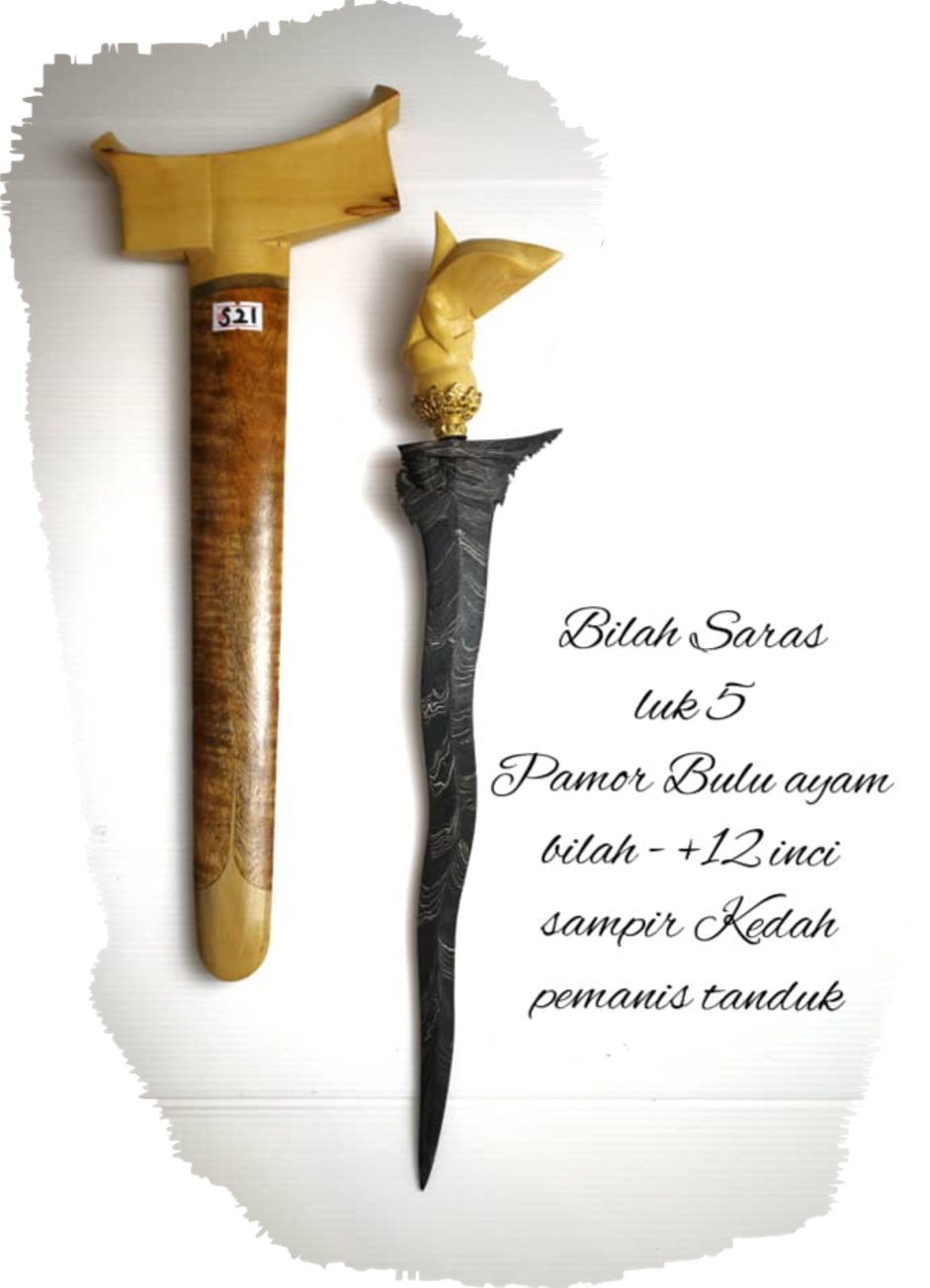
Keris Malela Bilah Saras Luk 5: Seni Budaya Melayu yang Mengagumkan
Oleh Shahabuddin Amerudin Dalam setiap lekukan halus dan pahatan terukir pada sebilah keris, terserlah keindahan warisan agung yang menyatu dengan jati diri bangsa Melayu. Keris Malela Bilah Sara... Read More
How Kuih Jongkong, Bongkok, and Bongkor Became the Pride of Hulu Langat: Uncovering the Origins and Unique Flavors of Traditional Malay Delights
Kuih Jongkong, Bongkok, or Bongkor – three names that are synonymous with the traditional Malay delicacy, known for its unique taste, texture, and aroma. These delectable treats are a favorite a... Read More
The Impact of Time Zone Differences on Sleep Patterns and Human Life: A Case Study of Malaysia
Suggestion for Citation: Amerudin, S. (2023). The Impact of Time Zone Differences on Sleep Patterns and Human Life: A Case Study of Malaysia. [Online] Available at: https://people.utm.my/shahabuddin/?... Read More
Latest Google Site Check Result
Upon conducting a search on the Google website, the results displayed have shown a staggering number of 436,000 results within a lightning-fast time of 0.32 seconds. This is an indication of the vast ... Read More
Peranan Silat dalam Dunia Moden: Warisan Budaya yang Terus Relevan
Oleh Shahabuddin Amerudin Pendahuluan Seni bela diri tradisional Melayu, yang dikenali dengan nama “Silat,” merupakan warisan budaya yang kaya dan berpengaruh di kalangan masyarakat Asia T... Read More
Nurturing the Roots of a Tree
In the midst of the arduous task of tending to the verdant stem and foliage, Let us not disregard the labyrinthine roots that lie in the earth’s ravine. They sustain the mass of the entire arbor... Read More
Akar Pohon
Dalam ketersibukan menjaga teras pohon dan dedaunan Janganlah kau lupa pada akar yang tersembunyi Ia yang menopang seluruh tubuh pohon Tanpa perawatan, ia akan terkubur dalam kelam Siramlah akar denga... Read More
