By Shahabuddin Amerudin
Introduction
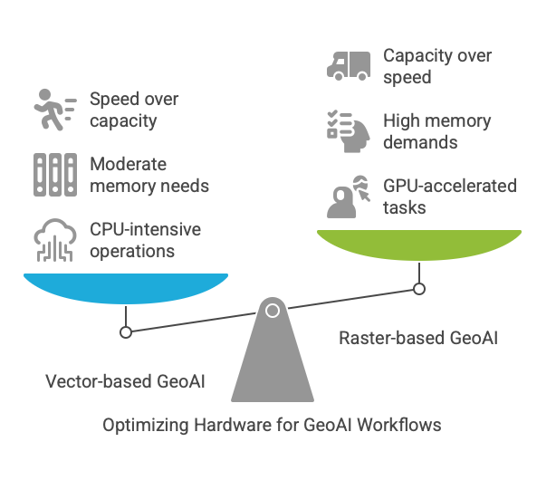
The growing field of Geospatial Artificial Intelligence (GeoAI) represents a fusion of spatial analysis with modern machine learning techniques. However, not all GeoAI work is created equal. While remote sensing applications with massive raster datasets demand extreme hardware configurations, vector-based GeoAI—focusing on points, polylines, and network datasets—creates a distinctly different hardware profile. This article examines the optimal configuration for professionals working primarily with vector geospatial data and provides practical recommendations for making the right investment.
Understanding Vector-Based GeoAI Workflows
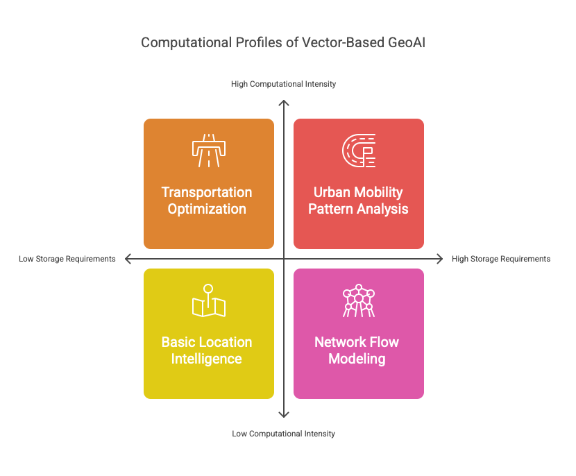
Vector-based GeoAI differs fundamentally from raster-focused applications. Instead of processing satellite imagery or elevation models, these workflows analyze the relationships between discrete spatial features: road networks, points of interest, administrative boundaries, and similar structured data. Common applications include transportation optimization, location intelligence, urban mobility pattern analysis, and network flow modeling.
These applications create a unique computational profile. Vector data typically consumes less storage than raster imagery but demands different processing approaches. Algorithms like shortest path finding, spatial clustering, and network analysis rely heavily on graph theory and computational geometry. Unlike pixel-based operations that process uniform grids, vector analysis often involves complex topological relationships between irregularly distributed features.
The computational implications are significant. Vector processing tends to be more CPU-intensive, with operations that don’t always parallelize as neatly as raster analysis. Memory usage focuses more on data structures like spatial indexes, graph representations, and relational tables rather than large continuous arrays. Storage requirements emphasize random access speed over sheer capacity.
Critical Hardware Components for Vector GeoAI
CPU: The Foundation of Vector Processing
For vector-based GeoAI, the CPU represents the most critical component. Complex spatial operations like network analysis, routing algorithms, and spatial joins place significant demands on processing power. These operations benefit from both multi-threaded performance for parallelizable tasks and strong single-core performance for sequential algorithms.
The 16-core CPU in Apple’s M4 Max chip provides an excellent foundation for vector-based GeoAI work. Its high-performance cores deliver the computational power needed for complex graph algorithms, while providing sufficient parallel processing capability for operations that can be distributed. Transportation network analysis, in particular, benefits from this balance—shortest path algorithms can be compute-intensive, especially when calculating routes across large metropolitan networks with multiple transportation modes and constraints.
Unlike raster processing, where GPU acceleration often provides dramatic speedups, many core vector operations remain primarily CPU-bound. Having robust CPU performance ensures that fundamental spatial analysis operations remain responsive and efficient.
Memory: Balanced Requirements for Vector Data
Memory requirements for vector-based GeoAI occupy a middle ground between typical business applications and data-intensive remote sensing work. While 128GB configurations might be essential for processing multiple satellite images simultaneously, most vector applications can function effectively with more moderate memory pools.
The 64GB unified memory configuration represents an optimal balance for vector-focused workflows. This capacity provides sufficient headroom for complex operations while avoiding unnecessary cost. A metropolitan transportation network with comprehensive attributes might consume 2-5GB of RAM, while routing algorithms could require 10-20GB for complex multi-modal analyses. With 64GB, professionals can maintain multiple network datasets in memory simultaneously, run concurrent analyses, and support in-memory database operations without constant swapping to disk.
For point pattern analysis, a dataset of 10 million POIs with attributes might require 5-10GB, with spatial indexes adding another 2-5GB. Contextual data like demographics or administrative boundaries adds further memory requirements. The 64GB configuration comfortably supports these operations while maintaining system responsiveness for interactive analysis.
GPU: Valuable but Secondary for Vector Work
While the GPU plays a less central role in vector-based GeoAI compared to raster analysis, it still provides meaningful benefits for specific operations. The 40-core GPU in the M4 Max offers performance headroom for visualization of complex networks, acceleration of compatible algorithms, and support for machine learning integration.
For pure vector processing, a less powerful GPU would be sufficient. However, the 40-core configuration provides valuable future-proofing, particularly for professionals who occasionally need to incorporate raster data or train machine learning models. Urban mobility pattern analysis, for example, might utilize machine learning for trajectory clustering and prediction—operations that benefit from GPU acceleration.
The available Mac Studio configuration doesn’t offer a lower GPU core count option with the 16-core CPU, but the 40-core GPU represents a reasonable inclusion rather than an excessive luxury for vector-focused workflows.
Storage: Speed Trumps Capacity
Vector datasets typically occupy significantly less space than their raster counterparts. A comprehensive road network for an entire country might require only a few gigabytes, compared to terabytes for high-resolution satellite imagery of the same area. Consequently, storage capacity becomes less critical than performance for vector-based GeoAI.
The 1TB SSD configuration provides sufficient capacity for most vector-based projects while delivering the high-speed random access essential for database operations. Fast storage ensures responsive performance when querying spatial indexes, retrieving geometries, and writing analysis results. For vector work, the emphasis should be on I/O operations per second rather than raw capacity.
For professionals working exclusively with vector data, external storage solutions can efficiently handle archival needs without requiring expensive internal storage upgrades. The savings from selecting the 1TB configuration instead of larger options can be better allocated to other productivity enhancements.
The Ideal Configuration for Vector-Based GeoAI
Based on this analysis, the Mac Studio configuration with the M4 Max chip (16-core CPU, 40-core GPU), 64GB unified memory, and 1TB SSD storage represents an optimal balance for vector-focused GeoAI work:
- The 16-core CPU provides the processing power needed for complex spatial operations and network analysis algorithms.
- The 64GB memory configuration delivers sufficient capacity for sophisticated vector datasets and analyses without unnecessary cost.
- The 1TB SSD offers adequate storage capacity with the performance characteristics needed for database operations and frequent random access.
- The 40-core GPU, while more than strictly necessary for pure vector work, provides valuable performance headroom for visualization and integrated analytics.
At RM 11,591.50, this configuration delivers excellent value for vector-based GeoAI work. It prioritizes the components most critical for these workflows while avoiding excessive investment in areas that provide diminishing returns for vector processing.
Real-World Applications and Performance
Transportation Network Analysis
Transportation network analysis represents one of the most demanding vector-based GeoAI applications. Modern transportation systems integrate multiple modes (roads, rail, pedestrian paths) with complex attributes (speed limits, congestion patterns, restrictions) into unified networks for analysis.
The Mac Studio with 16-core CPU excels at the graph algorithms underlying transportation analysis. Calculating isochrones (travel time polygons), identifying optimal facility locations, or determining service areas all benefit from the M4 Max’s processing capabilities. The 64GB memory configuration allows researchers to maintain multiple regional networks in memory simultaneously, supporting comparative analysis without constant dataset reloading.
For a medium-sized metropolitan area with detailed road attributes and traffic patterns, analysts can expect to process routing queries in near-real-time, even for complex multi-modal journeys. The storage speed ensures that network attributes and geometries load quickly when needed.
Spatial Point Pattern Analysis
Point pattern analysis examines the distribution of discrete locations—retail stores, disease incidents, crime events—to identify clusters, dispersion patterns, and relationships with environmental factors. These analyses often involve computationally intensive spatial statistics like Ripley’s K-function or Getis-Ord Gi*.
With the 16-core CPU and 64GB memory, analysts can efficiently process point datasets containing millions of features. Nearest neighbor calculations, density estimations, and cluster identification run smoothly even on large datasets. The unified memory architecture of the M4 Max chip provides particular benefits for operations that require frequent data access and transformation.
The spatial databases underpinning these analyses benefit from the fast SSD storage, ensuring responsive performance even when executing complex spatial queries against large point datasets.
Urban Mobility Analytics
Urban mobility analytics examines how people and vehicles move through cities, often utilizing massive GPS trajectory datasets from mobile devices, vehicles, or transportation services. These analyses require processing temporal and spatial dimensions simultaneously to identify patterns, anomalies, and optimization opportunities.
The Mac Studio configuration provides excellent support for mobility analytics. The 64GB memory capacity allows for handling trajectory data for thousands of moving objects across extended time periods. The 16-core CPU efficiently processes spatial-temporal queries and pattern detection algorithms. For machine learning aspects of mobility analysis—predicting traffic conditions or identifying behavioral patterns—the 40-core GPU provides valuable acceleration.
Processing a day’s worth of taxi trajectory data for a major city, including spatial indexing, temporal aggregation, and pattern identification, completes in minutes rather than hours on this hardware configuration.
Cost-Benefit Analysis
The Mac Studio configuration with M4 Max (16-core CPU, 40-core GPU), 64GB memory, and 1TB storage at RM 11,591.50 represents excellent value for vector-focused GeoAI work. Compared to higher-end configurations with 128GB RAM (approximately RM 14,651.50), the savings of around RM 3,060 can be better allocated to:
- Essential peripherals like high-resolution displays that improve workflow efficiency and reduce eye strain during long analysis sessions.
- External storage solutions for data archiving and backup, which provide more cost-effective capacity expansion than internal storage upgrades.
- Professional software licenses for specialized geospatial analysis tools, which often represent significant recurring costs.
- Computing accessories like ergonomic input devices or UPS systems that enhance the overall working environment.
For most vector-based GeoAI applications, the performance difference between 64GB and 128GB memory configurations would be negligible, making the additional investment difficult to justify purely on productivity grounds.
Conclusion: Making the Right Investment
For professionals focusing primarily on vector-based GeoAI—working with points, polylines, and network datasets rather than large raster imagery—the Mac Studio with M4 Max (16-core CPU, 40-core GPU), 64GB memory, and 1TB storage represents the ideal hardware profile.
This configuration aligns computing resources with the actual demands of vector-focused workflows, investing in powerful CPU performance and sufficient memory capacity while avoiding excessive expenditure on components that provide minimal benefits for these specific applications.
When considering the long-term value of this investment, it’s worth remembering that Apple’s hardware typically maintains performance and relevance for 5-7 years. The selected configuration provides sufficient headroom for the evolution of vector-based GeoAI methods and data volumes during this period without paying a premium for capabilities that may never be fully utilized.
For the GeoAI professional focused on network analysis, location intelligence, or mobility patterns, this Mac Studio configuration represents not a compromise but rather a precisely calibrated tool—one that allocates resources exactly where they deliver the greatest benefit for vector-based geospatial work.
