
Category: Knowledge
Sociodemographic Patterns of Convicted Bribe Givers and Solicitors: Unveiling Racial Disparities
Introduction Corruption, a persistent challenge in many societies, corrodes trust in institutions and undermines the rule of law. A deeper understanding of the dynamics behind corruption can provide i... Read More
A Glimpse into the Past: Reviewing the Early Career of Bill Gates and Its Contemporary Relevance
In the early 1970s, a young and driven individual named William H. Gates had his sights set on the rapidly evolving world of computer systems and programming. His resurfaced job application provides a... Read More
Fostering Innovation in Government GIS Applications: A Comprehensive Comparison of Methodologies
By Shahabuddin Amerudin In recent years, the advancement of Geographic Information Systems (GIS) has transformed the way government agencies operate and interact with their constituents. The integrati... Read More
Train PhD Students to Be Thinkers, Not Just Specialists
By Shahabuddin Amerudin Introduction The pursuit of a doctoral degree has long been associated with the idea of becoming an expert in a specific field of study. While specialization is undoubtedly cru... Read More
Harnessing the Power of GIS and Geospatial Data: Architecture, Applications, and Advancements
By Shahabuddin Amerudin In today’s rapidly evolving technological landscape, Geographic Information Systems (GIS) have emerged as indispensable tools that bridge the gap between geography and da... Read More
Mengupas Hubungan Antara Kelas Pendapatan dan Kos Sara Hidup: Cabaran dalam Realiti Sosioekonomi
Pengenalan Kelas pendapatan dan kos sara hidup adalah dua aspek yang tidak dapat dipisahkan dalam landskap ekonomi dan sosial masyarakat. Dalam dunia yang semakin kompleks, perbincangan mengenai bagai... Read More
Navigating Roundabouts in Malaysia
In Malaysia, as in many countries that drive on the left side of the road, the rules for navigating a roundabout are akin to those in similar driving environments. Referring to the diagram above depic... Read More
Chemical Leak Management: Predictive Modelling Techniques using GIS
By Shahabuddin Amerudin Introduction In the intricate landscape of industrial operations, chemical leaks stand as critical challenges that require rapid and precise responses. The fusion of technology... Read More
Chemical Leak at Idemitsu Plant in Pasir Gudang, Johor – Safety Measures and Hazards
By Shahabuddin Amerudin Incident Alert: Chemical Leak at Idemitsu Plant in Pasir Gudang, Johor – Safety Measures and Hazards Introduction A recent chemical leak incident at the Idemitsu (M) Sdn Bhd ... Read More
Choosing Between Web-Based Applications and Native Mobile Apps
By Shahabuddin Amerudin In the dynamic landscape of digital development, the choice between adopting web-based applications and native mobile apps has emerged as a pivotal decision for businesses and ... Read More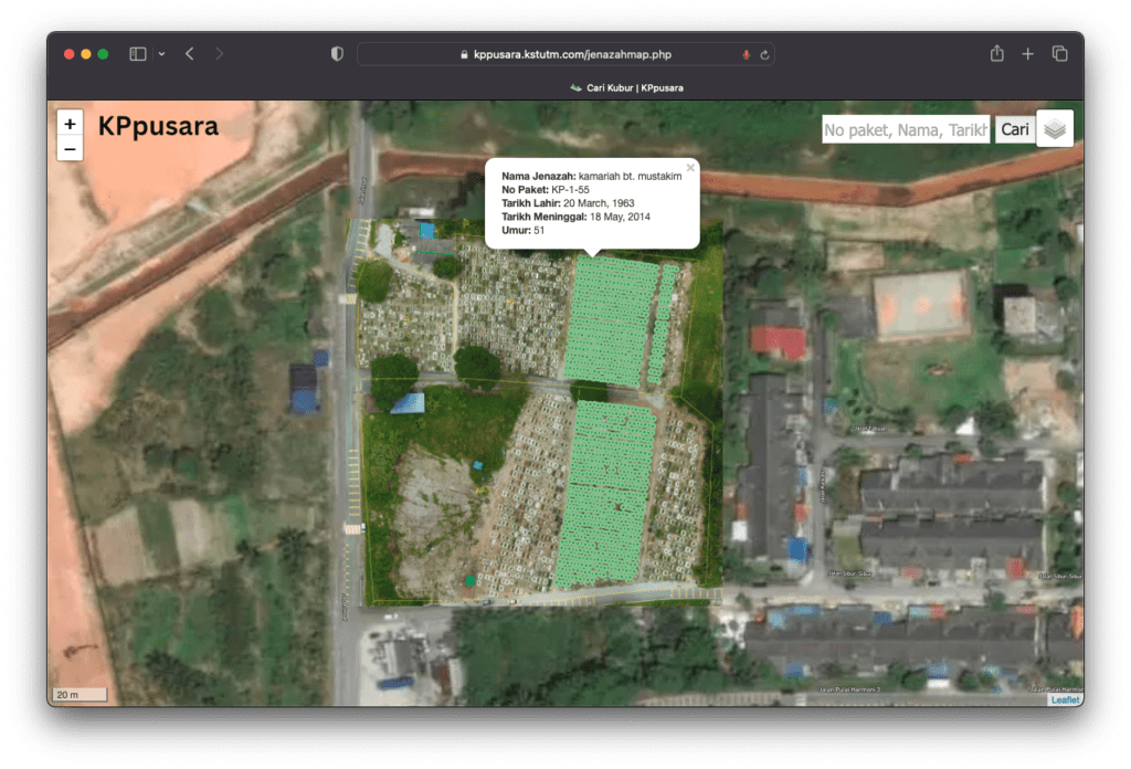
Mengatasi Masalah Pengurusan Tanah Perkuburan melalui Inovasi Teknologi
Oleh Shahabuddin Amerudin Dalam dunia yang semakin berkembang dan penuh dengan kemajuan teknologi, pengurusan tanah perkuburan menghadapi pelbagai cabaran yang semakin rumit. Masyarakat yang berkemban... Read More
Belajar lain kerja pulak lain
Keputusan untuk belajar kursus tertentu di universiti tetapi kemudian bekerja dalam bidang yang tidak berkaitan dan berhutang adalah situasi yang kompleks dan boleh mencetuskan pelbagai isu. Di bawah ... Read More
Unveiling the Power of Geospatial Artificial Intelligence (GeoAI) and its Applications
By Shahabuddin Amerudin Introduction The term Geospatial Artificial Intelligence (GeoAI) lacks a universally agreed-upon definition. Initially, GeoAI referred to the utilisation of machine learning to... Read More
Navigating the Expansive Horizon of Spatial Data Science
By Shahabuddin Amerudin Abstract In recent times, the realm of spatial data science has witnessed an unprecedented surge, propelled by the exponential growth of spatial data and its potential applicat... Read More
The Dynamic Potential of Named Entity Recognition (NER) in Extracting and Analyzing Geospatial Data
By Shahabuddin Amerudin Named Entity Recognition (NER), an integral component of Natural Language Processing (NLP), plays a pivotal role in extracting meaningful information from unstructured text. Th... Read More
Unlocking Textual Insights: The Power and Applications of Named Entity Recognition (NER)
By Shahabuddin Amerudin Named Entity Recognition (NER), often referred to as entity chunking, extraction, or identification, is a vital process in the realm of Natural Language Processing (NLP). It re... Read More
Simplifying Automated Building Footprint Extraction with Deep Learning in GIS
By Shahabuddin Amerudin Abstract This paper delves into the realm of geospatial data processing, highlighting the amalgamation of Python scripting and advanced deep learning techniques for object dete... Read More
Geoscape Greens: A Journey of Innovation and Sustainability – Part 1
By Shahabuddin Amerudin In the vibrant city of Nusantara, nestled between towering skyscrapers and bustling streets, stood the headquarters of GeoSmart Solutions, a leading GIS firm. Among its talente... Read More
