Sinkhole Risk Mapping with GIS and AHP: Kuala Lumpur and Ampang Jaya Case Study

Understanding Sinkhole Susceptibility in Kuala Lumpur and Ampang Jaya: A GIS and AHP-Based Approach

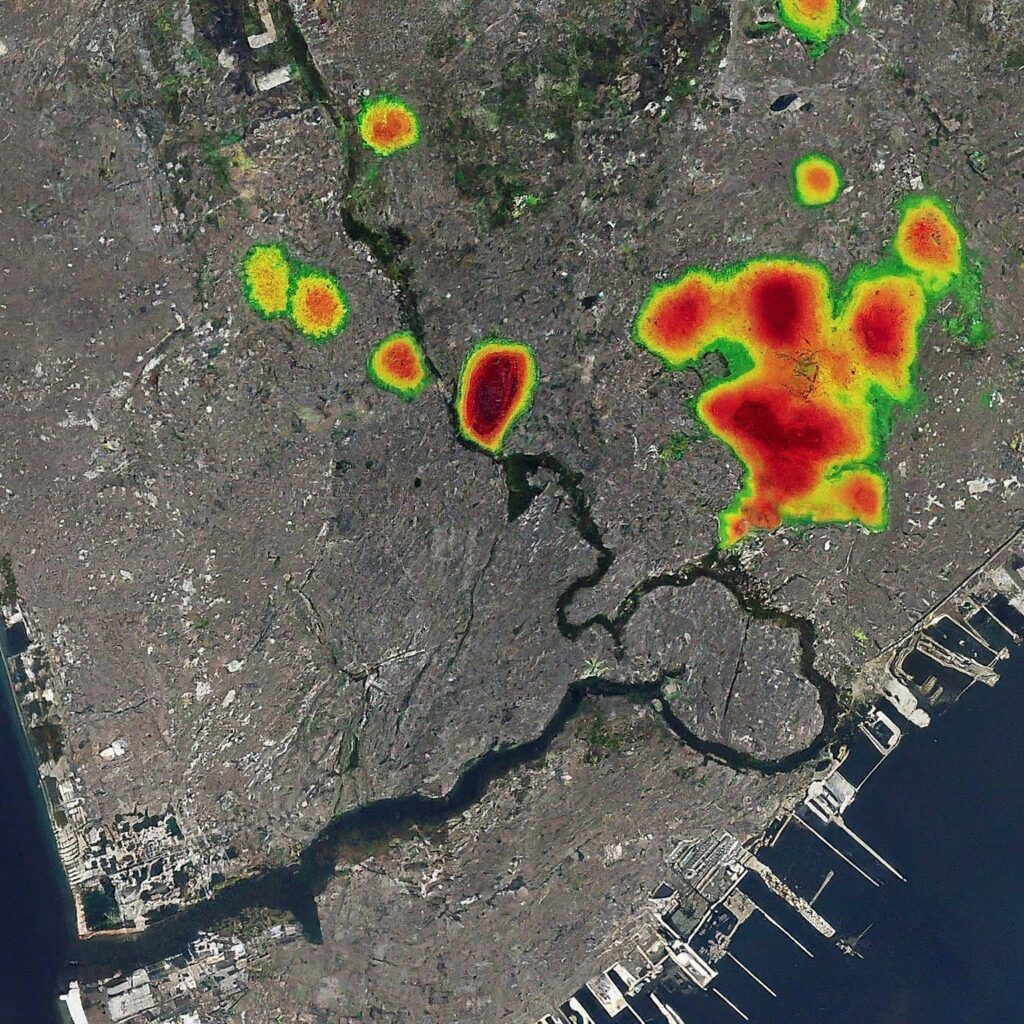
Introduction Sinkholes are a significant geohazard, particularly in urban areas like Kuala Lumpur and Ampang Jaya, where the increasing number of incidents has raised concerns over public safety and urban infrastructure. Since 1968, the Klang Valley region has witnessed a growing frequency of sinkholes, posing serious threats to human lives, assets, and structures, particularly in Malaysia’s bustling capital. To address this issue, Rosdi et al. (2017) conducted a study that employed Geographic Information Systems (GIS) integrated with the Analytical Hierarchical Process (AHP) to develop a Sinkhole Hazard Model (SHM). This article discusses the findings of this study, the methods used, […]

Understanding Sinkhole Susceptibility in Kuala Lumpur and Ampang Jaya: A GIS and AHP-Based Approach Read More »

a retired GIS professional

Penyesalan Terbesar Semasa Bersara

Dalam perbincangan mengenai persaraan, ramai individu cenderung memfokuskan impian mereka untuk bersara awal. Namun, terdapat aspek lain yang sering diabaikan, iaitu penyesalan yang mungkin timbul selepas bersara. Berdasarkan kajian, lima penyesalan utama yang sering dialami oleh pesara adalah seperti berikut: Penyesalan yang paling lazim ialah kegagalan menyimpan dana persaraan yang mencukupi. Ramai pesara berasa mereka sepatutnya memulakan simpanan lebih awal atau bekerja dengan lebih tekun. Mereka juga menyesali pembelian harta atau kenderaan mewah yang tidak diperlukan, menjadi mangsa penipuan kewangan, atau membeli rumah yang melebihi kemampuan. Penyesalan ini mencerminkan kepentingan perancangan kewangan yang teliti sejak usia muda. Sekitar satu perempat

Penyesalan Terbesar Semasa Bersara Read More »

professional GIS

Pendidikan dan Latihan sebagai Keperluan untuk Profesionalisme dalam Bidang GIS

Pindaan Rang Undang-Undang Juruukur Tanah Berlesen (Pindaan) 2024 membawa perubahan besar dalam pendidikan dan latihan dalam bidang Sistem Maklumat Geografi (GIS). Pindaan ini memperkenalkan keperluan piawaian dan pengawalan yang lebih ketat, yang memberi kesan langsung kepada individu dan organisasi yang terlibat dalam kerja-kerja GIS, termasuk mereka yang hanya mengikuti kursus pendek dalam tempoh satu hingga tiga hari, atau beberapa minggu berbanding dengan pendidikan formal yang mengambil masa sehingga empat tahun. Kursus pendek sering digunakan untuk memperkenalkan konsep asas atau kemahiran praktikal dalam GIS kepada profesional yang ingin meningkatkan kemahiran mereka dengan cepat. Namun, dengan adanya pindaan undang-undang ini, timbul keperluan

Pendidikan dan Latihan sebagai Keperluan untuk Profesionalisme dalam Bidang GIS Read More »

GIS man

Pindaan Rang Undang-Undang Juruukur Tanah Berlesen (Pindaan) 2024: Implikasi kepada Industri GIS dan Geospatial

Pindaan Rang Undang-Undang Juruukur Tanah Berlesen (Pindaan) 2024 yang baru sahaja dibentangkan di Parlimen membawa beberapa kesan penting terhadap pelbagai bidang yang melibatkan kerja-kerja geomatik, termasuk Sistem Maklumat Geografi (GIS) dan geospatial. Walaupun pindaan ini secara langsung mensasarkan pengawalan ke atas kerja-kerja ukur tanah yang dilakukan oleh juruukur tanah berlesen, ia turut membawa implikasi penting kepada individu dan organisasi yang terlibat dalam industri GIS dan geospatial. Peningkatan Piawaian dan Pengawalan Salah satu impak utama daripada pindaan ini ialah penguatkuasaan piawaian yang lebih tinggi terhadap data geomatik yang dikendalikan oleh Jabatan Ukur dan Pemetaan Malaysia (JUPEM). Pindaan ini menekankan bahawa hanya

Pindaan Rang Undang-Undang Juruukur Tanah Berlesen (Pindaan) 2024: Implikasi kepada Industri GIS dan Geospatial Read More »

GIS

Kesan Pindaan Rang Undang-Undang Juruukur Tanah Berlesen (Pindaan) 2024 kepada Individu dan Organisasi Berkaitan GIS dan Geospatial

Pindaan Rang Undang-Undang Juruukur Tanah Berlesen (Pindaan) 2024 membawa beberapa perubahan penting yang tidak hanya mempengaruhi juruukur tanah berlesen, tetapi juga memberi kesan signifikan kepada individu dan organisasi yang terlibat dalam kerja-kerja Sistem Maklumat Geografi (GIS) dan geospatial. Artikel ini membincangkan kesan utama pindaan tersebut kepada bidang GIS dan geospatial serta implikasinya terhadap amalan industri. Peningkatan Piawaian Data Geospatial Salah satu kesan utama pindaan ini adalah peningkatan piawaian dalam pengumpulan dan pengurusan data geospatial. Pindaan ini menetapkan syarat yang lebih ketat bagi data geomatik yang disimpan oleh Jabatan Ukur dan Pemetaan Malaysia (JUPEM). Data geospatial yang diperoleh melalui kerja ukur

Kesan Pindaan Rang Undang-Undang Juruukur Tanah Berlesen (Pindaan) 2024 kepada Individu dan Organisasi Berkaitan GIS dan Geospatial Read More »

parlimen

Sesi Perbahasan Rang Undang-Undang Juruukur Tanah Berlesen (Pindaan) 2024

Pengenalan Di parlimen, lima orang pembahas utama dalam perbahasan pindaan Rang Undang-undang Juruukur Tanah Berlesen (Pindaan) 2024 telah membangkitkan isu-isu penting yang berkaitan dengan pindaan tersebut. Yang Berhormat Seputeh bertanya mengenai maksud “survey-accurate techniques” dan mengenai data geomatik yang perlu disimpan oleh JUPEM, serta langkah-langkah pencegahan untuk kesalahan profesional dalam pengukuran. Yang Berhormat Pasir Salak mempersoalkan rasional kenaikan kadar denda dan mencadangkan agar hukuman lebih berat dikenakan terhadap mereka yang melaksanakan kerja ukur tanpa kuasa. Sementara itu, Yang Berhormat Ampang menyoal tentang pendigitalan data geomatik dan perbezaan kadar denda antara juruukur tanah berlesen (JTB) dan individu yang tidak berlesen. Yang

Sesi Perbahasan Rang Undang-Undang Juruukur Tanah Berlesen (Pindaan) 2024 Read More »

surveyor

Rang Undang-Undang Juruukur Tanah Berlesen (Pindaan) 2024: Ringkasan dan Analisis

Ringkasan RUU Juruukur Tanah Berlesen (Pindaan) 2024 Pindaan Akta ini mencerminkan usaha kerajaan untuk memastikan bidang ukur geomatik di Malaysia berkembang selari dengan perubahan teknologi dan meningkatkan tahap profesionalisme dalam kalangan JTB. Analisis RUU Juruukur Tanah Berlesen (Pindaan) 2024 RUU Juruukur Tanah Berlesen (Pindaan) 2024 bertujuan untuk memperbaharui Akta Juruukur Tanah Berlesen 1958 agar selaras dengan perkembangan teknologi dan keperluan semasa dalam bidang geomatik. Perubahan utama dalam pindaan ini termasuk perluasan skop kerja Juruukur Tanah Berlesen (JTB), yang kini dibenarkan untuk melakukan pelbagai jenis pengukuran geomatik dan bukan hanya terhad kepada ukur hak milik tanah. Pengakuan profesionalisme turut dipertingkatkan dengan

Rang Undang-Undang Juruukur Tanah Berlesen (Pindaan) 2024: Ringkasan dan Analisis Read More »

GeoAI and planning

Advancing Urban Planning with GeoAI through Global Street Network Analysis

By Shahabuddin Amerudin Introduction Geographic Artificial Intelligence (GeoAI) integrates Geographic Information Systems (GIS) with artificial intelligence (AI), offering advanced capabilities for urban planning and development. This convergence allows for a more nuanced understanding of spatial dynamics and provides tools to address complex urban challenges. By harnessing GeoAI, urban planners can optimize infrastructure, manage resources more efficiently, and create sustainable urban environments. This article delves into how GeoAI can be applied to enhance city planning by analyzing street network configurations across different global cities. Understanding GeoAI GeoAI represents the intersection of spatial data analysis and AI technologies, including machine learning and

Advancing Urban Planning with GeoAI through Global Street Network Analysis Read More »

network

Leveraging GIS for Enhanced Urban Planning Insights from Global Street Networks

By Shahabuddin Amerudin Introduction Geographic Information Systems (GIS) have become indispensable tools in urban planning, offering the capability to analyze spatial data and derive actionable insights for optimizing city layouts. By examining street network configurations from various global cities, GIS technologies can be leveraged to address urban planning challenges, improve infrastructure, and enhance overall city functionality. This discussion explores how GIS can be applied to different street network patterns, taking into account both historical and contemporary planning strategies. 1. Street Network Analysis and Planning 1.1. Grid vs. Organic Patterns GIS technologies provide robust methods for analyzing the efficiency and effectiveness

Leveraging GIS for Enhanced Urban Planning Insights from Global Street Networks Read More »

Configurations of street networks in densely populated cities

The Influence of Street Network Configurations on Urban Planning and Population Dynamics

By Shahabuddin Amerudin Introduction Urban planning is a multifaceted discipline that orchestrates the development and organization of cities to optimize functionality, sustainability, and livability. A fundamental component of urban planning is the design and configuration of street networks, which serve as the skeletal framework of urban spaces. Street networks not only facilitate transportation and connectivity but also profoundly influence land use patterns, economic activities, social interactions, and environmental outcomes (Hillier & Hanson, 1984; Marshall, 2005). The interplay between street network configurations and city populations is intricate, reflecting historical contexts, geographical constraints, and evolving urban development philosophies. This article delves into

The Influence of Street Network Configurations on Urban Planning and Population Dynamics Read More »

data science and GIS

Integrating GIS with Data Science

Introduction Data science is an interdisciplinary field focused on extracting meaningful insights and knowledge from data using a combination of scientific methods, algorithms, and systems. This field merges principles from statistics, computer science, and domain-specific expertise to analyze and interpret vast and complex datasets. The exponential growth in data availability, along with advances in computational capabilities, has made data science a cornerstone in decision-making processes across various sectors such as business, healthcare, and finance. According to Davenport and Patil (2012), data scientists have been recognized as holding the “Sexiest Job of the 21st Century,” a testament to the growing importance

Integrating GIS with Data Science Read More »

Analyzing the Heatmap of Trent Alexander-Arnold vs. Leeds United Understanding the Heatmap

Analyzing the Heatmap of Trent Alexander-Arnold vs. Leeds United

By Shahabuddin Amerudin The heatmap serves as a visual representation of the areas on the football pitch where Trent Alexander-Arnold was most active during the match against Leeds United. The intensity of the color on the map reflects the frequency of his presence in specific regions, with warmer colors such as red and orange indicating higher levels of activity, and cooler colors like blue and green suggesting lower levels. As expected for a right-back, Alexander-Arnold’s heatmap is predominantly concentrated on the right side of the pitch, revealing his primary role in the defensive third. He also occasionally advances into the

Analyzing the Heatmap of Trent Alexander-Arnold vs. Leeds United Read More »

A Detailed Analysis of the Kra Canal Project

The Kra Canal Project

The proposed Kra Canal project in Southeast Asia, as depicted in the image, is a monumental undertaking that seeks to connect the Andaman Sea to the Gulf of Thailand, thereby creating a shortcut for maritime traffic between Europe and Asia. The intricate design of the canal, characterized by a channel depth of 23 meters, a width of 380 meters, and an embankment slope of 1:2.0, is intended to accommodate large vessels, including those weighing up to 150,000 tons. The project also outlines specific dimensions for various sections of the canal, such as the distance between the dumping area and the embankment. The potential advantages of the Kra Canal project are substantial. By

The Kra Canal Project Read More »

Thailand's Industrial Development Zones: A Potential Game-Changer for Southeast Asia

Thailand’s Industrial Development Zones: A Potential Game-Changer for Southeast Asia

The development of industrial development zones (IDZs) in southern Thailand is poised to have a significant impact on the economic landscape of Southeast Asia, particularly for neighboring countries like Malaysia and Singapore. These zones, which are being established along the Andaman Sea coast, aim to attract foreign investment, create jobs, and stimulate economic growth in the region. The provided image depicts a proposed development plan for the southern region of Thailand, focusing on the creation of industrial development zones along the Andaman Sea coast. The map highlights two primary zones: one near Hat Yai,covering 42,000 acres, and another in the vicinity of Songkhla, spanning 80,000 acres. The plan also outlines a future

Thailand’s Industrial Development Zones: A Potential Game-Changer for Southeast Asia Read More »

The South China Sea: A Maritime Hotspot

The South China Sea: A Maritime Hotspot

The provided image vividly illustrates the complex territorial disputes surrounding the South China Sea. This region, rich in natural resources, has become a focal point of contention among several countries, including China, Taiwan, Vietnam,the Philippines, Malaysia, and Brunei. The overlapping claims, marked by dashed lines on the map, highlight the contentious nature of these territorial disputes. The image also showcases key geographical features, such as the Spratly Islands, Paracel Islands, and Scarborough Shoal,which serve as strategic locations for military and economic activities. These islands and reefs are often at the center of territorial clashes, as countries vie for control over their rich fishing grounds and potential hydrocarbon reserves. The future of the South China Sea remains

The South China Sea: A Maritime Hotspot Read More »

Title: MALAYSIA Subtitle: THE ISLAND WORLD OF THE EASTERN SEAS RACES OF PRIMITIVE CULTURE

Malaysia: The Island World of the Eastern Seas, Races of Primitive Culture

Transcription of the Image Title: MALAYSIA Subtitle: THE ISLAND WORLD OF THE EASTERN SEAS RACES OF PRIMITIVE CULTURE Text: Malaysia is the general designation of a group of islands in the eastern seas, extending out in front of the south-east of Asia, forming the stepping-stone to the mainland of Australia on the one side, and to the “Malanea***” archipelagoes and the island-world in the other. It is invaluable as Indonesia, the Indian Archipelago, and the members of the group include some of the most gigantic islands on the globe, with their magnificent and navigable rivers well known, and their extensive drynesses and

Malaysia: The Island World of the Eastern Seas, Races of Primitive Culture Read More »

The Satellite Image of Medina: A Glimpse into the Heart of Islamic History

The Satellite Image of Medina: A Glimpse into the Heart of Islamic History

By Shahabuddin Amerudin The satellite image provided offers a breathtaking aerial view of Medina, one of the holiest cities in Islam. Located in the Hejaz region of Saudi Arabia, Medina is a city steeped in religious significance and historical importance. At the heart of this image lies Al-Masjid an-Nabawi, the Prophet’s Mosque, which is the focal point of the city both spiritually and geographically. The mosque, easily identifiable by its sprawling courtyards and multiple minarets, is one of the most revered sites in Islam, second only to the Masjid al-Haram in Mecca. Surrounding the mosque, the urban layout of Medina

The Satellite Image of Medina: A Glimpse into the Heart of Islamic History Read More »

Jejak Langkah Sasterawan Negara Usman Awang

Jejak Langkah Sasterawan Negara Usman Awang

Usman Awang, atau nama sebenarnya Wan Osman bin Wan Awang, adalah seorang tokoh sastera yang sangat penting dalam sejarah kesusasteraan Melayu moden. Dilahirkan pada 12 Julai 1929 di Kampung Tanjung Sedili, Kota Tinggi, Johor, beliau terkenal dengan nama pena seperti Tongkat Warrant dan diingati melalui pelbagai puisi serta karya drama yang meninggalkan kesan mendalam terhadap pembacanya. Usman Awang dikenali sebagai seorang penyair yang berjiwa rakyat, dengan karya-karya yang menyentuh isu sosial dan perjuangan kemanusiaan. Perjalanan hidupnya bermula dengan alam persekolahan di Kota Tinggi, Johor pada era kolonial Inggeris. Pada tahun 1937, beliau menyambung persekolahan di Mersing, Johor. Namun, ketika Jepun

Jejak Langkah Sasterawan Negara Usman Awang Read More »

The World's Tallest Buildings in 2024

The World’s Tallest Buildings in 2024

In 2024, the skyline of our cities continues to be dominated by colossal structures, showcasing human ingenuity and architectural brilliance. The world’s tallest buildings are not merely feats of engineering; they are symbols of economic strength, cultural significance, and national pride. The infographic above provides an insightful overview of the tallest buildings globally, reflecting the relentless pursuit of height that defines modern urban development. 1. Burj Khalifa, Dubai (828 meters) Topping the list is the Burj Khalifa in Dubai, standing at an awe-inspiring height of 828 meters. Completed in 2010, this 163-floor skyscraper has become an iconic symbol of Dubai’s

The World’s Tallest Buildings in 2024 Read More »

Mohamed Salah

Mohamed Salah’s Record-Breaking Journey in the Premier League

Mohamed Salah, widely celebrated as the “Egyptian King,” has firmly established himself as one of the most prolific and influential players in Premier League history. His journey from a budding talent to a global football superstar is nothing short of extraordinary. This article delves into Salah’s achievements, examining their significance within the broader context of Premier League history, and comparing them to the feats of other footballing legends. One of Salah’s most remarkable achievements is setting the record for the most goals in a single Premier League season. Before his arrival, the record stood at 31 goals, a mark shared

Mohamed Salah’s Record-Breaking Journey in the Premier League Read More »

Scroll to Top